
The COVID pandemic began to wane as summer approached. Sure, we’d taken pseudo-vacations since its arrival. We went to a couple of lakes and the beach, and experienced an almost normal trip to the South Carolina Lowcountry. Basically we went to places where we could hide for awhile and stay away from other people. So we were itching to get out on the road like we used to do before the world changed.

The Ohio River stretches 981 river miles between Pittsburgh, Pennsylvania and Cairo, Illinois. There it flows into the Mississippi River and continues onward to the Gulf. We followed the water, crossing from one side to the other at many different places. Along the way we covered 625 of those river miles, from Marietta, Ohio (mile 172) to Evansville, Indiana (mile 797). As a result we sampled about two-thirds of its path on this single journey.
An Idea Takes Shape

We didn’t feel comfortable with airlines yet, and I’m not much of a fan of them anyway. Actually, I haven’t taken a flight since February 2020, the longest period of my adult life. Everyone else seemed to be staying close to home, too. We couldn’t find a rental home at a beach or in the mountains, or anywhere tourists might normally go. They were all booked! So we needed to find a counterintuitive place that few others might consider a vacation destination. Somewhere away from the coast. Somewhere within driving distance.
I didn’t particularly care where as long as I could count a few new counties. My wife suggested an area with a lot of blank spaces on my map, centered on Louisville. It seemed to check all of the right boxes. Plus, if I finagled the route properly, I could finally surpass the halfway mark on my county counting obsession. Spoiler alert: my total stood at 50.1% at the end of the trip. Oh, and my older son passed the 1,000 county threshold. That’s not a bad start should he wish to pursue this further for some odd reason.
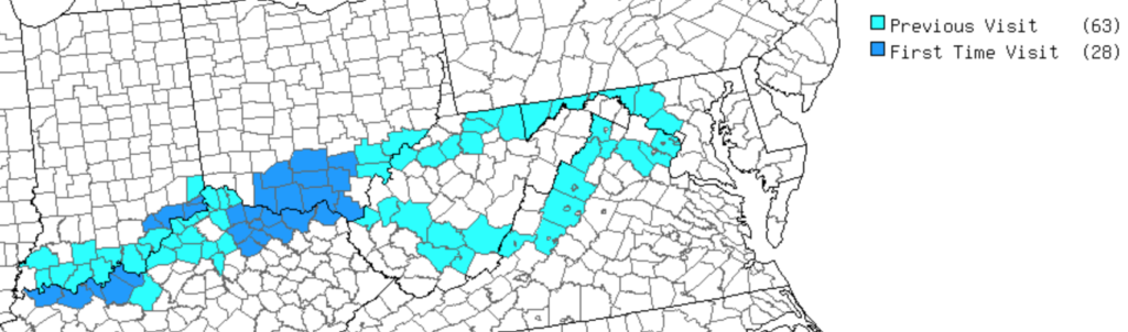
The Route
So Louisville became the focus and we could use that as a home base for single-day excursions. But first we had to get there and then we had to return. Ordinarily I should be able to drive that distance in about 9.5 hours. However, I needed to position ourselves for a much slower route through uncounted counties on both sides of the Ohio River. We couldn’t do it all in one straight shot; we’d need to stay overnight somewhere on the way out and back.
The first and final days, the bookends, involved Interstate driving. I’d already been to all of those counties anyway so they didn’t matter. Those I covered as quickly as possible. Thus it was the second and penultimate days that required careful positioning. I took a southern route on the way out, stopping overnight at Portsmouth, Ohio (map). Then I took a northern route on the way back, stopping overnight in Marietta, Ohio (map). Remember them. I’ll have a lot more to say about them in future articles.
Both towns offered a couple of advantages. I’d never spent the night in either one of them so I could add them to my special “overnight visit” category. Also, each one had a brewpub. That’s all it took. Put a brewpub in your town and I’ll gladly drop some money into the local economy. I’ll purchase a room night in a local hotel, I’ll fill my gas tank, and I’ll buy a couple of meals.
Ruminations

Go ahead and take a look at that map again. Notice those nice, tight clusters of first time visits. I filled a big empty hole too. It took some mighty precise driving to minimize distances if I do say so myself. Also I’ll say that the Louisville area impressed me. It greatly exceeded my expectations, although admittedly I went there without knowing or expecting much. Yes, I’d call this trip one of my more enjoyable and successful journeys I’ve had in awhile.
In addition to counties I added to some of my other obsessive-compulsive “counts”:
- Breweries (11)
- Covered Bridges (2) — and a bunch of interesting non-covered bridges
- Waterfalls (2)
- Caves (2)
- Ferry (1)
- Tiny Church (1)
Unfortunately, every time I fill in a hole I have to travel farther to reach the next set of new counties. I’m not sure where I’ll go next although I currently have my eye on a big open space in eastern North Carolina.
By the way, I visited a ton of places on this trip and this is going to result in lots of articles. So strap yourself in because I’m just getting started.
Articles in the Ohio River Series
- Orientation
- Portsmouth
- Onward Towards Louisville
- Exploring Louisville
- Brewery Cluster
- The Big Four
- Corydon Loop
- Ark Loop
- Evansville Loop
- Heading Back Upstream
- Marietta
See Also: The Complete Photo Album on Flickr
Leave a Reply