
After a warmup loop the day before, we set our sites on something more ambitious. This took us on a course extending northeast of Louisville to the outskirts of Cincinnati. From there we crossed into Indiana and followed the Ohio River.
This combined one very specific destination along with some less structured county counting. I captured no new counties during the Kentucky leg. Later in Indiana I chiseled a slice that covered the counties of Ohio, Switzerland, Jefferson and Scott. The first three counties hugged the banks of the Ohio River.
Ark Encounter
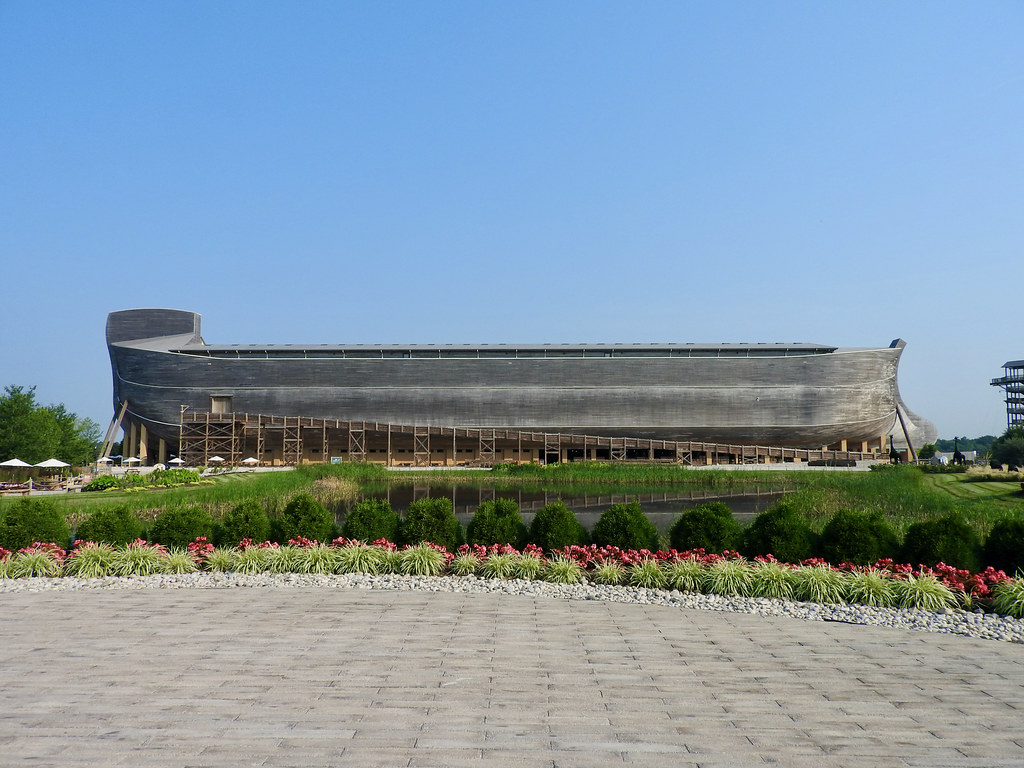
Our intentional destination let us encounter the Ark Encounter. Every good roadside attraction should sit alongside an Interstate highway, and I-75 provided the necessary access here. So we pointed our car towards a spot in the Kentucky countryside about forty miles south of Cincinnati (map).
Young Earth
A Young Earth creationist religious organization opened this representation of Noah’s Ark in 2016. It’s massive. But it’s not really a boat, it’s a building. It wouldn’t float. However, both inside and out it certainly looked like an ark. Or what a strict biblical interpretation of the Genesis flood narrative might consider an ark.
I am not a Young Earth creationist so I more-or-less just appreciated the craftsmanship and presentation. It was top-notch. Plus I figured it’s probably important to expose oneself to differing points of view. My older son went for a specific reason though; he wanted to see the dinosaurs. I probably would have skipped this attraction because of COVID concerns had he not been so insistent.

He knows his dinosaurs and he said these models represented the very latest interpretations. He also said they rivaled or bettered most natural history museums for their current scientific accuracy.
Thus dinosaurs occupied the ark along with every other kind of animal according to this particular point of view. Their theory concluded that dinosaurs survived the flood. Then dinosaurs became extinct in the Middle Ages (e.g., legends of knights fighting “dragons” and such).
Precautions
Yes, you better believe the two of us wore masks. We also got there just as the doors opened for the day and left before it got too crowded. It cost more than $100 for the two of us and even then I didn’t mind a quick exit. And we kept the rest of the family back in Louisville to further minimize potential exposure. In all fairness though, nobody challenged our use of masks or looked at us strangely. People generally tried to maintain a respectful distance throughout the attraction, too.
Aurora

Then we got to the part of the loop that focused on new counties. We drove towards Cincinnati and headed west across the Ohio River, into Indiana. Then we started following the river as it flowed southwesterly. We packed our lunches and now we needed to find somewhere to stop. I figured we’d see a public park in one of the several small towns along our route.
However I didn’t count on being lucky enough to come across Lesko Park in quaint Aurora, Indiana (map). The park occupied an extended stretch of Ohio River waterfront, with easy parking, a bunch of shaded picnic tables, walking paths and a public restroom. What more could we ask for? So we enjoyed our lunch and watched the river.
I liked the flood marker. Apparently the Ohio River floods a lot! I’m not sure what happened in 1963 although the marker noted a “23 Day Flood.” Yikes!
Triple Whipple Bridge
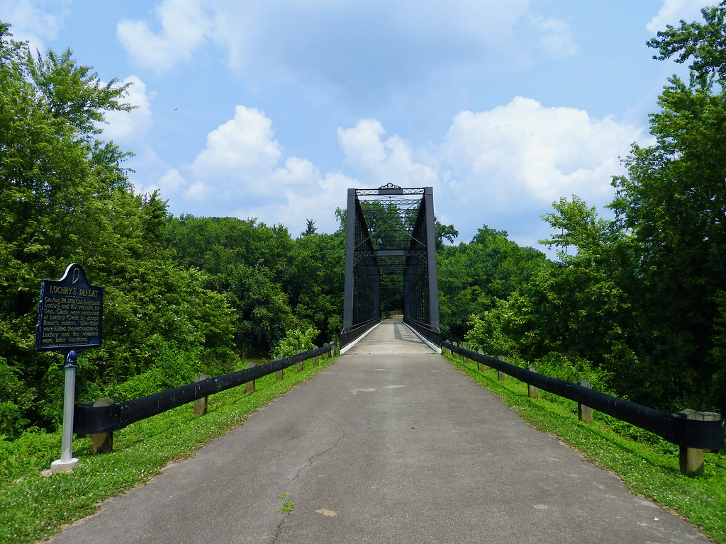
It didn’t take long after that to arrive at the Laughery Creek Bridge, also known as the Triple Whipple Bridge (map). I do enjoy bridges although I may have skipped this one had it not fallen directly along our route. It took like a 30-second detour. Also very little of interest filled this long section of the drive. I was a bit desperate to find something. Anything.
Even so, true bridge aficionados really like this 1878 specimen. It is the sole remaining example of a triple Whipple truss style anywhere. The Historic Bridges website practically drooled over it. They called it “one of the most important historic truss bridges in the country… among the most spectacular and impressive historic bridges standing today.” Your mileage may vary. I called it a nice place to stretch my legs, walk across and take a few photos. Kidding aside, I’m glad someone saved it in 2009 and converted it to pedestrian use.
Something else here impressed me just as much. Laughery Creek marked the border between Dearborn and Ohio Counties. And Ohio County was Indiana’s smallest (87 square miles), least populated (~6,000 people) county. Well, maybe that’s not all that impressive in retrospect. So go there just for the bridge.
Clifty Falls
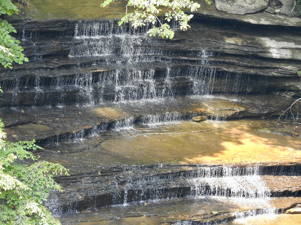
On the other hand, Clifty Falls State Park in Madison, Indiana certainly deserves a longer visit (map). Here, a bluff leads down to the Ohio River valley. The elevation drops about 300 feet over a couple of miles. Clifty Creek empties into the Ohio, carving through the bluff on the way down as it has for millennia. I wouldn’t normally associate steep canyons and waterfalls with Indiana but that’s what happens here (ditto for Illinois a few years ago). So expect four separate waterfalls, great views, lots of hiking trails, and a bunch of amenities. The park even features a lodge although we didn’t stop overnight of course.
Pro Tip: use the northern park entrance. Some of the roads are one-way and this will prevent looping back to see all of the waterfalls.
Leota Covered Bridge

Well, lookie here, another bridge; covered this time. The fine Leota Bridge crossed Coonie Creek near Scottsburg, Indiana (map). Not all covered bridges show an ancient pedigree and this one dated only to 1995. Notice the width of the bridge in the photo. It’s considerably wider than a vintage bridge of this type. Two cars could easily pass through it simultaneously, on pavement. That gave it something of an odd squat appearance, probably because I’ve seen so many others over the years.
I couldn’t find any reason for its existence. Maybe people wanted to attract tourism. Maybe they thought it would be aesthetically pleasing. Wikipedia did mention that two rather old and historic roads met there. So maybe they wanted to recognize that significant spot with something mimicking old and historic. Who knows. We stopped for a moment and then returned to the Interstate to finish our loop back into Louisville.
Articles in the Ohio River Series
- Orientation
- Portsmouth
- Onward Towards Louisville
- Exploring Louisville
- Brewery Cluster
- The Big Four
- Corydon Loop
- Ark Loop
- Evansville Loop
- Heading Back Upstream
- Marietta
See Also: The Complete Photo Album on Flickr
Leave a Reply