
There are 83 Counties in Michigan – “The Wolverine State“
Also be sure to see my United States County Counting Page for the rest of the states.
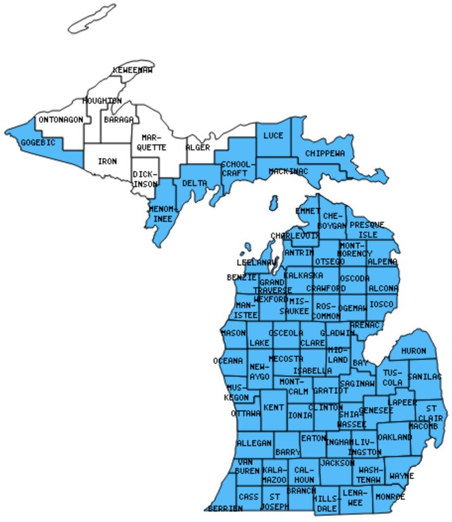
I have visited 75 Counties = 90.4% of Counties in Michigan
Counties visited are colored-in; counties still needing to be visited are blank. Map created using Mob Rule.
Twelve Mile Circle Articles Featuring Places in Michigan
Markers designate the Michigan locations featured in Twelve Mile Circle articles.
Counties in Michigan

Below are the 83 counties in Michigan. Although infrequent, counties sometimes do change so please let me know if any of this information is out of date and I will update it. Those counties that I have visited are highlighted in Red. Readers can also link to any articles manually in this section if the map isn’t working.
- Alcona
- Alger
- Allegan: Saugatuck Dunes
- Alpena: Paul Bunyan of Auto Parts; Giant Eagle Head
- Antrim
- Arenac
- Baraga
- Barry: Barry County Adventure
- Bay
- Benzie: Smallest county in Michigan (321 square miles); Point Betsie Beach; Point Betsie Lighthouse; Welcome to Frankfort
- Berrien
- Branch
- Calhoun: Kellogg’s
- Cass
- Charlevoix: Beaver Island; Beaver Island in the News; Island on an Island; The Pine River
- Cheboygan: Old Mackinac Point Lighthouse; Icebreaker Mackinaw; Wacky Taxidermy
- Chippewa: Longest International Bridges; Lower Tahquamenon (Root Beer) Falls; Museum Ship Valley Camp; Saint Marys River; Soo Locks; Tower of History
- Clare
- Clinton
- Crawford: Tanks and Jet
- Delta: Fayette Historic State Park; Hereford & Hops
- Dickinson: Live Long and Prosper (burp)
- Eaton: I-96/I-69 Concurrency
- Emmet: Fort Michilimackinac; McGulpin Point Lighthouse and Rock; Petoskey Pierhead Light; Petoskey Stones; Roadway Construction; Tunnel of Trees
- Genesee
- Gladwin: Lake Lancer
- Gogebic: Wisconsin to Michigan Bridge; Time Zone Limits
- Grand Traverse: Cherry Capital; North Peak Brewing Company
- Gratiot
- Hillsdale: Do Overs; Howder Street
- Houghton
- Huron: (formerly) Janik’s Orchard
- Ingham: Beaumont Tower; Breslin Center; Deadly Fog; Meridian-Baseline State Park; MSU-Branded McDonald’s; Natural Sciences Building; Not the Usual; Red Cedar River; What’s the Meridian?
- Ionia
- Iosco: Tawas Point Beach; Tawas Point Light Station
- Iron: Michigan Time Zone Anomaly
- Isabella
- Jackson: Centers of Michigan; Meridian-Baseline State Park
- Kalamazoo: Bell’s; Kalamazoo Air Zoo; Named for Schoolcraft
- Kalkaska: National Trout Memorial
- Kent: Founders; Fish Ladder; La Grande Vitesse; 1850 Original City Boundary; Inexplicable Sign; John Howder Marker; Veterans Cemetery; Gerald Ford Museum; John Ball Zoo
- Keweenaw: Smallest county population in Michigan (2,301 people in 2000 Census).
- Lake
- Lapeer: Shortline
- Leelanau: Sleeping Bear Dunes National Lakeshore; Pierce Stocking Scenic Drive; Pierce Stocking Covered Bridge
- Lenawee
- Livingston
- Luce: Two Hearted River; Upper Tahquamenon (Root Beer) Falls
- Mackinac: Arch Rock; British Landing; Castle Rock and Paul Bunyan; Croghan Water; Devil’s Kitchen; Dwightwood Spring; Father Marquette Grave; Fort Holmes; Fort Mackinac; Fort Mackinac Cemetery; Friendship’s Altar; GarLyn Zoo; Gephyrophobia; Grand Hotel; Lime Kiln Ruins; M-185 (Mile 0); Mackinac Bridge; Mackinac Airport; Mackinac Harbor; Mackinac Main Street, Mystery Spot; Northernmost Lake Michigan Marker; Original Butterfly House; Point aux Pins; Robinson’s Folly; Round Island Light; Round Island Passage Light; St. Anthony’s Rock; St. Ignace Coast Guard Station; Skull Cave; Somewhere in Time Gazebo; Somewhere in Time Tree; Sugar Loaf; Wawatam Lighthouse
- Macomb: Cigarette Streets; Comedy Duos; Triple Letter; Centers of Michigan
- Manistee
- Marquette: Largest county in Michigan (1,821 square miles).
- Mason: Lake Michigan Car Ferry
- Mecosta
- Menominee
- Midland: The Tridge
- Missaukee: Wayside Chapel
- Monroe: Custer Monument; Do Overs; Michigan’s Lost Peninsula; Lost Again
- Montcalm
- Montmorency: Elk Capital
- Muskegon: Smith Ryerson Park; USS Silversides; South Breakwater Light
- Newaygo
- Oakland: Detroit Zoo
- Oceana: Rothbury Rest Area 529
- Ogemaw: Highway Brewing
- Ontonagon: Michigan Time Zone Anomaly; Lighthouse Keeper
- Osceola
- Oscoda: Indian Head
- Otsego: 45th Parallel; Alpine Village; Gaylord’s City Elk Park
- Ottawa: New Holland; De Zwaan
- Presque Isle: Presque Isle Lighthouses; 40 Mile Point Lighthouse; Joseph S. Fay Shipwreck; Limestone Quarry
- Roscommon
- Saginaw: Holz Brücke; Bronner’s CHRISTmas Wonderland; Frankenmuth River Place Shops
- Sanilac: Wing Barn
- Schoolcraft: Named for Schoolcraft
- Shiawassee
- St. Clair: Blue Water Bridge; Fort Gratiot Light; Walpole Algonac Ferry
- St. Joseph: Mottville Camelback Bridge
- Tuscola: Mayville Museum
- Van Buren
- Washtenaw
- Wayne: Largest county population in Michigan (2,061,162 people in 2000 Census); Belle Isle Aquarium; Belle Isle Conservatory; Elmwood Cemetery; Gargantuan Garages; Gibraltaresque; Going Postal; Great Lakes Museum; Holy Redeemer; King Boring and the Detroit Gems; King Boring Park; Named for Schoolcraft; Pre-Nazi Swastikas; Simply Boring; The Henry Ford; Wandering through Real Estate
- Wexford
Quick Facts About Michigan
- Location: East North Central United States. See map above.
- Size(1): 56,539 square miles. Michigan is the 22nd largest state. The next larger state is Georgia and the next smaller state is Iowa.
- Population(2): 10,003,000 people. Michigan is the 10th most populous state. The next more populous state is North Carolina and the next less populous state is New Jersey.
- Population Density: 176.9 people per square mile. Michigan is the 18th most densely populated state. The next more densely populated state is Georgia and the next less densely populated state is South Carolina.
- Bordering States: Michigan shares a border with 3 states: Ohio, Indiana and Wisconsin. It also shares a border with Canada and with four of the five Great Lakes; Superior, Michigan, Huron and Erie.
- Admission to the Union: January 26, 1837. Michigan was the 26th state admitted to the Union, after Arkansas and before Tennessee.
- Capital: Lansing.
- Highest Point: 1,971 feet at Mount Arvon. See SummitPost’s Mount Arvon page.
- Lowest Point: 571 feet at Lake Erie in Monroe County.
- Government website: michigan.gov.
- Official Tourism website: Pure Michigan Travel.
- Still not enough? See Wikipedia’s Michigan page.
Sources:
(1) Wikipedia: List of U.S. states and territories by area. Land area only.
(2) Wikipedia: List of states and territories of the United States by population. Estimated population on July 1, 2019.
Leave a Reply