
My older son had to get back to Michigan State University for the start of the new semester and it was my turn to drive. It takes about nine hours to get there under ordinary circumstances so it involves an overnight stay in East Lansing. Then, I figured, I might as well stay a little extra since it was a holiday weekend and I had the time. That way I could snag a few new counties and add them to my county counting list.
But of course, plans change.
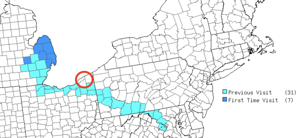
It didn’t start out as the Thumb Drive, or at least not completely. See the little red circle? Right. It’s empty. Originally I planned to visit only the lower section of Michigan’s thumb on this trip. Then I’d take two days driving back home, go a little off-path, and catch those three counties in far northeastern Ohio.
Unfortunately a major snowstorm came through the Mid-Atlantic region, extending into western Pennsylvania and eastern Ohio. We drove up to Michigan in beautiful weather on Saturday. The storm came through on Sunday evening into Monday, dumping a foot of snow on the Pennsylvania Turnpike. So I remained in Michigan an extra day and let the plows clear the highways further east. The Ohio counties will have to wait awhile longer but I did finish Michigan’s thumb. That’s a nice consolation prize.
First Day Loop
The loop on my first full day in Michigan traced the exact path I intended from the start. I stuck to Interstate highways because I figured Michigan weather might be a problem. Ironically, it was practically balmy for the Upper Midwest in January (30° F. / -1.1° C) with bright blue skies. But the path still made sense and I quickly snagged Macomb, St. Clair and Lapeer Counties. Then I filled the Shiawassee County doughnut hole on my map that taunted me for the last two years. Four new counties, easy peasy.
Detroit Zoo

I also had my frequent road trip buddy on this loop, my son. He didn’t have classes on Sunday so he was available and willing. Of course, it helped that I offered the usual bribe: a zoo visit. Well, it turns out that all of my zoo trips with him over the years served a useful purpose. He is currently pursuing a double-major in college, one of which focuses on Zoology.
Oddly, the Detroit Zoo wasn’t actually located in Detroit (map). It’s not even in Wayne County. Rather, the zoo straddles two suburban towns, Royal Oak and Huntington Woods in neighboring Oakland County. It’s close enough for normal purposes I suppose. I’m not even sure why I’m splitting hairs here. I just found the geographic paradox amusing.
Anyway, zoos are nice although they’re not really my thing. I did enjoy walking around a nearly empty zoo on a pleasant winter morning though. The animals were surprisingly active.
Port Huron
Since the weather cooperated so nicely, I decided to slip into Port Huron at the eastern end of the loop. The town sat at the end of Lake Huron where water flowed into the St. Clair River like the overflow drain in a bathtub. Downriver it would reach the next Great Lake in the chain, Lake Erie. It also created a natural border between the United States and Canada.
Blue Water Bridge
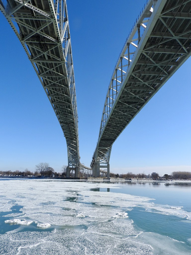
We didn’t cross the Canadian border like we did back in October, but we came within eyesight. The drive itself brought us mighty close to the line and we took the last possible exit without leaving the United States. Otherwise we would have crossed the Blue Water Bridge heading over to Sarnia, Ontario. Instead, we went below the bridge to a waterfront park (map).
Once again I found a situation were I wish I had more time to explore. I’d love to return during the summer too. Nonetheless, we parked there, strolled along the river briefly and took in the sights. We could see Canadians on the other bank doing much the same (photo). I think the most surprising realization was the strong, swift current of the St. Clair River. It pushed powerfully through the slot, as evidenced by the movement of ice in the video I took.
Fort Gratiot Lighthouse
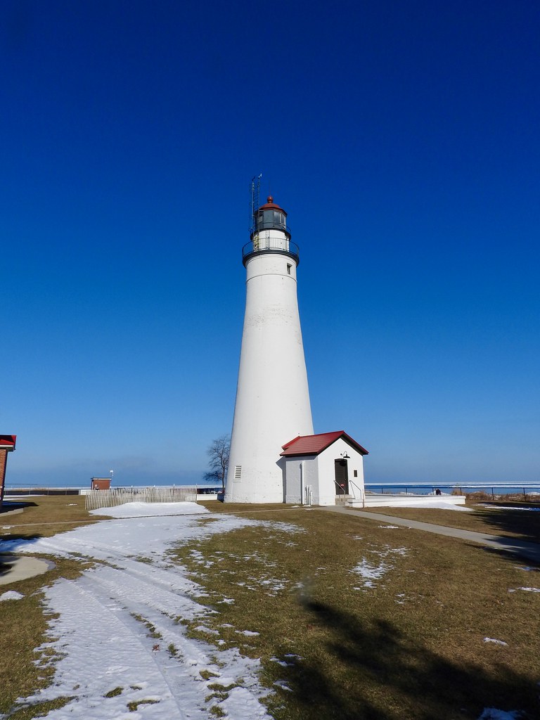
Well of course I was going to get a lighthouse and I found a particularly nice one just up the road from the Blue Water Bridge (map). The U.S. Army built Fort Gratiot in 1814 as a means to protect a strategic point on its frontier, a key juncture on the Great Lakes. This was in the waning days of the War of 1812 so it was vitally important since Canada was enemy territory.
After the war, commerce took off in the Upper Midwest and ships used the Great Lakes to move cargo. However, the spot where Lake Huron spilled into the St. Clair River was particularly treacherous. So the U.S. government decided to build a lighthouse nearby. The initial Fort Gratiot light started lighting the way in 1825 but it fell during a storm. The current incarnation dated to 1829 with additional renovations and height extensions in later decades. Now it stands 82 feet (25 metres) and continues to serve as an active navigational aid.
The tower and museum were closed for the season but we could still walk around the grounds. So we did. Then we returned to the Interstate and continued back towards East Lansing.
See Also: The second day of the adventure on 12MC and the Complete Photo Album on Flickr.
Leave a Reply