
Near Traverse City, Michigan; September 2000
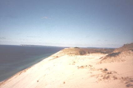
Glaciers scoured the Great Lakes region during the last Ice Age. This mighty forces inundated the countryside, carving out many areas while leaving deposits behind in others. Sleeping Bear Dunes became one of those locations that happened to gain land, and presents rare examples of what are known geologically as “perched” or “cliff-top” dunes.
Vast piles of sand blew across from Wisconsin to the top top of this plateau as glaciers retreated (map). Some of them reach heights of 400 feet or more as they rise steeply along miles of shoreline adjacent to the banks of Lake Michigan. Towering sand dunes are not what one would normally expect more than a thousand miles inland from the ocean and it is an awe-inspiring sight.
The National Park Service created Sleeping Bear Dunes National Lakeshore in 1970. It became one of the newer significant properties in the National Park system. The public certainly benefited from this property coming under protection before it had a chance to be developed extensively like many other places along the Lake Michigan coastline. Dunes, forests, valleys, lakes and shoreline provide abundant natural beauty and a habitat for many of the wild animals that have called this place their home for thousands of years.
Pierce Stocking Scenic Drive
Pierce Stocking Scenic Drive delights many visitors. Pierce Stocking, while having a somewhat unusual name, certainly understood the uniqueness and beauty of the Sleeping Bear Dunes and the local environment.
The Entrepreneur
Pierce Stocking used his skills as a lumberman to forge a road that meandered through the wilderness and up to the top of the dunes. Then in 1967 he opened it to visitors. He owned the drive and operated it as his livelihood until he passed away in 1976. The National Park Service acquired the property the following year and added it to their existing park. They renamed the road in his honor for conceived and building it, the Pierce Stocking Scenic Drive.
The Road
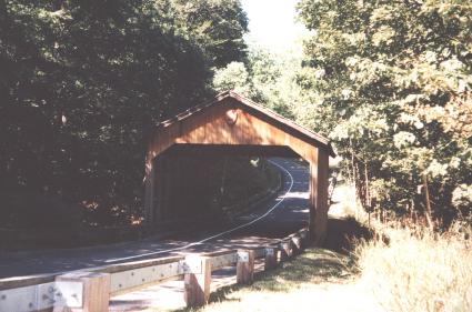
The Scenic Drive forms a 7.5 mile loop with twelve separately numbered stops along the way. It has a 20 mile per hour speed limit along its entire length to protect the many bicyclist, hikers and pedestrians that prefer to see the trail a different way. It also includes a landmark covered bridge (above), picnic areas, scenic overlooks and trailheads.
At one stop an extremely steep path leads down a 450 dune to the shores of Lake Michigan far below. However, the Park Service actively discourages this pathway as it is dangerous and there are other places where visitors can reach the lakeshore easier.
These are the stops that can be explored along the way:
- Covered Bridge
- Glen Lake Overlook & Picnic Mountain
- Picnic Mountain
- Dune Overlook
- Cottonwood Trail
- Dune Ecology
- Leaving the Sand Dunes
- Beech-Maple Forest
- Changes Over Time
- Lake Michigan Overlook
- Sleeping Bear Dune Overlook
- North Bar Lake Overlook
- Pine Plantation
The road closes to all motorized traffic including snowmobiles during winter months. It becomes a quiet, pristine playground for cross-country skiers and snowshoers until the warmth of spring returns.
Inland Lakes
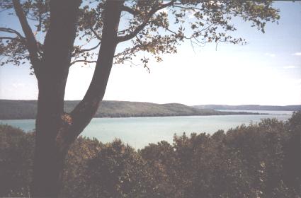
Lakes bracket Sleeping Bear Dunes, with the amazing Lake Michigan shoreline to the west, but also inland lakes carved from the plateau by retreating glaciers on other sides. The largest of these is Glen Lake with more than 6,000 acres of vibrant blue waters of incredible purity. Several small towns dot the shoreline and trails bring hikers around and above it. There are actually two portions of Glen Lake, a smaller western area known as “Little” Glen Lake (shown above) and “Big” Glen Lake to the east.
U.S. Life-Saving Service
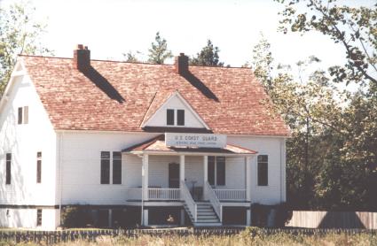
Sleeping Bear Dunes features more than nature. There’s also history. This stretch of coastline fell right along the shipping lanes because of two offshore islands, South and North Manitou, that provided a refuge for ships during stormy weather. Steaming between the shoreline and the islands offered a better option than then open water in the main body of Lake Michigan.
Even so, accidents happened so the U.S. Life-Saving Service operated a station here between 1871 and 1915. This was a government organization staffed with professionals who were trained to row into the roiling surf. They performed dangerous rescues on the high seas when mariners got into trouble.
The Life-Saving Service later joined with the Revenue Cutter Service to form the United States Coast Guard. The structure in the photograph above served as the original base for the Life-Saving Service. However it used to sit in a different spot. Sand dunes started to bury it at its previous location. There are a number of historical exhibits on display at the historic station at any given time. These including numerous artifacts related to life-saving and shipping in the Great Lakes.
Leave a Reply