
I’ll just come out and say it, Mackinac Island is an odd place (map). Lots of people love this scenic spot on Lake Huron for that specific reason, and I admit I enjoyed my brief time there too. But it was disorienting and bewildering to this first time visitor. It felt like a topsy-turvy version of another nearby island, Lake Michigan’s Beaver Island. It’s just a little off-kilter.

Mackinac Island is small; something less than four square miles. Parkland covers most of the island and the overwhelming bulk of visitors stick very close to its only town. Then there are horses. Something like 500+ horses live here, and they do what horses naturally do wherever they wander. I could always tell there were horses around, even with an army of people hired to clean up after them. Horses substitute for automobiles and trucks (which are banned) hauling goods, providing taxi services and claiming the right-of-way through sheer size.
Then mix-in a couple thousand bicycles and many more times pedestrians onto a single Main Street. The population density along here during peak summer months probably rivals some of the more crowded Asian cities. It also mimics a pseudo-Victorian 19th Century vibe in a curated, nostalgic, somewhat artificial theme park kind of way.
Getting There
Most people arrive on Mackinac Island by ferry. Two companies compete for service, Star Line and Shepler’s, and they both operate from two locations, Mackinaw City and St. Ignace. I departed from both ports during my stay specifically so I could add them both to my Ferry Page! Yes, I am compelled by my counting compulsion. Seems normal enough to me.
It’s a short ride, maybe twenty minutes. Most of the day during summer they’re sending ferries from both locations every half-hour, and then shifting to something approximating every fifteen minutes during the peak. So at times there might be as many as sixteen completely packed ferries unloading at Mackinac Island in an hour. That’s a lot of people. No wonder it gets crowded.
Some people arrive by airplane at the island’s general aviation airport. No commercial flights land there but plenty of personal aircraft do, plus a few charters. Nonetheless, I don’t own a plane so I didn’t need to worry about that.
Lighthouses

Two lighthouses sit just outside of Mackinac Island’s harbor. The Round Island Light is the original, and it’s considerably more picturesque than its replacement (map). It went into service in 1895 but fell on hard times after the new one came along mid-century. Restorations continue even today through the efforts of a preservation society.
The newer one, the Round Island Passage Light is essentially an octagonal concrete pole sticking straight out of the water atop a small base. It is completely automated and has never been manned. The light appears in the ferry video I posted above if you simply must see it. It’s functional although not particularly memorable.
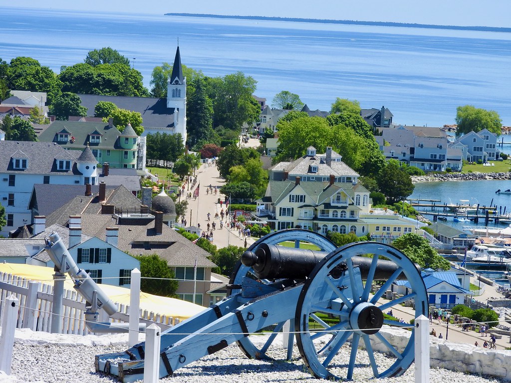
Harbor

The harbor is the first place people see as they arrive by ferry. A lot of the town hugs the harbor so it’s essentially one in the same.
Privately-owned boats fill many of the slips in the protected marina. Our stop coincided with the completion of the Chicago Yacht Club Race to Mackinac, a 113 year tradition as of 2022. Many of the yachts appear in the photo. They’ve just completed a race of more than three hundred miles.
Downtown
The real action for non-yachting tourists happens along Main Street (map). This is where the horses, bicycle and pedestrians all clump together. So anyone needing food, drink, lodging, bike rentals, clothing, souvenirs, ice cream, snacks, or whatever just found the prefect spot. Prices are pretty outrageous but shopkeepers have to make a year’s worth of money during the summer. Plus everything has to be delivered from the mainland by ferry and then reloaded by hand onto drays.
Most of those businesses cluster in about four blocks. Cars in the street aren’t a problem here, but watch out for bicycles and horses!
Oh Fudge!
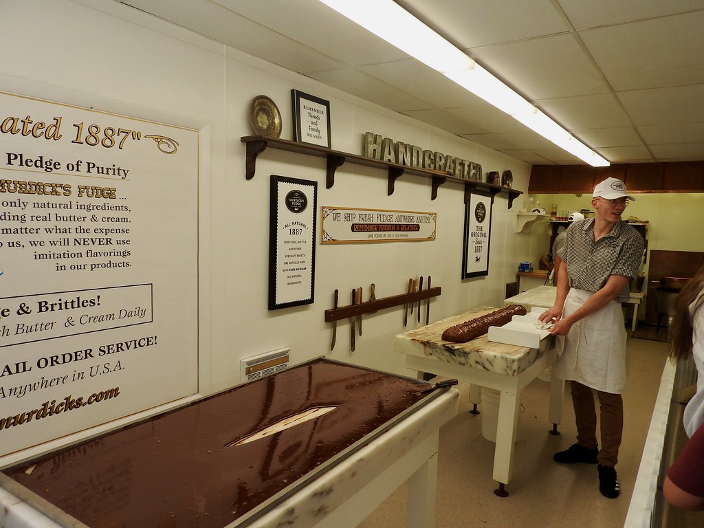
However, one commodity on Mackinac Island completely eclipses all the others: fudge. They’ve been famous for it for well more than a century too.
There’s like a dozen different places making fudge just along Main Street. And some of the companies have separate shops on both sides of the street or down by the ferry docks, so patrons don’t even have to face the inconvenience of a few extra steps. We wouldn’t want anyone burning-off those fudge calories.
It all rather theatrical, the way they spread hot fudge onto large marble slabs and mold it into shape. Of course, that’s part of the appeal. Visitors love to watch the show and then they love to buy more.
Grand Hotel

The one-percenters tend to lodge at the historic Grand Hotel unlike those of us who stayed in St. Ignace and rode the ferry. It really is genuinely “grand” and world famous and an iconic symbol of Mackinac Island and every other superlative, and it has been since 1887. The whole horse-and-buggy thing seems to exist solely to keep the rest of the island frozen in time within the same bygone moment as this single, spectacular hotel. And it simply dominates the visual landscape (map).
Basic rooms run several hundred dollars a night and prices escalate quickly from there. Allegedly the hotel also has the world’s longest porch. I wouldn’t know because they charge admission to see it unless you’re a guest, and I’m cheap. That’s to keep the commoners from gawking, I suppose.
Fort Mackinac
Recently I mentioned that the British abandoned Fort Michilimackinac on the mainland during the American Revolution for a more defensible position. So this was the new spot, right here, high upon a bluff overlooking the harbor (map). They weren’t entirely creative with the name, so they called it Fort Mackinac. It became an American possession after the Revolution although British troops took their sweet time moving out.
Nonetheless, Americans occupied Fort Mackinac before the War of 1812 began. While the fort protected the harbor just fine, the British understood a vulnerability based upon their previous occupation. They simply landed on the other side of the island and marched up behind the fort with a couple of cannons. The Americans, who didn’t even know about the war, surrendered without firing a single shot.
American forces attempted to retake the fort in 1814 but failed. Nonetheless, the United States ultimately won the war and Fort Mackinac returned to American hands, where it remained until its decommissioning in 1895. Now it’s a tourist attraction. People can tour it and watch the cannons fire and stuff.
Original Butterfly House

After all that, we needed a tranquil spot away from the crushing crowds for awhile. Fortunately we ventured a little further along the waterfront and followed signs to the Original Mackinac Island Butterfly House. The main attraction is a greenhouse room where guests can wander freely among hundreds of butterflies (map). They would land on us if we stood still enough. What a relaxing way to end the day.
Articles in the Mackinac’s Orbit Series
- Up North
- Counting Fingers
- Sault Ste. Marie
- Petoskey
- Eastern U.P.
- Mackinaw City
- St. Ignace
- Town of Mackinac Island
- Lake Shore Road
- Into the Highlands
- What’s Brewing?
See Also: The Complete Photo Album on Flickr.
Leave a Reply