
The purpose of the trip wasn’t county counting, it was visiting our older kid who worked on Mackinac Island for the summer. Even so, I still had a bunch of uncounted counties in that area so I planned to use that convenient occurrence to my advantage. That’s how a day that normally should involve a single hour of driving consumed more than four.
What’s the most direct route between Gaylord and St. Ignace, Michigan? Well, this certainly isn’t it:
It combined multiple layers of inefficiency. Not only was it indirect on its surface, it also featured a notch extending even further southward. I actually had to give up hard-earned latitude along the way. However this resolved a two-county doughnut hole and that was the only way. I wasn’t about to leave a blank spot behind and then have to stare at it on my map for who-knows-how-long.
This made my tally on the Lower Peninsula grow by six new counties. I already talked about locations found in two of the six in the previous article; Gaylord (in Otsego) and Atlanta (in Montmorency). So this one will venture into Oscoda, Alcona, Alpena, and Presque Isle. I finished the remaining fingers in Michigan’s geographical “mitten” by the end of the day.
Big Things
One can’t be particularly choosy when meandering through obscure corners of the rural world. Any interesting feature or roadside attraction will do in those cases. And few things define Americana more than giant-sized representations of familiar objects. Naturally RoadsideAmerica and Atlas Obscura were particularly helpful here.
Big Stone Head
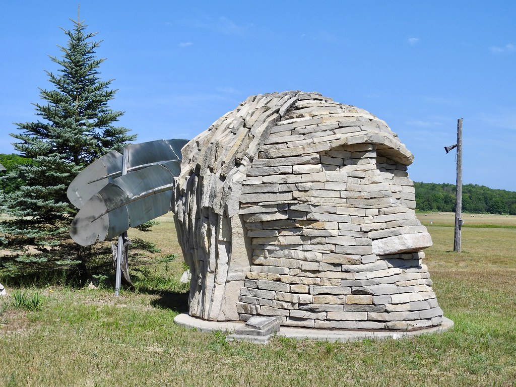
For instance, there wasn’t much to examine as we drove down a backcountry highway into Fairview, Michigan. Suddenly the head of a Native American composed of stone appeared at the bottom of a hill (map). So we stopped. I probably wouldn’t recommend going out of the way for this one but it might be worth a minute or two when driving directly past it.
Big Paul Bunyan

Giant replicas of folklore’s Paul Bunyan exist ubiquitously throughout the upper Midwest, either with or without his blue ox, Babe. I’ve encountered plenty of them before, including another one later in this same trip. However this one was made of sheet metal and other discarded parts from junked automobiles. So I guess that made it slightly more interesting, or maybe even unique?
He stood at the Alpena Community College parking lot next to a large pile of logs (map).
Big Eagle Head
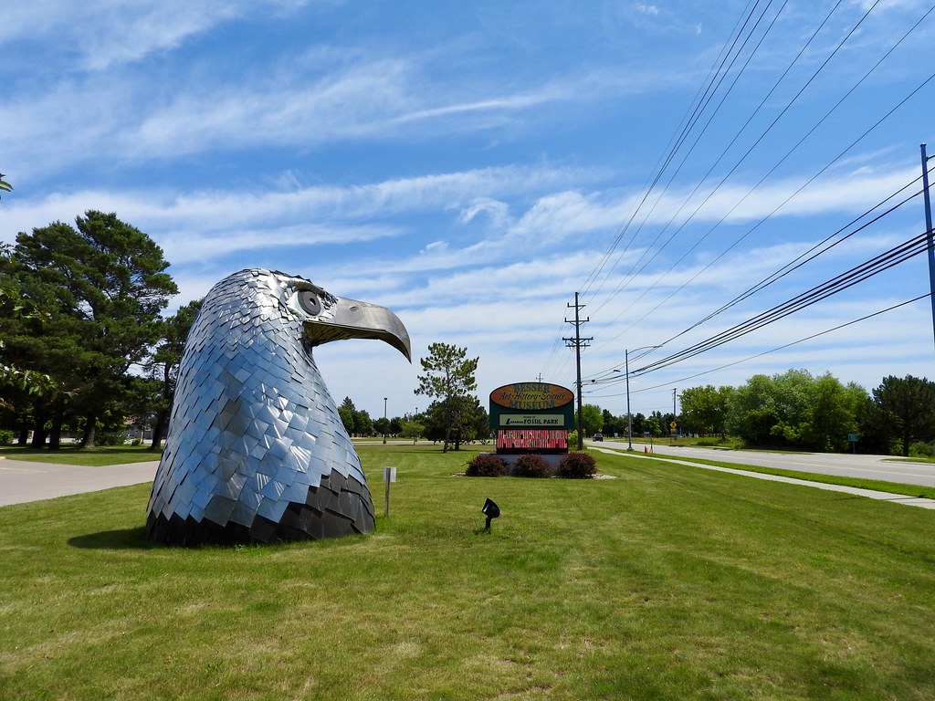
I didn’t expect this one. I always plan my drives in excruciating detail and I totally stumbled on this ginormous eagle head. It sat outside of the Besser Museum for Northeast Michigan, just a stone’s throw from Paul Bunyan (map).
How could I not stop for a moment with it being so tantalizingly close to Paul? Nothing says ‘Murica like a decapitated stainless steel eagle! And I mean that in the best possible way as an aficionado of such displays.
Lighthouses
Then we began the lighthouse phase of the drive, hugging the shoreline of Lake Huron for the next hundred miles. If there are ships and shores then there’s bound to be lighthouses.
Of course I couldn’t contain my glee because I count those things too. What is wrong with me with all this counting? I counted plenty of other things on this trip too and I plan to feature them in future articles, so be warned.
Presque Isle
We pressed along the edge of Lake Huron north of Alpena until we reached a series of interrelated lighthouses less than two miles apart on the Presque Isle peninsula. The grouping sat a few miles southeast of Rogers City. (map).
Front Range Light
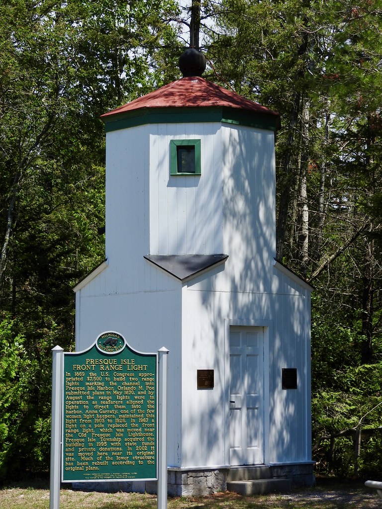
First up came the most ordinary of the trio, the Presque Isle Front Range Light. Think of it as an appetizer for more impressive things to come. This was one of two nearby range lights build circa 1870 that aligned in sequence to direct ships into harbor. This logical solution operated successfully for decades. However a simple light on a pole replaced it in the 1960’s.
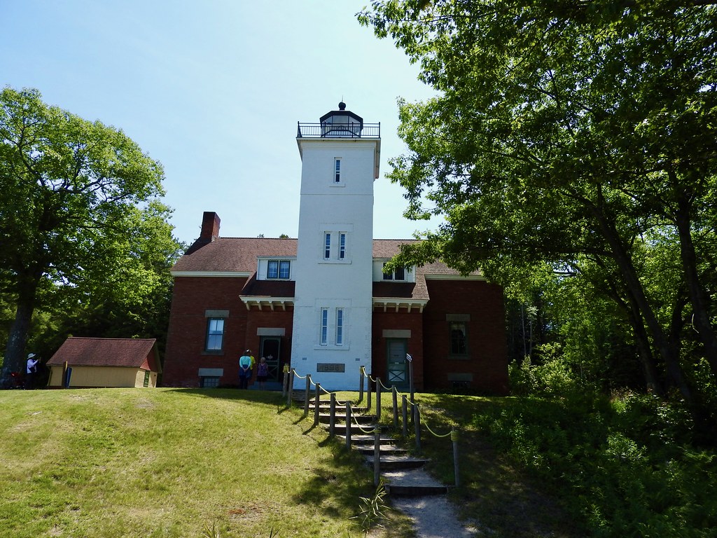
Old Presque Isle Light
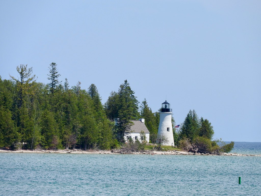
Nearby sat the Old Presque Isle Light. I took this shot from the beach at the Front Range Light and it shows their physical proximity. They are quite close. This light was a bit older — as the name implied — constructed back in the 1840’s.
However, harsh wintertime weather quickly took its toll on the structure. The light hasn’t served as an active navigational aid for ages although it survives as an historical landmark and museum. Visitors can tour both the cottage and the tower.
New Presque Isle Light
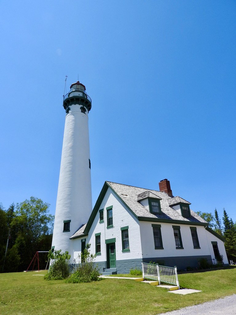
Then we moved onto the final structure of the triad. This is the new Presque Isle light that replaced the old one in 1870. So it’s not all that “new” although certainly newer than the previous one. The tower reaches about 120 feet and visitors can climb to the top for expansive views along the peninsula and out onto the lake. A single admission provides access to the old and the new lighthouses and their respective museums so that was a bonus.
40 Mile Point
But we weren’t done with lighthouses even though you may be tired of reading about them. Further up the coast another half an hour or so sat yet another lighthouse at 40 Mile Point (map). This one seemed more accessible and it attracted considerably larger crowds. The lighthouse park contained not only the quarters and the tower but several other exhibits, plus direct access to a beach.
And More
All those sites seemed like they should have filled an entire day, and yet we pressed on. We still had some distance to cover before we arrived at our home for the week in St. Ignace.
Shipwreck
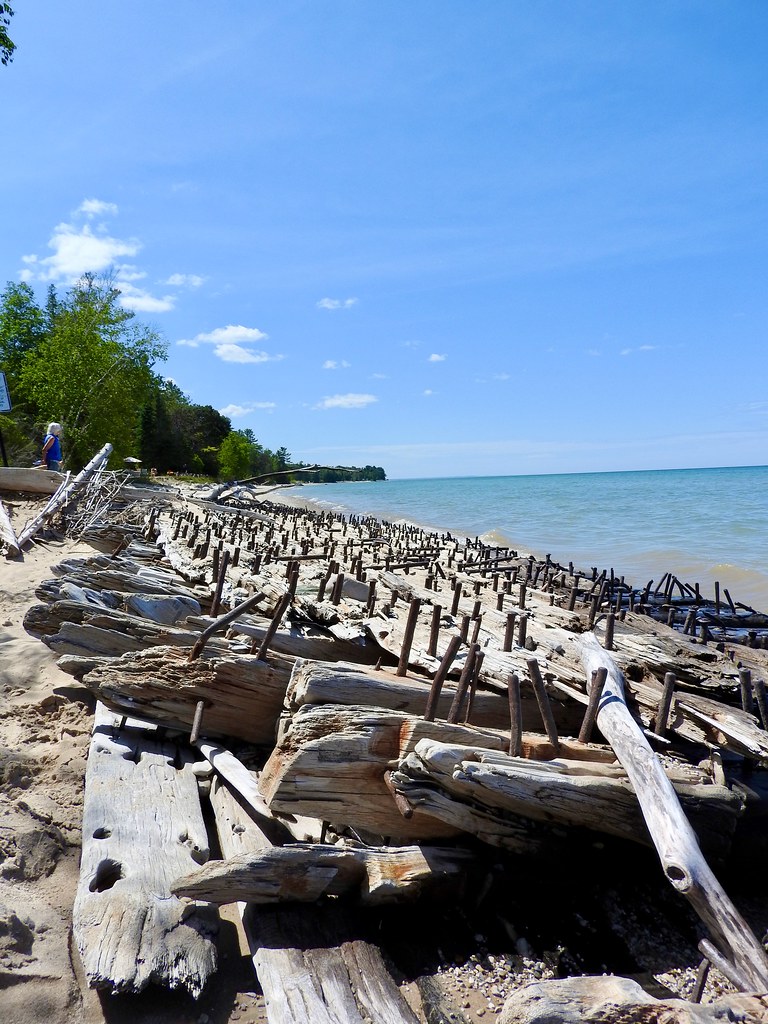
Before we left the 40 Mile Point Lighthouse we wandered down the beach and followed signs to an old shipwreck. This was all that remained of the Joseph S. Fay, a wooden steamer loaded with iron ore that sank in heavy seas in 1905. I’m amazed that even this much remained after more than a century exposed to the elements.
Quarry View

The last landmark on the drive differed considerably from any of the proceeding themes. On the outskirts of Rogers City sat an odd landscape. It was a huge limestone quarry , actually the world’s largest (map). Miners first started digging on this spot more than a century ago and efforts continue today with the current owners, Michigan Limestone and Chemical Company.
I didn’t know whether to be impressed or horrified. But either way it contrasted starkly with the rest of the Lake Huron shoreline. It was certainly easy to spot, too. The company even provided a pull-off with a scenic overlook complete with a viewing platform. They seemed pleased to show the results of their excavation.
Articles in the Mackinac’s Orbit Series
- Up North
- Counting Fingers
- Sault Ste. Marie
- Petoskey
- Eastern U.P.
- Mackinaw City
- St. Ignace
- Town of Mackinac Island
- Lake Shore Road
- Into the Highlands
- What’s Brewing?
See Also: The Complete Photo Album on Flickr.
Leave a Reply