
We drew ever closer to our ultimate target. Only a fifteen minute ferry ride separated us from Mackinac Island today, a place we could see quite clearly from the mainland shore. However, we focused on Mackinaw City and its immediate surroundings so the island had to wait.
Mackinaw City is nothing like Mackinac Island despite their nearly identical names. Think of it as the island’s cheaper, middle-class cousin. Really, who can afford a hotel on Mackinac Island? Those who aren’t hedge fund managers or crypto millionaires stay in Mackinaw City, with its budget hotels and burger joints and take day-trips to the island instead.
Also it genuinely interested me from a geographic perspective, beyond the usual tourist attractions. A boundary line split the town, with separate sections falling into Emmet and Cheboygan Counties. Emmet sat to the west and Cheboygan to the east, with a border generally following Nicolet Street (map).
Central Avenue
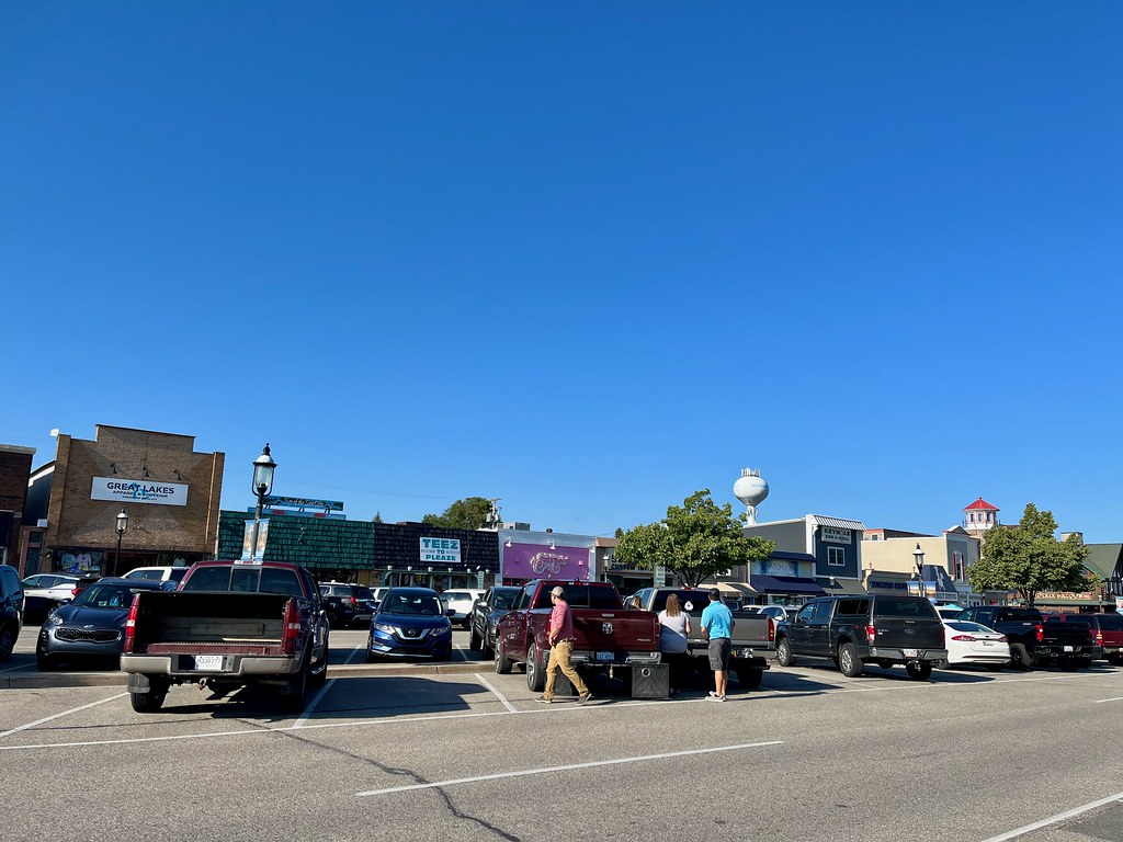
Even so, the real action happened along Central Avenue, an east-west street, once it crossed into to the Cheboygan side of the line (map). Storefronts straddled both sides of Central Avenue with a parking strip occupying a wide median down the middle.
It felt very familiar, almost like an east coast beach town, maybe something out of New Jersey or Delaware. Typical “beach” shopping lined the streets. You know, T-shirt stands, sandwich shops, fried food, homemade fudge, escape rooms, miniature golf, souvenirs, gifts and knickknacks. All the beachfront regulars. Then it dawned on me; it’s doppelgänger was Rehoboth Avenue in Rehoboth Beach, Delaware with the same road/parking layout, interchangeable vibe, and similar orientation perpendicular to the water.
Wacky Taxidermy

But the absolute top attraction in downtown Mackinaw City was the Wacky Taxidermy & Miniatures Museum (map). Hands down, if I could choose only a single stop in town, this would be the place. I bestow a coveted Twelve Mile Circle seal of approval.
Just look at the incredible detail of the school diorama I posted above. There were dozens of different scenes throughout the museum just as amazing. What could be more entertaining than staged anthropomorphic rodents and other permanently preserved critters? Oh how I love these offbeat passion-projects, as loyal readers know.
I had the hardest time matching my touring schedule with their open hours for the longest time. Finally I hit a window just as they opened one day and I got to tour the place before any other visitors arrived. It’s only two rooms but it’s absolutely stuffed (pun intended?) with exhibits. I also got to chat with the owners before I left, a nice artistic couple incredibly devoted to their project.
So stop by if you’re ever in Mackinaw City! It’s very reasonably priced and you won’t be disappointed.
Fort Michilimackinac
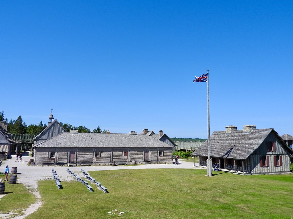
Just try to pronounce Michilimackinac. I can’t. Regardless of how it’s said, it’s the site of an early European fortification now reconstructed as the centerpiece of Colonial Michilimackinac (map). French voyageurs established a permanent post here in 1715 and traded with the local Native population; mainly furs but other commodities too.
It switched allegiances in 1761 after the British victory in the French and Indian War. But the British abandoned the fort during the American Revolution a couple of decades later. They moved across the Straits of Mackinac to a more secure location on Mackinac Island. I’d explore that fort too, later in the trip.
Michilimackinac once appeared as a comment on an old Twelve Mile Circle called Union Jack Over the USA. Sure enough, I can confirm that a variant of the Union Jack flew over Fort Michilimackinac. That’s because it’s a living history museum set during the British era of occupation.
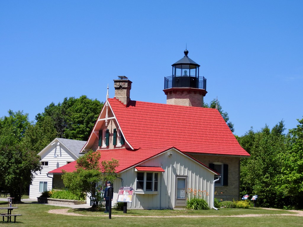
Old Mackinac Point Lighthouse
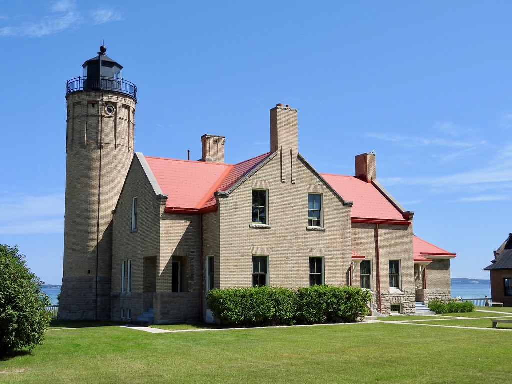
The Old Mackinac Point Lighthouse sits practically next to Fort Michilimackinac. In fact they use the same parking lot. It has wonderfully clear views all the way across the Straits (map). Obviously that makes sense, because mariners needed a lighthouse to guide them at a vital point to turn along a difficult passage.
This lighthouse began operated as an active navigational in 1890. However it closed in 1957 with the completion of the Mackinac Bridge because the bridge had plenty of lights from one end to the other. Nobody needed a lighthouse anymore.
Icebreaker Mackinaw Maritime Museum
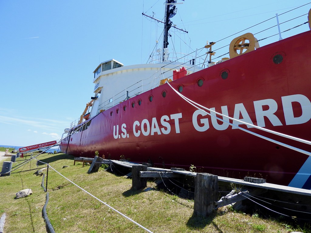
Then we moved a few blocks away along the shoreline to the Icebreaker Mackinaw Maritime Museum. I explained the difference between Mackinac and Mackinaw in an earlier article so I won’t rehash that story. Just note that the ship ends with “w” so that means it’s named specifically for the town (map).
This Coast Guard icebreaker served longer than I imagined — decommissioned only in 2006 — so she served for more than sixty years. She spent her entire service history working out of nearby Cheboygan, keeping Great Lakes shipping lanes navigable during long, cold winters.
McGulpin Point Lighthouse
Not quite in the heart of Mackinaw City, but just a couple miles west, stands the McGulpin Point Lighthouse (map). This one was a bit older, activated in 1869. However, it didn’t last very long even though it’s such a lovely building, barely making it into the 20th Century. That’s because the previously-mentioned Old Mackinac Point lighthouse replaced it.
McGulpin Rock
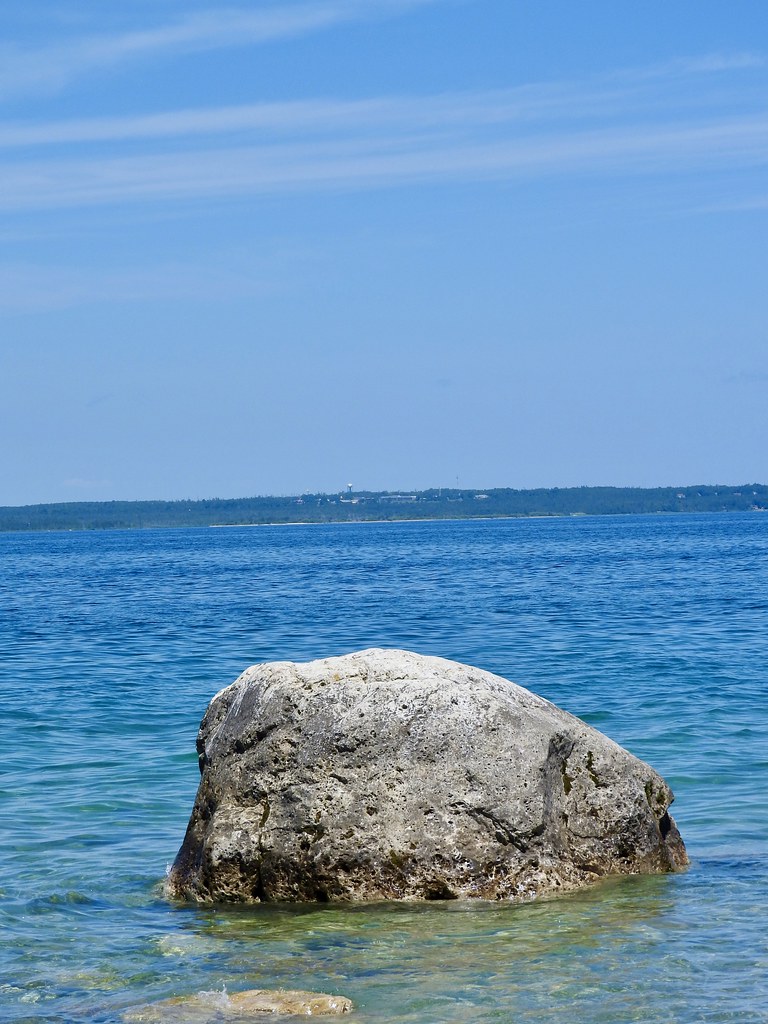
Then we noticed a reference to McGulpin Rock on a sign near the lighthouse (map). It pointed down a shaded path through the woods in the general direction of the lake. So we took a short walk to see the rock because it seemed like the thing to do and we were practically there anyway. I can happily report that, indeed, it was a rock.
However, this isn’t just any ordinary rock it’s a special rock. It’s long been a landmark, first observed by Native inhabitants way before Europeans dreamed of heading inland. But the rock was important to the Europeans too, once they arrived and noticed it. The French first mentioned it in 1615, referencing its fortunate placement as a navigational aid. So that’s the significance, and that’s why a lighthouse stands on the same basic spot, hundreds of years later.
The water level of the Great Lakes fluctuates from year-to-year. It was higher than average during our visit so the rock was less visible than usual. I’m sure it’s much more impressive a lot of the time. Maybe it stands out more for navigators on passing ships but it looked like just another rock to me. Nonetheless, it’s infinitely more impressive than Plymouth Rock.
Articles in the Mackinac’s Orbit Series
- Up North
- Counting Fingers
- Sault Ste. Marie
- Petoskey
- Eastern U.P.
- Mackinaw City
- St. Ignace
- Town of Mackinac Island
- Lake Shore Road
- Into the Highlands
- What’s Brewing?
See Also: The Complete Photo Album on Flickr.
Leave a Reply