
Staying in St. Ignace for a week was a whole lot cheaper than staying on Mackinac Island. It was also a lot easier to use as a base for exploring the eastern end of Michigan’s Upper Peninsula. Once, many years ago, I drove along the southern edge of the U.P. and stayed overnight. Other than that, I’d never spent much time in this area so I was eager to search.
So I took care of that during the week by poking around various corners. Someone could hit a bunch of places using a rather straightforward loop per the map above although we did it as a couple of out-and-backs.
Tahquamenon Falls
I posted an article way back in 2014 called Beery Places. In it I referenced “Root Beer Falls,” an informal designation for a set of falls more properly called Tahquamenon. Consulting the Twelve Mile Circle Complete Index — as I always do before every excursion — I noticed that earlier mention. It seemed like something I should add to the itinerary, so I did. I love having my own personalized adventure generator.
Tahquamenon is the largest set of falls in Michigan, descending along a river of the same name just a few miles before it drains into Lake Superior. The “Root Beer” nickname came from its unusual color. Naturally occurring tannins leach from native flora such as cedar, hemlock and spruce.
That concoction draines into the river as it has done for millennia and tinges it brown. Come to think of it, the process more closely resembles the recipe for ice tea than root beer, but you get the point. The river isn’t “dirty” although it exhibits a color one normally doesn’t expect either.
Upper Falls
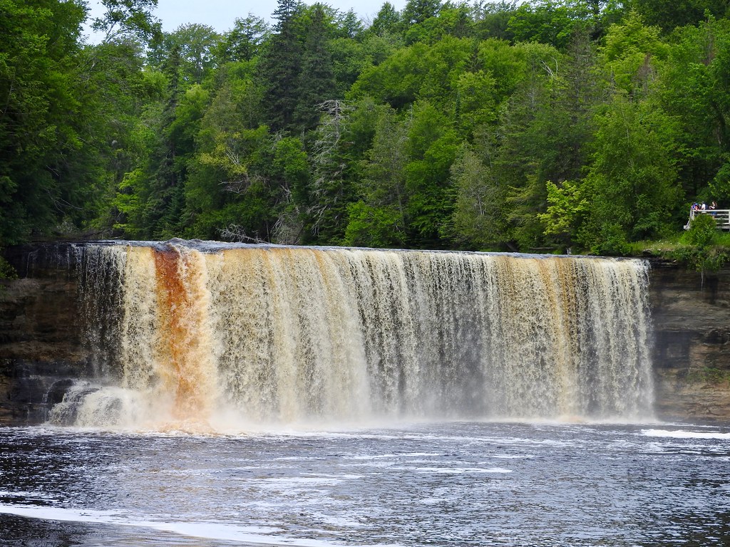
Also, it’s not just one waterfall, it’s several. The upper falls are more dramatic, and drops in a cascade nearly 50 feet (15 metres). The entire river simply plummets over the abyss, straight off the ledge (map). It’s pretty remarkable, kind of like a miniature Niagara.
Trails hug the riverbank so of course I dragged the family to each and every one of the upper falls viewing platforms. Someday they’ll appreciate it.
Lower Falls
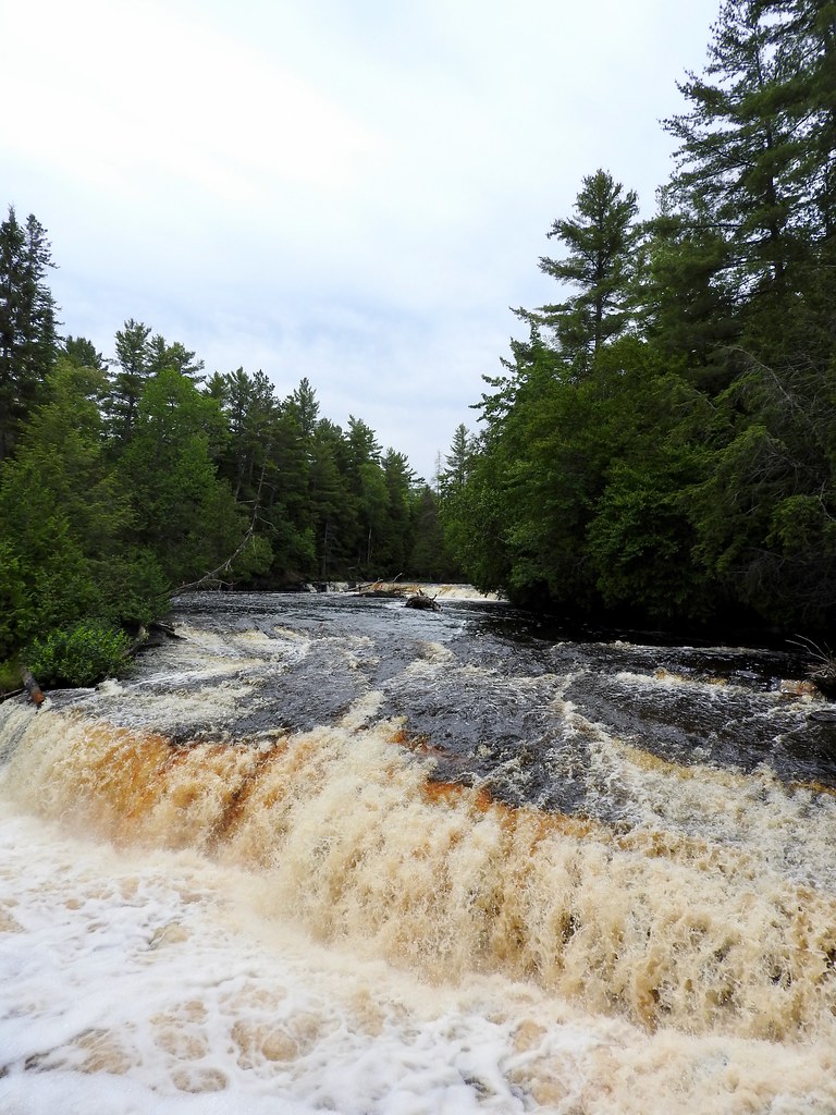
The lower falls are about four miles further downstream within the same expansive park. It’s quite a bit different from the upper falls. In contrast, the lower falls are formed by a whole series of smaller cascades along both sides of an island (map).
The water forms a tranquil pool below the lower falls and many people like to canoe there. Others come for swimming and splashing. Some of the cascades are small enough for people to walk right up to them and feel the water rush by. That made it distinctly different than the upper falls where that would be reckless.
I wish we could have stayed longer. With more time I’d hike the trail between the falls. There’s even a shuttle to carry hikers back if they don’t want to commit to an eight mile out-and-back.
GarLyn Zoo
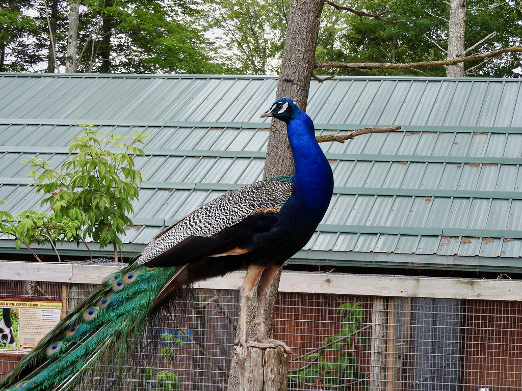
Well, of course we weren’t going to escape a zoo adventures on this trip. Not with a kid who’s pursuing a university degree in zoology. So we stopped at the only place of its kind on the Upper Peninsula and probably the only facility within a hundred miles.
The GarLyn Zoo sits in a fairly remote spot about 40 miles west of the Straits of Mackinac (map). That puts it in reasonable proximity for day-tripping tourists pulled into Mackinac’s orbit. It drew a decent crowd on a summer weekday when we visited, but thankfully not too overwhelming. This attraction certainly won’t fill an entire day so it’s nice to combine it with other activities along the northern Lake Michigan shoreline.
A Point of Significance
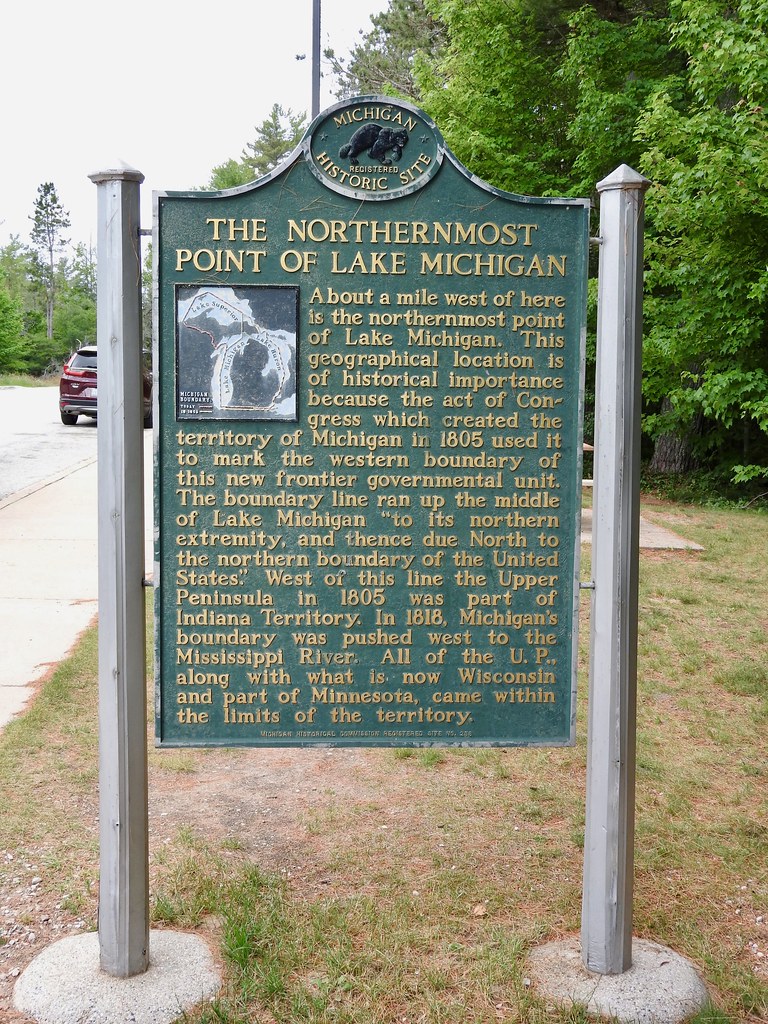
Well, one of those activities I didn’t know about ahead of time, and in fact I didn’t even know it existed. We grabbed a takeout lunch and decided to eat al fresco at one of the highway pullouts. Michigan provides an abundance of such scenic stops along the banks of the Great Lakes, and that seemed a lot more attractive than the local greasy spoon. So we pulled over and… suddenly here we were at the Northernmost Point of Lake Michigan (map). It was a mighty fine lakefront view from our picnic table, too.
The actual spot was about a mile away, but hey, that’s close enough for our needs! The signage went on to explain that a boundary once ran through the same point so that made it doubly interesting.
Mystery Spot
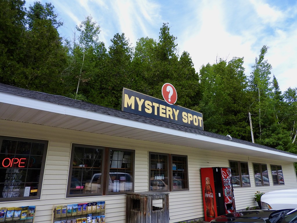
There was a graphic floating around various social media this summer that listed the “most overrated” attraction in each U.S. state. For Michigan, it was the Mystery Spot near St. Ignace (map). Some may call it a Tourist Trap but I still love these kinds of places. Cheezy? You bet! Hokey? Of course! But that’s the attraction. Just go. You know you want to.
I mean the mystery isn’t really all that mysterious. A series of rooms built on angles makes it appear like objects defy gravity. It’s disorienting because visual queues don’t match natural gravitational forces. Walking through these rooms feels weird and disorienting. But if that isn’t appealing enough then the Mystery Spot also offers ziplines, mini-golf and a maze.
Castle Rock
Castle Rock is another longstanding tourist attraction near St. Ignage (map). It’s hard to miss it because it overlooks Interstate 75, clearly visible from the roadway.
It’s been a local geographic landmark for as long as people have lived here. The native Ojibwa used it as a lookout because of its commanding view of Lake Huron and its shoreline. It became a bona fide tourist attraction sometime in the 1920’s when automobile travel rose in popularity.
The Rock
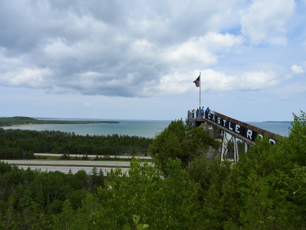
It’s a sea stack formed of limestone and it once sat within an ancient lake much larger than current Lake Huron. Wave action eroded the surrounding terrain as the massive lake slowly receded. The harder composition of Castle Rock remained behind and now it towers some 200 feet (59 metres) above everything else.
It’s been all touristed-up, with a staircase going all the way to the top. This may have tainted it from a geological perspective I suppose, but I couldn’t argue with the view. We could even see the entirety of Mackinac Island from up there (part of it is visible on the right side of the photo on the lake’s horizon).
Best of all it only cost a buck, a true bargain for an area known for targeting tourists. It had a huge gift shop though, and I suspect that’s probably where they made up the difference. They used the towering rock as an easy way to attract people into the store.
A Bonus Bunyan
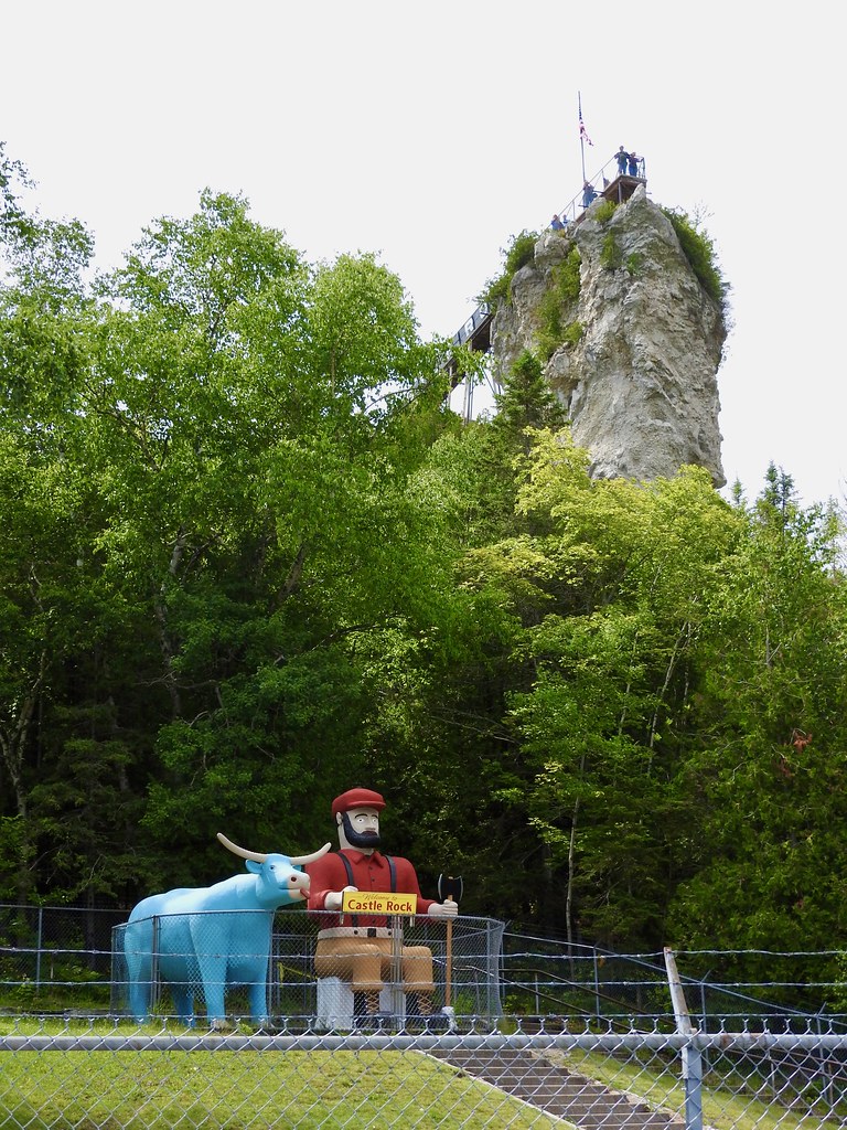
In an earlier article I mentioned a Paul Bunyan encounter. A similar thing happened at Castle Rock too. However, this one included an additional artwork, a giant Babe the Blue Ox. It seems they had to put a chain link fence around the whole thing though. I can only guess at the indignities Paul and Babe must have endured before the fence. People sitting on Paul’s lap, riding on Babe’s back or goodness knows what else.
Articles in the Mackinac’s Orbit Series
- Up North
- Counting Fingers
- Sault Ste. Marie
- Petoskey
- Eastern U.P.
- Mackinaw City
- St. Ignace
- Town of Mackinac Island
- Lake Shore Road
- Into the Highlands
- What’s Brewing?
See Also: The Complete Photo Album on Flickr.
Leave a Reply