
A typical tourist on Mackinac Island sticks pretty close to town. Maybe they’ll take a carriage tour inland or head over to the golf course. Still others may venture around the perimeter on a bicycle along Lake Shore Road. But there are other spots that get less attention.
I wouldn’t call any of them “obscure” or “secret” in any sense because people crawl over every square inch of this island. However they tend to be quieter and it’s a different perspective from the island’s higher elevations, particularly away from the lakeshore.
The kid and I took our bicycles around to the north side and over to British Landing Road. Then we rode uphill along the island’s elevated spine while stopping at points along the way. As a result, sights described in this installment align roughly north to south.
Friendship’s Altar

Well, let me back up a bit. We began at British Landing but the first sight didn’t require a bicycle. We hiked a short path from the nature center up to a sea stack called Friendship’s Altar (map). Yes, another sea stack! I kept bumping into those everywhere during the week including another one later in the ride.
There’s a wooden observation tower nearby. I think it’s been there for awhile because it was kind-of rickety and the view wasn’t all that great. It seemed like trees might have been trimmed or cleared at one time and regrown over time. But that didn’t stop us from climbing the tower anyway.
Croghan Water

Then we hopped on our bikes and officially started our uphill journey using British Landing Road. First we arrived at Croghan Water, a seasonal marsh (map). Rainwater collects in this depression with no way to drain out. So the basin fills as it rains and dries when it doesn’t. Typical marsh features like frogs and cattails thrive here. We also saw a blue heron wading along the bank. This may be the only ephemeral marsh anywhere on Mackinac Island although I didn’t look for others.
Airport

The airport is hardly obscure and it takes up a solid chunk of real estate atop Mackinac Island (map). It’s not like they can hide an airport or the airplanes landing or taking off, although it’s mostly invisible to those in town. The average visitor probably won’t see it either unless they’re heading to a nearby golf course. The airport is a couple miles from town so your taxi will be a horse-drawn carriage if you happen to land here.
Sugar Loaf
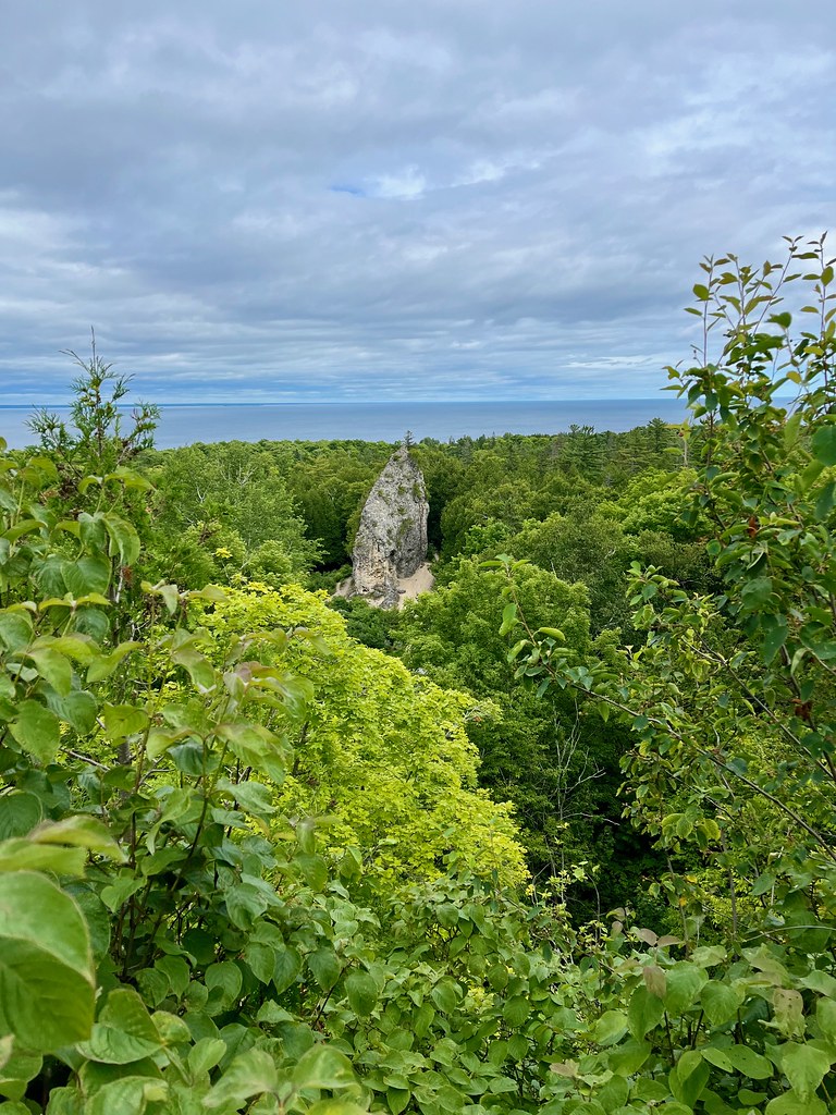
Here’s the other sea stack we saw that day, a monolith known as Sugar Loaf (map). Ten thousand years ago, when the lake was higher, this was a small islet disconnected from the rest of Mackinac.
We rode down to the base of Sugar Loaf and it seemed pretty impressive (photo). However, I like this view from a nearby ridge better. It reminded me of a Mayan ruin rising out of the rain forest.
Island Cemeteries
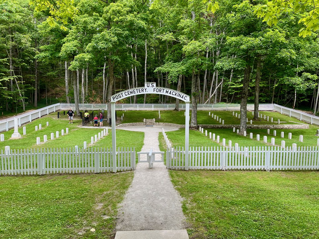
Mackinac Island is so completely tourist that one tends to forget about the people who live there permanently, as they’ve done for centuries. And of course some of them die there. A cluster of three small cemeteries occupies space in the south central interior.
My favorite one was the U.S. Post Cemetery for old Fort Mackinac (map). It is maintained by the National Cemetery Administration of the U.S. Department of Veterans Affairs. Many of the interred are lost to history and may include soldiers from the War of 1812.
Skull Cave

They sure have a thing for hyperbole on Mackinac Island. First there was the dreadfully sounding Devil’s Kitchen that turned out to be decidedly ho-hum. Now we encountered an underwhelming Skull Cave (map). Like, that’s it? That little dent in the rock?
Let’s return to the notion of “legends” again. According to a sign at the site, some British guy hid there during a Native American rebellion in 1763. He was forced to remain in the cave overnight even though it was littered with human bones. Apparently it was used as a burial spot during pre-Columbian times.
Fort Holmes
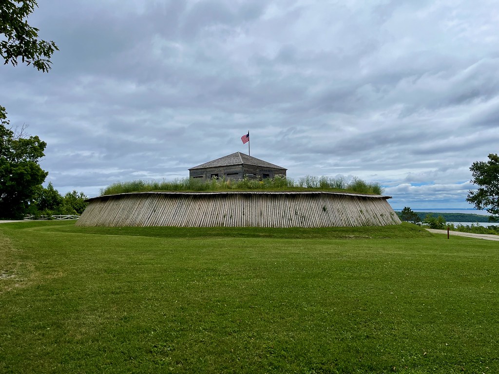
After the British captured Fort Mackinac in the War of 1812 when they marched up the backside of the island, they wanted to prevent Americans from doing the same thing. So they built a redoubt at the island’s highest elevation and kept a watchful eye open for invaders (map).
They named it Fort George for their king, and Americans renamed it Fort Holmes after the war when Mackinac Island returned to U.S. control. It didn’t have a purpose during peacetime so they soon abandoned it. The structure standing today is a reconstruction.
I was hoping this might be the Mackinac County highpoint because county highpointing is a thing. However, it is not. It’s merely the island highpoint. But that still meant we had to ride our bicycles uphill about 300 feet to get there (Lake Huron at 577 ft. vs. Fort Holmes at 889 ft.). The view made it all worthwhile.
Lime Kiln Ruins

On the other hand, these ruins of an old lime kiln might actually qualify as obscure. My kid hiked the Lime Kiln Trail earlier in the summer and searched for the actual lime kiln. It shouldn’t be too difficult because the trail is only two-tenths of a mile, right? And there did seem to be a man-made pile of rocks in the underbrush (map). Could that be it? Nothing else seemed to match.
Much of the island is composed of limestone so it made sense to build a kiln. That way they’d have a ready supply of lime for cement or concrete or other purposes. They started doing that in the early 19th Century.
It seemed vaguely interesting so I asked to see it. We got off our bikes and hiked a short way into the woods to what looked like crumbling stonework. I couldn’t tell if it was a former kiln or not. However, if it is, this might be the only modern photograph of the ruins on the internet.
Somewhere in Time Gazebo
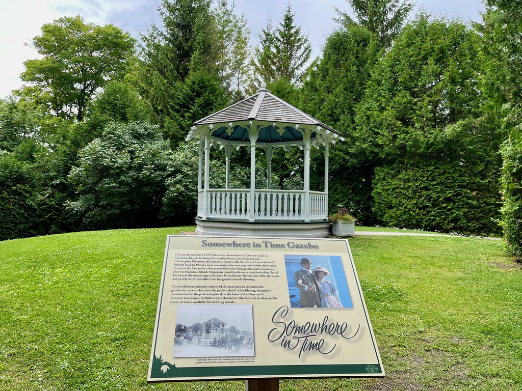
The tree along Lake Shore Road wasn’t the only remnant of the 1980 movie “Somewhere in Time” left on Mackinac Island. There was also the gazebo (map). However, the gazebo wasn’t an existing island feature like the famous tree or the Grand Hotel itself. It was a prop built specifically for the movie.
The movie scenes were filmed at a different location. Eventually the gazebo was moved to this spot after bouncing around to a couple of different places over the years. Nonetheless, if anyone wants to get married at the “Somewhere in Time” gazebo, it’s available for the right price.
Robinson’s Folly

We also stopped at Robinson’s Folly, at the top of a cliff near the Mission Point Resort (the red roofed buildings in the photo). Lake Shore Road with its cyclists appears down there too. It sort-of marks the southeast corner of the island (map).
The outcrop got its name from Daniel Robertson, a British captain who commanded Fort Mackinac in the 1780’s. Yes, his name was Robertson even though the formation is now called Robinson’s Folly. An interpretive sign at the spot explained the folly. Let’s understand that folly has several definitions, one of which is “an often extravagant picturesque building erected to suit a fanciful taste.” So Robertson built his folly high atop the cliff to enjoy the view. There was another definition of folly that applied here too. He built it too close to the edge and it fell off.
It felt like our own secret spy perch. We looked down on everybody down below but they were blissfully unaware of our presence.
Articles in the Mackinac’s Orbit Series
- Up North
- Counting Fingers
- Sault Ste. Marie
- Petoskey
- Eastern U.P.
- Mackinaw City
- St. Ignace
- Town of Mackinac Island
- Lake Shore Road
- Into the Highlands
- What’s Brewing?
See Also: The Complete Photo Album on Flickr.
Leave a Reply