
We took only one substantial day-trip during the week. It followed a loop focused on Sleeping Bear Dunes designed to captured as many counties along the way as possible.
Obviously, I wanted to see more than big piles of sand in return for a 270 mile (435 kilometre) drive. I consulted my article map for Michigan and noticed a big blank spot. It pretty much overlapped with the intended target area. More than ten years of articles and nothing focused there? That seemed odd, I figured although I soon determined the reason. Precious little geo-oddity goodness actually existed there.
I scoured every mile of the route in Google Maps in exhaustive detail. I also consulted Roadside America and Atlas Obscura, noticing the same handful of minor attractions that I’d uncovered on my own. Unfortunately I didn’t find anything truly unique. As a result, what I ended up visiting had already been discussed previously by one or both sources. Hopefully I’ll have at least a slightly different take.
American Legion Armaments
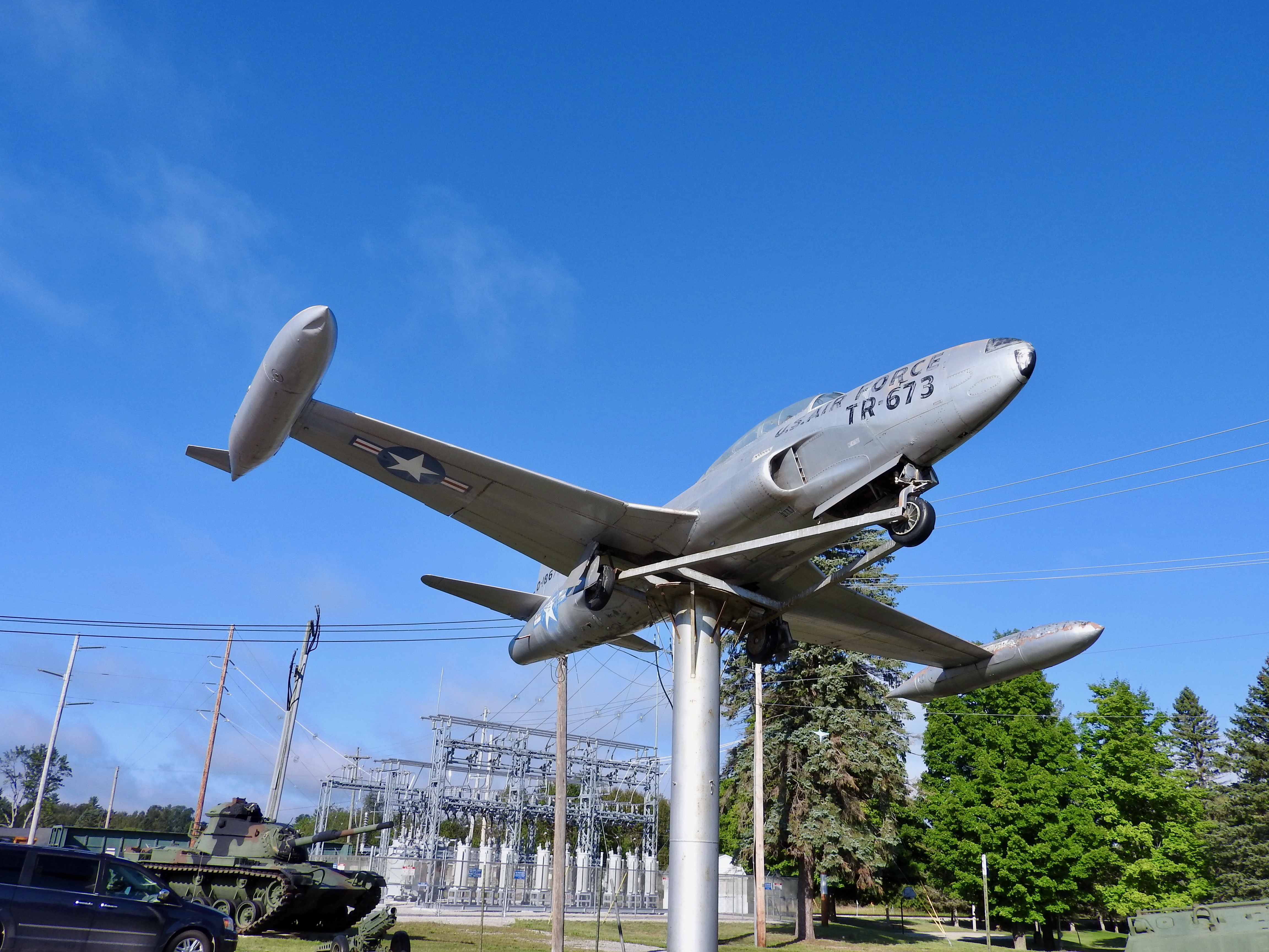
We stopped first in Grayling at American Legion Post 106 (map). That might seem like an unusual choice and I wouldn’t disagree. Essentially, I wanted to see their military hardware display next to the parking lot. The Intertubes identified the jet as a Lockheed T-33 Shooting Star (a trainer) and one of the two tanks as an M4 Sherman Tank. I couldn’t find a reference to the other tank. The Post had several other smaller doodads on its lawn as well.
Ordinarily I probably wouldn’t stop for this. Even so, we need to appreciate what comes along when facing slim pickings. I did enjoy the few minutes it took to stop and snap a few photos.
National Trout Memorial

A similar notion came to mind when we rolled through Kalkaska. Actually I take that back. I’d probably stop for a giant trout fountain on any trip, anywhere, anytime (map). Just look at it! Glorious. I want one for my front yard.
Kalkaska considers itself one of the premier trout fishing destinations in the nation. It started a National Trout Festival in 1933 that continues to this day. Well, except for this year because of the COVID-19 pandemic. Anyway, you get the point. Locals and visitors alike take fishing seriously in the hinterlands of Michigan.
Officially the city of Kalkaska called this fountain/statue the “National Trout Memorial.” It also went by several nicknames including the Fisherman’s Shrine, Trent the Trout, and more obviously The Big Trout Fountain. I don’t know why they considered it a memorial. Did it memorialize trouts hooked and cooked, or old anglers who pursued them?
Wayside Chapel

The return loop provided one more roadside attraction, the tiny Wayside Chapel outside of McBain (map). I must have started a subconscious thing for tiny churches because I’ve stopped at one before. This one seemed even smaller than the one I visited in West Virginia in 2016! I’ll have to wait and see if this develops into another list of things I pursue and track.
The chapel included space for maybe five people; four single-person pews and a pulpit. Even so, I wondered how often anyone preached to a full house there. The parking lot, on the other hand, could probably fit twenty cars or a couple of buses. It all seemed rather paradoxical. I’m pretty sure that loaves and fishes figured into this equation somehow.
The Tridge

We stopped at the Tridge a couple of days later, about an hour away from our home base. Mostly I wanted to capture two more uncounted counties. Fortunately, the Tridge provided a nice opportunity to do that so it became my anchor destination.
How might I describe the Tridge? I struggled to put it into words although the photograph gets the point across. Concisely, it’s a footbridge that allows people to go in three separate directions rather than the typical two. It spans the point where the Chippewa River joins the Tittabawassee River in Midland (map). Municipal parks abut two of the legs and a farmer’s market sits at the base of the third.
I arrived on a rainy afternoon so the best view seemed to be beneath the Tridge. At least I could stay dry under there. I wish I could have spent more time exploring though. The parks looked really nice. However, the weather really made walking about unpleasant. Naturally, the rain stopped and the clouds parted as soon as I started driving back to our base. Isn’t that always how it works?
On the Long Drive Home
I kind of cheated here on the last two sites. They didn’t have anything to do with Michigan. Rather, they became targets of opportunity on our drive back to Virginia. I’m talking about rest stops. This wouldn’t be the first time rest stops appeared on Twelve Mile Circle although I’m not really sure why I took the photos. Boredom, perhaps?
South Midway Travel Plaza
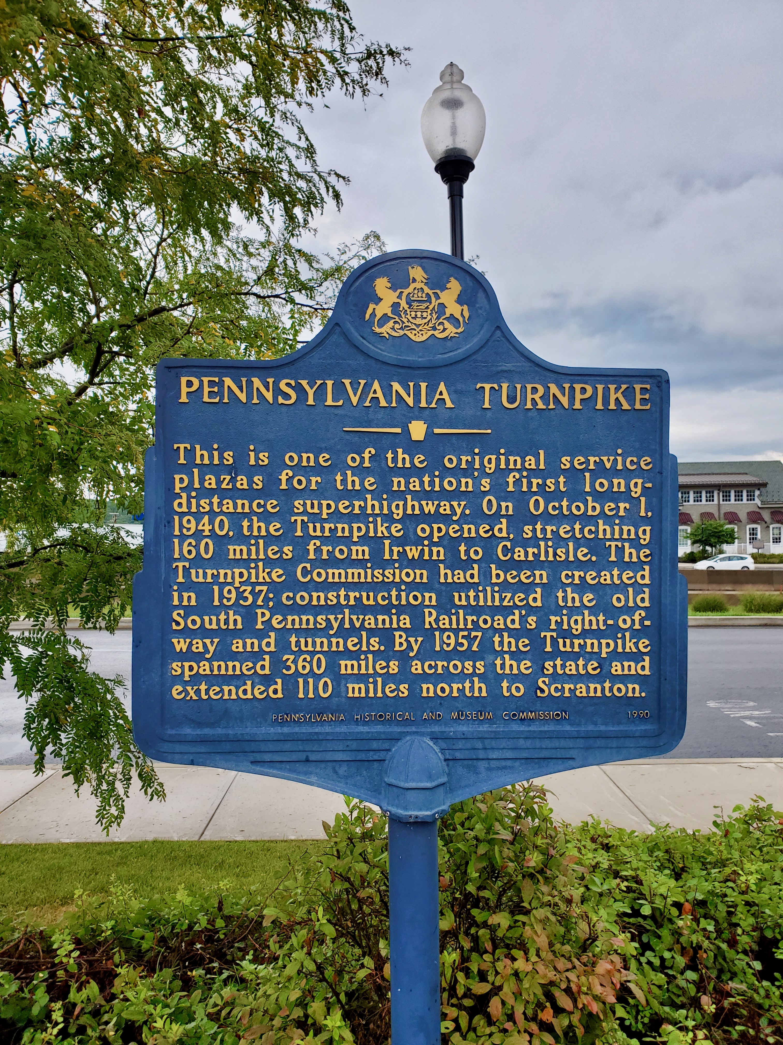
We stopped at the South Midway Travel Plaza on Interstate 76 — the Pennsylvania Turnpike — near Bedford (map). I did this because I refused to stop in Breezewood, where we had to switch to I-70. I never stop in Breezewood and I never will because I absolutely will not reward their greediness. This is why:
Thus, anyone traveling between I-76 and I-70 has to get onto a surface street for a half-mile and pass a gauntlet of gas stations, restaurants and budget motels. The traffic lights frequently cause huge backups there. All so Breezewood — which actively prevented direct access between the Interstates — can try to extract cash from passing vehicles. I consider this my own personal boycott.
South Mountain Welcome Center
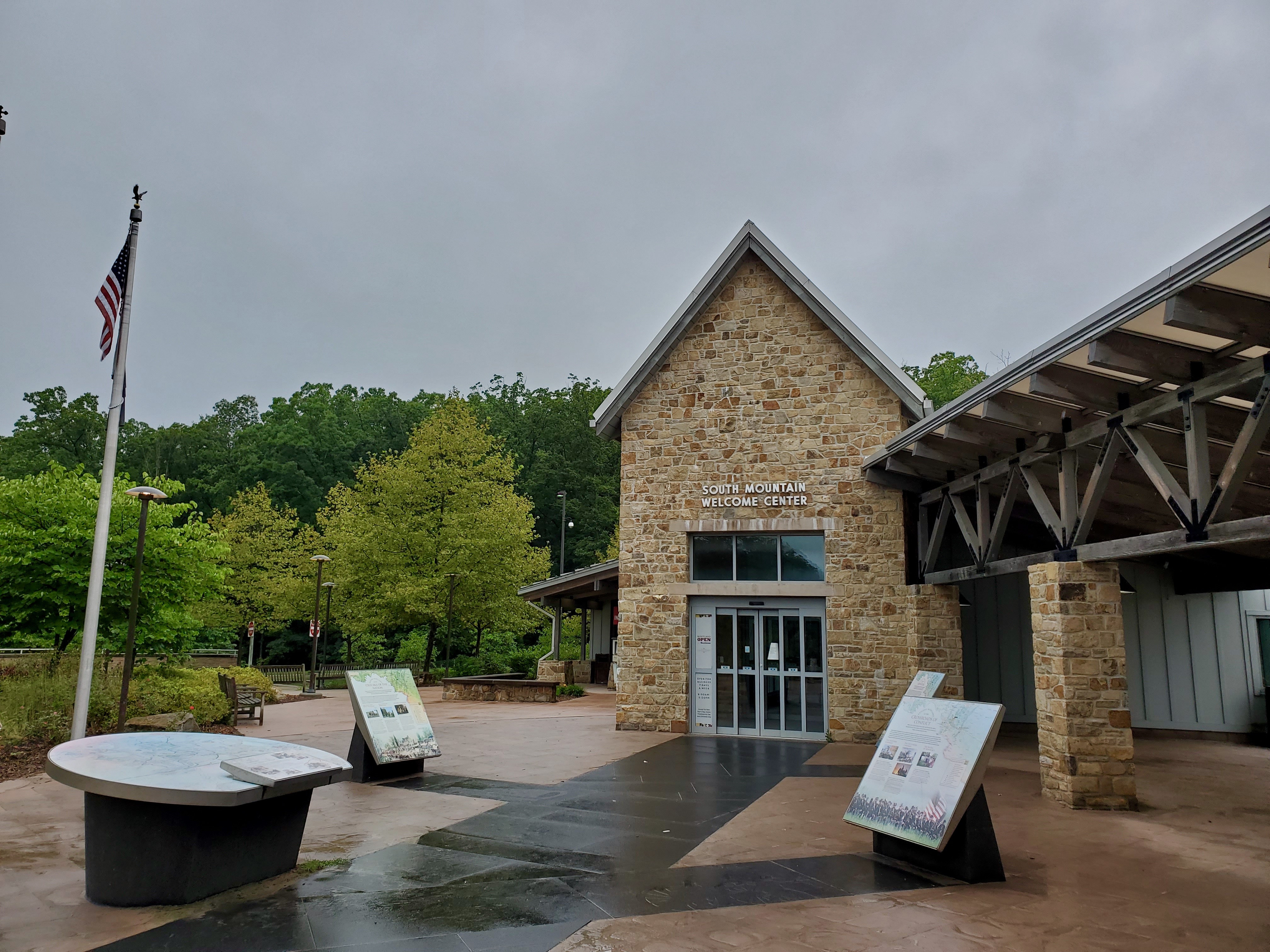
Further down the road on I-70 we stopped at the South Mountain Welcome Center between Hagerstown and Frederick, Maryland (map). We stop here regularly on road trips because it’s the last place to do so before getting into the thick of DC-area traffic. Everybody better take advantage of this final opportunity because, after this, we don’t stop for anything. And I mean anything.
Articles in the Exploring the Mitten Series
See Also: The Complete Photo Album on Flickr
Leave a Reply