
Every trip seems to end too quickly. We soon hit the final leg of our northern West Virginia odyssey and headed home. Two uncaptured counties remained on the itinerary, Taylor and Tucker. They formed doughnut holes on my map and they needed to be removed. Oh, how I hated those little white splotches. That completely irrational itch directed my motivation during the waning hours.
This also set a course for an amazing array of roadside attractions and geo-oddities. They clustered near a spot where West Virginia met the southwestern corner of Maryland’s westernmost county. That would be the “Middle of Nowhere” in layman’s terms.
Smallest Church?

Our Lady of the Pines Catholic Church sat just south of Silver Lake, West Virginia (map). Who could possibly pass up an opportunity to see the “Smallest Church in 48 States?” Lots of people probably, although not me and not on this day. I’ve always been a sucker for oddball attractions.
It definitely fit the definition of small, measuring only 12 by 24 feet (3.6 X 7.3 metres). The interior made room for about a dozen parishioners plus an officiant. It even featured a complete Stations of the Cross with each station separated by barely a few inches. The caretakers deserved credit for creating an inspirational space on such a tiny scale.
I wondered about the 48 states. A plaque on an exterior wall provided a possible explanation: Mr. and Mrs. P. L. Milkint dedicated Our Lady of the Pines to the memory of their parents in 1958. That predated statehood for Alaska and Hawaii so maybe they never updated their claim when the number of states changed.
Did it hold water? Not even close. Many houses of worship made similar boasts and several existed within smaller footprints. Nonetheless, it was a very small church in a gorgeous setting along our direct path and certainly deserved a stop.
Smallest Mailing Office?
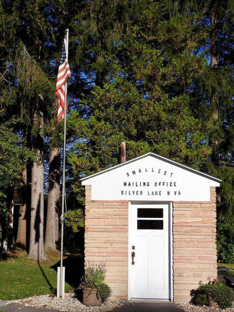
Besides, Our Lady of Pines also features a bonus attraction. Just behind it stood the “World’s Smallest Mailing Office.” I went inside. It featured a service window and a number of personal mailboxes, a mail slot and everything else one would expected in a post office all stuffed into a compact space (photo). However, it didn’t register as the smallest postal facility even in the United States. That honor fell to Ochopee, Florida as described in an earlier Twelve Mile Circle article, Going Postal.
I think Mr. and Mrs. P. L. Milkint simply liked to build miniature structures. I could appreciate that. People might not stop if the sign simply said “smallish church and tiny post office.”
Maryland Highpoint
Less than a mile farther south on US Route 219, the highway shoulder widened where a sign marked a trailhead. We were in West Virginia, however the trail lead to the Maryland highpoint at Hoye-Crest, 3,360 feet (1,020 m). Oddly, the greatest elevation in Maryland could be approached best from a neighboring state.
The path followed old logging roads across private property to the top of Backbone Mountain, then followed the ridge into Maryland to the highpoint (map). It wasn’t particularly arduous, rising about 700 vertical feet (215 m) over the mile-long trek. I prefer drive-up highpoints because I’m lazy. Even so, I didn’t have any trouble with this one.
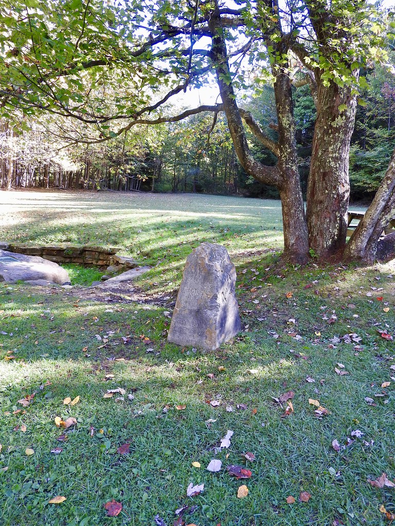
Backbone Mountain hid a couple of additional features worth noting. The Eastern Continental Divide ran directly along the ridge. A glass of water poured there would flow either towards the Youghiogheny River and eventually into the Gulf of Mexico or towards the North Branch of the Potomac River and eventually into the Atlantic Ocean. Also the border between West Virginia and Maryland bisected the ridge so we visited Border Marker No. 3 along the trail (photo).
I still didn’t count myself as an official Highpointer although I’ve managed to visit a few of the easier ones. The list at this point included Connecticut, Delaware, Maryland, New Hampshire, New Jersey, North Carolina, Rhode Island, Tennessee, and the District of Columbia.
Fairfax Stone
Just a few miles farther south down the road appeared the entrance to Fairfax Stone State Park. King Charles II bestowed a substantial land grant reaching out to here in 1649. He defined a western boundary running from the headwaters of the Potomac River to the headwaters of the Rappahannock River in what was then the colony of Virginia.
Nobody bothered to survey the line for another century because of its extreme isolation. Eventually ownership passed to Thomas Fairfax, 6th Lord Fairfax, who decided to mark his domain in 1746. He commissioned Peter Jefferson, father of future president Thomas Jefferson, to set a line between those points.
Jefferson’s marker on the North Branch of the Potomac came to be known as the Fairfax Stone, the source of the Potomac watershed. Later, others determined that the South Branch was actually the true source of the river although boundaries were already set by then. The Fairfax Stone remained (and still remains) the key marker. The state of West Virginia called it “as near as anything to being a cornerstone of the entire state.”
The Fairfax Stone also figured prominently in a US Supreme Court case, Maryland v. West Virginia 217 U.S. 1 (1910). It defined the longitudinal separation between the states. Ironically the stone — actually a replacement because vandals destroyed the original — no longer touched Maryland. The North Branch took a brief western jog at the stone. Maryland began about a mile farther north after the court decision, where the river curved back to the east and crossed the appropriate line of longitude (map). It still marked the Grant, Preston, Tucker County tripoint in West Virginia, though.
A Growing Appreciation
Before I started counting counties in earnest I’d only been to the outskirts of West Virginia plus a couple of whitewater rafting trips. Since then I’ve completed four specific trips nibbling away at places I’d not yet visited. I’ve come to enjoy the state’s mountainous terrain, hidden corners and gracious people. More than anything, these trips allowed me to look past hillbilly stereotypes to appreciate the state on its own merits. That’s what traveling is all about. I do plan to continue returning to West Virginia even after I finish the final swatch and capture its remaining counties.
Articles in the Counting West Virginia Series:
See Also: The Complete Photo Album on Flickr
Leave a Reply