
There are 100 Counties in North Carolina – “The Tar Heel State“
Also be sure to see my United States County Counting Page for the rest of the states.
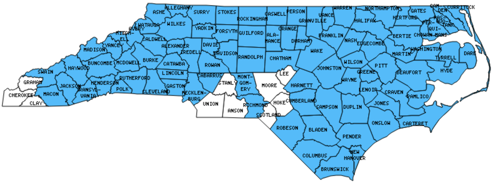
I have visited 90 Counties = 90.0% of Counties in North Carolina
Counties visited are colored-in; counties still needing to be visited are blank. Map created using Mob Rule.
Twelve Mile Circle Articles Featuring Places in North Carolina
Markers designate the North Carolina locations featured in Twelve Mile Circle articles.
Counties in North Carolina
Below are the 100 counties in North Carolina. Although infrequent, counties sometimes do change so please let me know if any of this information is out of date and I will update it. Those counties that I have visited are highlighted in Red. Readers can also link to any articles manually in this section if the map isn’t working.
- Alamance: Random Hills
- Alexander
- Alleghany: Alleghany/Grayson Border
- Anson
- Ashe
- Avery: Famous Louise’s Rock House
- Beaufort: Ten Seats in North Carolina; Bayview – Aurora Ferry
- Bertie
- Bladen
- Brunswick: Orton Plantation
- Buncombe: Where They Lived as Children; Biltmore Estate; Highland; WNC Nature Center; Funkatorium; One World; Pack Square Park
- Burke: Linville Falls; Famous Louise’s Rock House
- Cabarrus
- Caldwell
- Camden: Great Dismal Canal
- Carteret: Beaufort or Badminton; Ten Seats in North Carolina; Sunrise and Sunset Over Water; Salter Path; Beaufort Tour; Fort Macon; Battle of Newport Barracks; Wildlife
- Caswell
- Catawba
- Chatham
- Cherokee
- Chowan: Smallest county in North Carolina (173 square miles): Roanoke River Lighthouse
- Clay
- Cleveland
- Columbus
- Craven: Hawaii on the Mainland; Cherry Branch – Minnesott Ferry; Birthplace of Pepsi Cola; Tryon Palace; Battle of New Bern
- Cumberland: Mash House Brewery & Chophouse
- Currituck: Currituck Beach Lighthouse; Weeping Radish Farm Brewery; Bordersplit
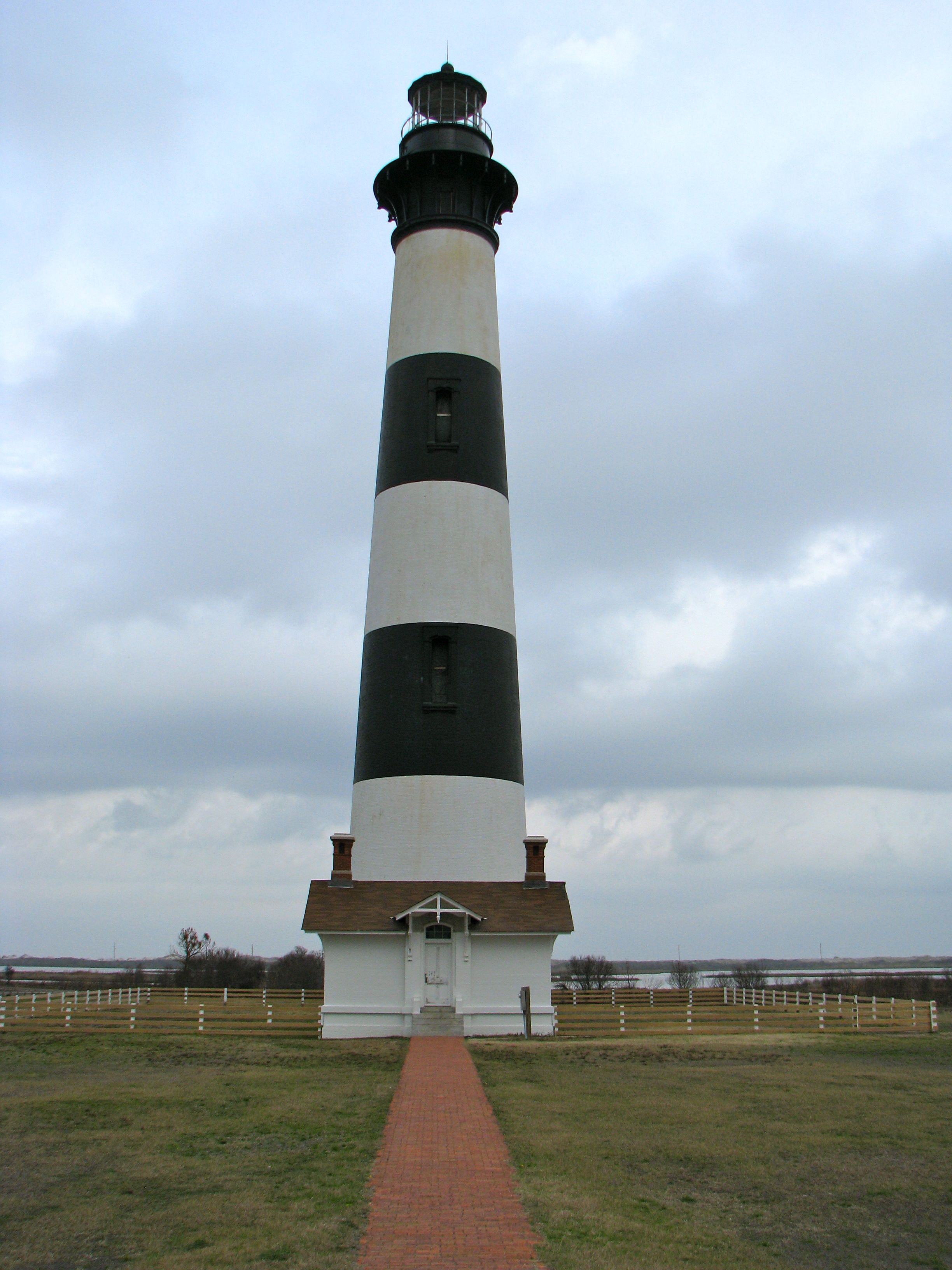
- Dare: Duck; Bodie Island Light Station; Cape Hatteras Light; Fort Raleigh National Historic Site; Hatteras-Ocracoke Ferry; Outer Banks Brewing Station; Wright Brothers National Memorial
- Davidson: Random Woods; Welcome; Quad County Towns
- Davie
- Duplin
- Durham: Steve & Clark’s Brew Pub and Sausage Co.; Triangle
- Edgecombe
- Forsyth: Quad County Towns
- Franklin
- Gaston
- Gates: Every Cardinal Direction
- Graham
- Granville
- Greene
- Guilford: Sports Facilities I Never Imagined; Quad County Towns; High Level; Random Woods
- Halifax
- Harnett
- Haywood
- Henderson: Sierra Nevada
- Hertford
- Hoke
- Hyde: Hatteras-Ocracoke Ferry; Ocracoke Light Station; An Extreme Definition of Southern; Union Jack over the USA
- Iredell
- Jackson: Harrah’s Cherokee Casino
- Johnston
- Jones
- Lee
- Lenoir
- Lincoln: Rock Springs Campmeeting
- Macon
- Madison: Ancient River; Hot Springs Everywhere
- Martin
- McDowell: Linville Caverns; Famous Louise’s Rock House
- Mecklenburg: Largest county population in North Carolina (695,454 people in 2000 Census); Municipally Owned Telephone; Caro-what?; Noble Layers
- Mitchell: Geo-BREWities
- Montgomery
- Moore
- Nash
- New Hanover: Fort Fisher Beach; Fort Fisher Ferry; Basin Trail; Wilmington Riverwalk; WW2 Ammunition Bunker; USS North Carolina
- Northampton
- Onslow: Undignified Floods
- Orange: Carolina Brewery; Morehead Planetarium Sundial
- Pamlico: Cherry Branch – Minnesott Ferry
- Pasquotank: Museum of the Albemarle; Ghost Harbor Brewing; Waterfront Park
- Pender
- Perquimans: Newbold-White House
- Person
- Pitt
- Polk
- Randolph: Quad County Towns
- Richmond
- Robeson: Largest county in North Carolina (949 square miles): I-95 Rest Stop
- Rockingham
- Rowan
- Rutherford: Ten Seats in North Carolina; Lake Lure; Chimney Rock
- Sampson: Thanksgiving Towns
- Scotland
- Stanly
- Stokes
- Surry
- Swain: Literal Roads to Nowhere; Oconaluftee Islands Park; Museum of the Cherokee Indian; Clingmans Dome; Mountainous Claims
- Transylvania: Oskar Blues; Sassafras Mountain:
- Tyrell: Smallest county population in North Carolina (4,149 people in 2000 Census); A Tyrrell County Highpoint.
- Union: Go South to Go North
- Vance
- Wake: Southend Brewery & Smokehouse; Land of Disco; Carnage, Slaughter and Mayhem; A Tale of Three Ridges; Low Clearance; Noble Layers
- Warren: Dueling Portmanteau Placenames
- Washington: Ten Seats in North Carolina
- Watauga: Lost Province
- Wayne
- Wilkes
- Wilson
- Yadkin
- Yancey: Mount Mitchell
Quick Facts About North Carolina
- Location: South Atlantic United States. See map above.
- Size(1): 48,618 square miles. North Carolina is the 29th largest state. The next larger state is Alabama and the next smaller state is New York.
- Population(2): 10,383,620 people. North Carolina is the 9th most populous state. The next more populous state is Georgia and the next less populous state is Michigan.
- Population Density: 213.6 people per square mile. North Carolina is the 15th most densely populated state. The next more densely populated state is Virginia and the next less densely populated state is Georgia.
- Bordering States: North Carolina shares a border with 4 states: Virginia; Tennessee; Georgia and South Carolina
- Admission to the Union: November 21, 1789. North Carolina was the 12th state admitted to the Union, after New York and before Rhode Island.
- Capital: Raleigh.
- Highest Point: 6,684 feet at Mount Mitchell. See SummitPost’s Mount Mitchell page.
- Lowest Point: Sea Level at the Atlantic Ocean.
- Government website: North Carolina Government Portal.
- Official Tourism website: Visit North Carolina.
- Still not enough? See Wikipedia’s North Carolina page.
Sources:
(1) Wikipedia: List of U.S. states and territories by area. Land area only.
(2) Wikipedia: List of states and territories of the United States by population. Estimated population on July 1, 2019.
Leave a Reply