
There are 133 Counties / Independent Cities in Virginia – “The Old Dominion“
Also be sure to see my United States County Counting Page for the rest of the states.
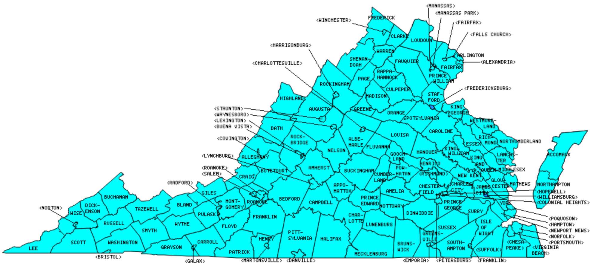
I have visited 133 Counties / Independent Cities = 100% of Counties / Independent Cities in Virginia
Counties visited are colored-in; counties still needing to be visited are blank. Map created using Mob Rule.
Twelve Mile Circle Articles Featuring Places in Virginia
Markers designate the Virginia locations featured in Twelve Mile Circle articles.
Interesting Virginia county trivia
While several states have an independent city embedded within them, Virginia is the only one that makes it a common practice. There are 38 independent cities which are not part of any county, and are considered “county-equivalents” for the decennial census and other statistical purposes.
Counties/Cities in Virginia
Below are the 133 counties and independent cities in Virginia. Although infrequent, counties sometimes do change so please let me know if any of this information is out of date and I will update it. Those counties that I have visited are highlighted in Red. Readers can also link to any articles manually in this section if the map isn’t working.
- Accomack: Accomac; Assateague Island Lighthouse; Belle Haven; Carnival; Chicken Farm; Chincoteague and Assateague; County Line; Locustville Academy; Machipongo River; Off Season; Onancock Town Square; Tangier Island; Tangier Island Ferry; Wachapreague
- Albemarle: Beer Trail; Skyline Drive – Southern District
- Alexandria (Independent City): My Speech; Reverberations of a Doomed Expedition; Trailer Park Nation; Former District of Columbia Boundary Stones; Jones Point Light; Shenandoah Brewing Company; Switching Sides
- Alleghany: Falling Spring Falls; Humpback Bridge
- Amelia
- Amherst
- Appomattox
- Arlington: Smallest county in Virginia and smallest self-governing county in the United States (26 square miles); Four Courts Four Miler; 26 meets 31; Nest of Spies; When Categories Collide!; Where They Lived as Children; Even More Unusual Signs; Highway to Park; Our Lady of the Gas Pump; Memorial Day; Farm to Market; Divine Apartments; GPS and Genealogy; Reversible; History, Geography and Fitness; Spike House for Sale; Geography as Pitcher Plant; A Tale of Three Ridges; My Smallest Park; Arlington County Will Grow,; All Those Modes of Transportation,; Penciling-In Reagan; The John McCain Flight; Abingdon Plantation Ruins; Silly Little Highway; Former District of Columbia Boundary Stones; Fort C.F. Smith; Washington DC Area’s Last Phone Booth; Bardo Rodeo; Blue-N-Gold Brewing Company; Capitol City Brewing Company; Rock Bottom Brewery; Crystal City
- Augusta: Augusta Bump; Skyline Drive – Southern District
- Bath: Appalachian Loop; Taking a Bath
- Bedford
- Bland
- Botetourt: Pronounced HOW?
- Bristol (Independent City): Quadripoint Boundary Cross
- Brunswick
- Buchanan
- Buckingham
- Buena Vista (Independent City)
- Campbell
- Caroline: Last Stand at Garrett Farm; Bowling Greener; No more rest?; Ladysmith
- Carroll
- Charles City County: Oldest Continuous Businesses
- Charlotte: Virginia Smoking Ban
- Charlottesville (Independent City): Three Notches; Smoots and Potrzebies; No Names and Nameless; Carnage, Slaughter and Mayhem; Blue Ridge Brewing Co.; Starr Hill Restaurant & Brewery
- Chesapeake (Independent City): Bordersplit; Great Dismal Canal; Lake Drummond
- Chesterfield: Chesterfield Tendril
- Clarke: Dinosaur Land; Wine Adventure
- Colonial Heights (Independent City)
- Covington (Independent City)
- Craig: Craig County Public Library
- Culpeper: Journey Through Hallowed Ground
- Cumberland
- Danville (Independent City)
- Dickenson: Macaca Moment; Stateline Overlook
- Dinwiddie
- Emporia (Independent City)
- Essex: Land of Disco
- Fairfax: Largest county population in Virginia (969,749 people in 2000 Census); Fairfax Enclave; Former District of Columbia Boundary Stones; Ghost Towns; Great Falls Park; Herndon Station; Innovation Center Station; Just Keep Turning; Lucky 7 & the Ghost Kid; Name That Smell; National Air and Space Museum, Udvar-Hazy Center; Real Virginia Border; Reston Town Center Station; State Nickname Streets; The Other Mount Vernon; The Spots Not Covered; Sweetwater Tavern
- Fairfax City (Independent City): Fairfax City Highpoint; Just the -fax, Ma’am
- Falls Church (Independent City): Smallest independent city in Virginia and smallest “county equivalent” in the United States (2 square miles); Railroad Cottages; When Categories Collide!; Not Fusion, CONfusion; Former District of Columbia Boundary Stones; Mad Fox Brewing Company
- Fauquier: The Spots Not Covered
- Floyd: Of Of
- Fluvanna
- Franklin
- Franklin (Independent City)
- Frederick
- Fredericksburg (Independent City)
- Galax (Independent City)
- Giles: Sinking Creek Bridge
- Gloucester
- Goochland
- Grayson: Grayson Pinch; Of Of; Alleghany/Grayson Border
- Greene
- Greenesville
- Halifax: Virginia Smoking Ban; Dueling Portmanteau Placenames
- Hampton (Independent City): Tucker Family Cemetery; Fortress Fixation
- Hanover: Williamsville Brewery
- Harrisonburg (Independent City): James Madison University
- Henrico: Pronounced HOW?
- Henry
- Highland: Smallest county population in Virginia (2,536 people in 2000 Census): Devils Backbone; Appalachian Loop
- Hopewell (Independent City)
- Isle of Wight
- James City County: Quadripoint Boundary Cross; Jamestown Field Trip; Jamestown-Scotland Ferry
- King and Queen
- King George: By George
- King William
- Lancaster
- Lee: Remote Southwestern Virginia; Virginia, West of West Virginia; Getting There
- Lexington (Independent City)
- Loudoun: Ashburn Station; Dulles Airport Station; Loudoun Gateway Station; Loudoun Wine Adventure; Old Dominion Brewing Co.; Runway 01L-19R; Selden Island; Vintage 50 Restaurant & Brew Lounge; Warp Drive; Washington-Dulles International Airport Panorama; White’s Ferry
- Louisa
- Lunenburg
- Lynchburg (Independent City)
- Madison
- Manassas (Independent City): Manassas Highpoint
- Manassas Park (Independent City): Manassas Park Highpoint
- Martinsville (Independent City)
- Mathews
- Mecklenburg
- Middlesex
- Montgomery: Bull & Bones Brewhaus & Grill
- Nelson: Beer Trail
- New Kent
- Newport News (Independent City): Land Swap; Revisiting the Swap; Named for Captain Newport
- Norfolk (Independent City): Other State Nickname Thingies; International Capitals in the USA; Pronounced HOW?; Norfolk International Terminals; Elation Brewing; Virginia Zoo
- Northampton: Move the Road; Silver Beach – East Coast Sunset over Water; Chesapeake Bay Car Ferries; For Aficionados of Counties; County Line
- Northumberland: Tangier Island Ferry; Longest county name (14 characters) – tied with Northumberland County, Pennsylvania.
- Norton (Independent City): Smallest independent city population in Virginia and the United states (3,904 people in 2000 Census).
- Nottoway
- Orange
- Page: Hazy Hedge Maze Memories
- Patrick
- Petersburg (Independent City): Plank Roads
- Pittsylvania: Largest county in Virginia (978 square miles).
- Poquoson (Independent City): Lowest Highpoints; Getting to Norfolk
- Portsmouth (Independent City)
- Powhatan
- Prince Edward: Sydney Tentacles
- Prince George: Prince George Exclave; Disputanta
- Prince William: Prince William Enclave; Real Virginia Border; Make a Bee Line; Quantico – The Ultimate Gated Community; Quantico Cascades; Worst Commute in the USA; Triangle
- Pulaski
- Radford (Independent City)
- Rappahannock: Flip-Flopping; Short Distance Namesakes
- Richmond: Not the City; That Other Warsaw
- Richmond (Independent City): Three Notches; The Oddity That Got Away; Named for Captain Newport; Virginia Smoking Ban; Name That Smell; Can You Tell Me How to Get; Richbrau Brewing Company; Legend Brewing; Scott’s Addition
- Roanoke
- Roanoke (Independent City)
- Rockbridge: Natural Bridges
- Rockingham
- Russell
- Salem (Independent City)
- Scott
- Shenandoah: Shenandoah Caverns; Meems Bottom Bridge; Appalachian Loop; Eric Henn Murals
- Smyth
- Southampton: Every Cardinal Direction
- Spotsylvania: My Little Poni; Blue & Gray Brewing Co.
- Stafford: Bull’s Eye
- Staunton (Independent City): Appalachian Loop; Presidential Birthplaces; Pronounced HOW?
- Suffolk (Independent City): Largest independent city in Virginia and the United States (400 square miles); Lake Drummond.
- Surry: Jamestown-Scotland Ferry
- Sussex
- Tazewell: Bluefield on the Border
- Virginia Beach (Independent City): Largest independent city population in Virginia (435,619 people in 2000 Census); Chesapeake Bay Car Ferries; Railroad Ferry; Drive Me Crazy
- Warren: I Just Liked the Photo
- Washington: Quadripoint Boundary Cross; Every Cardinal Direction
- Waynesboro (Independent City)
- Westmoreland: Legalized Gambling in Colonial Beach (1940’s-1950’s); Presidential Birthplaces
- Williamsburg (Independent City): Quadripoint Boundary Cross; A Colonial Capital; Hazy Hedge Maze Memories; Colonial Colleges; Williamsburg AleWerks
- Winchester (Independent City)
- Wise
- Wythe: 81 on 81; Certainly Not Austin
- York: Land Swap; Revisiting the Swap
Quick Facts About Virginia
- Location: Mid Atlantic United States. See map above.
- Size(1): 39,490 square miles. Virginia is the 36th largest state. The next larger state is Ohio and the next smaller state is Kentucky.
- Population(2): 8,517,685 people. Virginia is the 12th most populous state. The next more populous state is New Jersey and the next less populous state is Washington.
- Population Density: 215.7 people per square mile. Virginia is the 14th most densely populated state. The next more densely populated state is Hawaii and the next less densely populated state is North Carolina.
- Bordering States: Virginia shares a border with 5 states: Maryland; West Virginia; Kentucky; Tennessee and North Carolina.
- Admission to the Union: June 25, 1786. Virginia was the 10th state admitted to the Union, after New Hampshire and before New York.
- Capital: Richmond.
- Highest Point: 5,729 feet at Mount Rogers. See SummitPost’s Mount Rogers page.
- Lowest Point: Sea Level at the Atlantic Ocean.
- Government website: Virginia.gov – The Official Commonwealth of Virginia Home Page.
- Official Tourism website: Virginia Is For Lovers: Vacation in Virginia.
- Still not enough? See Wikipedia’s Virginia page.
Sources:
(1) Wikipedia: List of U.S. states and territories by area. Land area only.
(2) Wikipedia: List of states and territories of the United States by population. Estimated population on July 1, 2019.
Leave a Reply