
On the Virginia Side of the Potomac River (2008)
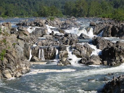
Sitting along the wide, placid shoreline of the Potomac River in Washington, DC, it’s hard to imagine raging rapids crashing through a narrow gorge just 15 miles upstream. Here stand the mighty Great Falls, rushing from those first foothills of the Appalachian Mountains further west (map).
Water descends nearly eighty feet over a series of cascades and chutes in less than a mile. While the height may not seem remarkable compared to some of the world’s tallest, consider that the amassed volume of an entire river watershed compresses and squeezes from 1,000 feet across to less than 100 feet into a slot carved in solid stone. It is truly the steepest and most pronounced fall line on the United States’ Atlantic coastal plain. What it lacks in altitude it makes up for in sheer power, and noise. Gaze upon this scene and discover why early European settlers considered these the Great Falls.
Protected Park Land
The National Park Service preserves this entire area for public enjoyment. It’s called Great Falls Park along the Virginia side of the riverbank, where it’s part of the George Washington Memorial Parkway. Oddly enough it’s a different park on the Maryland side (including the river itself) where it’s part of the Chesapeake and Ohio Canal National Historic Park. Either way, the whole area remains protected.
Things to Do
There are many activities available for a wide range of outdoor interests at Great Falls. The several scenic vistas of the falls themselves are not to be missed. Three large overlooks bring visitors safely cliff-side for spectacular views of the falls far below. There are numerous hiking trails, but none are too challenging and some are downright relaxing. Several are wide and smooth enough for bicyclists and horseback riders to share the trail with walkers. The more adventurous can choose whitewater or rock climbing within designated areas.
We usually start at the Visitors Center, take a look at the falls, and wander along some of the hiking trails. We often bring a packed lunch along. There’s a large field adjacent to the Visitors Center with numerous picnic tables scattered among shade trees.
One word of advice: arrive early on any weekend with nice weather. The parking lot fills up quickly and I’ve seen cars queue-up a good mile or so all the way back to Georgetown Pike. On those days it’s better skip the outing and try again later if you can’t be there well before noon.
Kayaking
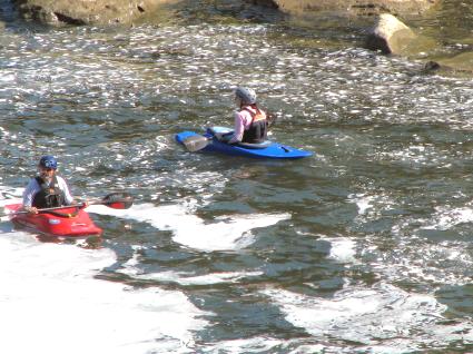
We love watching the kayakers at the base of the falls. The falls themselves are Class 5+ on the International Scale of River Difficulty, which equals “extreme difficulty.” Take a look at the video again and I think you’ll agree that some of the drops are rather intense and violent. Indeed, certain spots may be Class 6, unrunnable, and downright dangerous. Even so, there are expert kayakers who can navigate the falls successfully.
Things are more manageable immediately below the falls and through Mather Gorge. Here the waters rank Class 2-3 which range between novice to intermediate. The folks in this photograph are paddling in those calmer waters below the falls. From this spot they can paddle up into the whitewater, ride around in it for awhile, pull back into an eddy, and enjoy it all over again.
Great Falls has been a popular whitewater spot for decades and there is a long mutually-beneficial relationship between kayakers and the park. Kayakers work closely with the Park Service cooperatively so they can maintain uninterrupted river access. They’ve agreed to follow a number of voluntary rules designed to keep both kayakers and gawkers safe.
Hiking
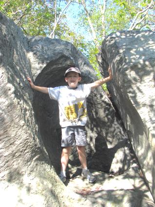
After spending some time at the scenic overlooks we often head down the River Trail atop the cliffs that crown Mather Gorge. There’s some rocky terrain here but our little guys have no problems negotiating it. Simply follow the blue blazes along a well-traveled path and reach some of these less accessible overlooks. Be careful not to leave designated areas. A handful of people drown at Great Falls each year when they slip from the rocks.
Interpretive signs placed at various points explain the topography, geology and ecosystem behind the gorge. Many different loops are available along this stretch so hikers can continue further downriver or cut back towards the interior trails. With kids in tow, we usually hike along the River Trail for about a half a mile (where the majority of the dramatic scenery is concentrated anyway), then cut over to the Patowmack Canal Trail right about where the canal drops down to rejoin the river. This gives the kids a chance to climb around some rocks for awhile but return to the Visitors Center on relatively smooth terrain about the time they get tired.
The Power of Water
The photo above shows one of the many interesting spots along the River Trail. Here the surrounding terrain is a good fifty feet above the river surface atop a sheer cliff. Oddly, this is actually the ancient watercourse of the Potomac. Water flows at its present level far below by carving through solid stone over the last 35,000 years.
The circular indentation on this particular rock is known as a pothole. Smaller rocks and pebbles carried downstream scoured the riverbed. Depressions formed in those spots. Stones and grit caught in roiling waters drove into the depressions, churned repeatedly when conditions were just right, and carved within a circular pattern. Repeated nonstop grinding, year-after-year, caused smoothly polished potholes to appear. This pothole and the rest of the old riverbed remain behind for our enjoyment.
The Patowmack Canal
As if the incredible scenery and geology weren’t enough, the 800 acres of Great Falls Park soak in American history as well, with direct ties to none other than George Washington. The great promise of a new nation lay west towards the continental interior. The prospect of future prosperity would be furthered if only an easy way could be found to connect the Atlantic Seaboard with the Ohio River (and by extension the Mississippi River). However, a long rocky backbone, the Appalachian Range, stood firmly in the way.
The Appalachians Mountains, while imposing in natural beauty, do not rank among the tallest. They’ve been been whittled, washed and eroded since dinosaurs walked among them, patiently transforming to the gentle rolling nubs we know today. Regardless, they presented a significant barrier during a time when only a few navigable rivers and rustic Native America trade routes cut inland. Only the rivers would be practical commercial solutions as the 18th Century closed.
A growing population could not be supported by overland transportation across narrow, rutted paths. The Potomac would be the easiest, shortest, most practical route to the Ohio headwaters and the great interior. Great Falls stood in the way. The river would crush a keelboat in its swirling rapids and terraced ledges among twenty foot drops and roiling hydraulics.
George Washington
George Washington felt that a Potomac passageway could serve to mesh a growing country in the years following the Revolutionary War. He helped organize and fund the Patowmack Company to construct a one-mile bypass around the falls on the Virginia side of the river. He oversaw the project from its inception in 1785 until he became the first President of the United States four years later.
Construction would continue unabated but boats wouldn’t navigate the Patowmack Canal until 1802. Nobody at the onset imagined that the difficulties that lay before their objective. Five locks had to be built in short succession to compensate for an eighty foot drop. Engineering expertise and skilled labor remained in short supply. A channel had to be carved through solid rock at the lower end of the canal, in one of the first engineering applications of black-powder blasting in the United States. Little came easy, and Washington did not live long enough to witness the completion of his beloved canal.
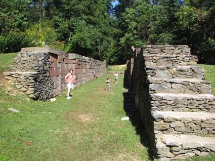
We generally enjoy an excursion up the Patowmack Canal Trail starting at its lower terminus where the blasting took place, and hike back uphill towards the Visitors Center. This path provides close-up views of the abandoned locks including the one shown in the photograph, above. Small barges floated into the slot where the people are standing in this picture, and would then be raised or lowered to circumvent the falls. It sure beat an overland portage!
Matildaville
A small town, Matildaville, rose around the holding basin where barges waited in turn before heading downstream through the locks. Matildaville existed solely as an artifact of the canal. It housed engineers, masons, laborers and their families during construction with its founding in 1790. After the canal opened in 1802 it provided a focus for maintenance, operations and toll collection. Bargemen traveling the length of the river on keelboats or rafts could stop here after poling along river for several days. By then many of them were ready for a hot meal and a rest.
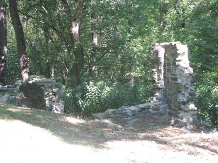
Henry “Lighthorse Harry” Lee, another Revolutionary War hero and father of Robert E. Lee, founded the town. He named it after his recently deceased wife, Matilda Ludwell Lee. George Washington stopped in Matildaville frequently as he traveled upriver from Mount Vernon to check on construction. The masonry shown here are remnants of the Superintendent’s House, the focal point and headquarters of the fledgling community.
Decline
Matildaville was a site of great promise with support from leading national and state political figures. It could have become a renowned town with a name resonating with people today. Yet, it crumbles into a hillside with only a few mortared stones to mark its existence. What happened? While the Patowmack Company succeeded in completing one of the most ambitious engineering marvels of the nascent United States, it failed to establish a lasting, profitable enterprise. Difficult construction challenges triggered seventeen years worth of debt before the first barge ever paid a toll. Variations in Potomac River depth, high and low, limited its usage. Tolls never covered the massive debts incurred to build and maintain the canal.
The Patowmack Company went bankrupt and its assets transferred to the upstart Chesapeake and Ohio Canal on the Maryland side of the river (which would have its own troubles when the railroad arrived). The Patowmack Canal became a meaningless relic practically overnight and it took Matildaville down with it. Most residents abandoned the town by 1830 but some people remained in the general area. Dickeys Inn was built from one of the old homesteads and lasted well into the early part of 20th Century, catering to Washingtonians who visited the falls as a tourist attraction. Now it is completely surrounded by parkland.
The Patowmack Canal Trail continues past the ruins of the old Matildaville ghost town and along the canal holding basin. It levels out for a leisurely stroll, protected from summertime sun by a leafy tree canopy, back to the Visitors Center. Walkers undoubtedly enjoy the woods but most of them probably never realize the historical significance of the canal or the engineering marvel it represents.
Readers who have an interest in waterfalls might also want to check my Waterfalls Index page.
Leave a Reply