
I was wandering through some old haunts recently. Then I spotted a building I used to see quite often. I’d forgotten all about this place, but was happy to find an unusual friend once again.
An Architectural Landmark
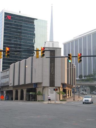
Observe the Arlington Temple United Methodist Church. This unusual structure sits in the Rosslyn section of Arlington County, Virginia, just across the river from the District of Columbia. It’s a well-known local landmark solely because of the gas station located beneath the sanctuary. Indeed, visitors fill up their tanks at the Chevron station at street level and save their souls at the Methodist Church up above.
It goes by various names locally. Back when I used to see it regularly it was an Exxon station. Then people called it the Exxon United Methodist, St. Exxon, Our Lady of Exxon, or somewhat generically Our Lady of the Gas Pump. I suppose they’ve probably recycled those old nicknames with “Chevron” by now.
It used to be quite entertaining to watch people turn the corner and behold this architectural magnificence for the first time. I often included it as a regular stop on my local tour for out-of-town guests just to get their reaction. We had to walk right past it to get to the nearby Metro subway station so it wasn’t even out of the way.
Convenient Access
You might wonder how worshipers get into the church. They don’t have to climb around gas pumps or through the garage, getting grease and oil on their Sunday best. No, a cement stairwell provides access from the sidewalk. Visitors can also use the Rosslyn Skywalk, a network of pedestrian overpasses connecting local buildings above street level.
That’s not readily apparent from my photo but you can get a better understanding of the layout from the video that someone else posted on YouTube that I’ve embedded above. It includes both the Skywalk and the church.
Momentary Whining
Since there’s still no Street view image of the Washington, DC area, the best I could provide was this satellite image(1). The church steeple is clearly visible. Also notice the odd triangular shape of the structure. They built it into a tiny wedge formed by two streets joining at an angle, amid a ring of offices, hotels and apartment buildings. The church almost disappears within the much taller structures surrounding it.
UPDATE: Street View finally arrived in the Washington, DC area two months after I wrote this article. The church now appears.
Purpose
This arrangement figures into the history of the Church. Take a look at the United Methodist News Services article, “Church atop gas station pumps people up in more ways than one,” and the accompanying video.
The founders wanted to establish an urban ministry. A local lumber company donated the land. When they built the structure in 1971 it had to fit within the confines of what was available, a small, irregular plot in the middle of a busy commercial district. To their credit, they understood the value of their location and used it to create a steady income by renting out the bottom floor to a gas station. This creative idea allowed the church to minister to the surrounding community without financial worries.
12MC Loves Footnotes!
(1) I’m super annoyed. Billings, Montana; Springfield, Missouri; and Abilene, Texas all have coverage on Google Street View, but not Washington, DC? Nothing against those fine towns, but no coverage of the CAPITAL of the UNITED STATES?!? Geez! How can that even happen?
Leave a Reply