
The third day brought us to our primary purpose, the start of the race series. So even though we’d already done a lot on the trip so far we still had a bunch of unfinished business ahead of us.
We also had another purpose, or at least I did. The “we” part of this equation didn’t really care. Day 3 would involve a degree of intense county counting too. I wanted to cross as many borders as I could without leaving behind any unsightly doughnut holes. That’s why the route deviated from the optimal path, with brief zigs and zags plus some out-and-backs for good measure. We did see some interesting sites although precision orienteering between precise waypoints defined the day.
Bonus Time in Eufaula
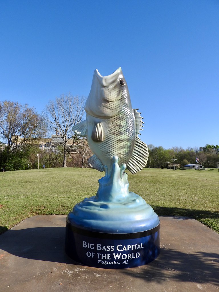
I guess I never contemplated the existence of a “Big Bass Capital of the World”. Then I learned that I was standing in it that morning, at least according to the residents of Eufaula, Alabama. I had plenty of time to contemplate that too. My wife ran a half-marathon each day (13.1 miles) while I focused on a much-shorter 10 kilometre (6.2 miles) distance. So that gave me a little time to poke around downtown Eufaula with my camera while I waited for her to finish.
It took a little while to run, clean up, pack our bags and grab something to eat every day we raced. Everything fell into a familiar pattern: race in the morning and drive in the afternoon. We ended each day in a town where we’d race the next morning. Three states, three days, three races. Boom-boom-boom. Just like that.
Providence Canyon
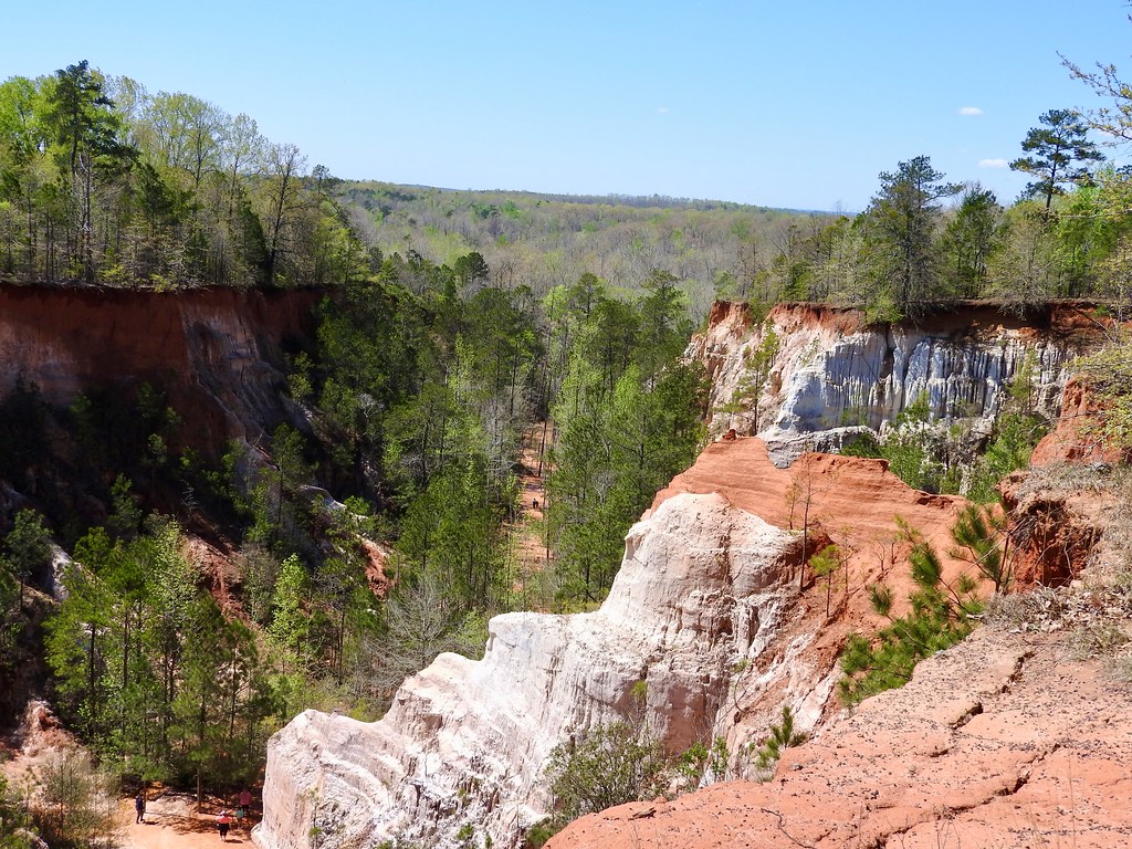
While we didn’t have time for a ton of attractions unlike the previous day, we did stop occasionally. Right off the top, I wanted to see Providence Canyon State Park (map). Some people call this Georgia’s “Little Grand Canyon” although I think it might be a bit of an overstatement. Nonetheless it’s fascinating in its own right.
A trail hugged the rim and the photo above provides a representative view. A different trail descended to the floor below and spurs allowed visitors to hike into the individual finger-like canyons.
It was a strange sandy surface. A thin layer of water drained along the canyon floor in channels down the trails. It wasn’t muddy in a traditional sense, it was more like walking along a beach just as a wave recedes. It was enough to wet the soles of our shoes but not enough to soak our socks. Later I learned that this happens because the surrounding water table often drains onto the canyon floor.
Folklore says that Providence Canyon exists because of poor farming practices and soil management in the 19th Century. That is at least partially true. Sandy soil here erodes quickly and easily. However historical records mentioned the existence of a canyon-like feature here even before farmers arrived. The additional erosion caused by farming made it more visually “spectacular” although it represented something of an ecological failure too.
Disputed Border At Long Last!
Driving and county-counting dominated the remainder of the day until we arrived at Macon, Georgia. I had one more county line to cross, a really important one to Twelve Mile Circle. It truly represented the unfinished business of this entire journey.
Longtime readers may recall my fixation with the protracted border dispute between Bibb County (now Macon-Bibb County) and Monroe County. It appeared in several articles and numerous tweets. For instance:
- 2009: Bibb-Monroe Border War in Georgia
- 2010: Bibb-Monroe Revisited
- 2011: Bibb-Monroe Border War Resolved. Maybe.
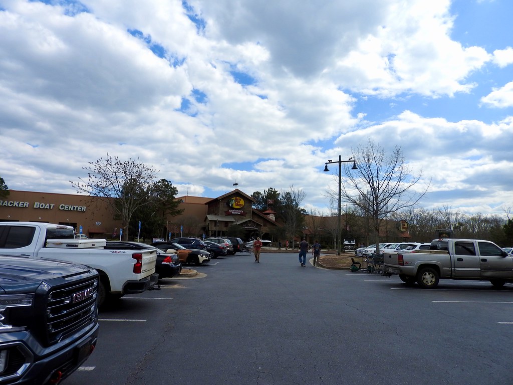
In spite of that optimistic 2011 article, the two parties still have not resolved their dispute as of 2022. It wasn’t just academic; the spoils involved a significant amount of tax revenue from a local Bass Pro Shops® that could fall on one side of the border or the other (map).
So this parking lot photo isn’t just some random parking lot. This is the actual Bass Pro Shops® at the center of the dispute! I’d have to give up my 12MC credentials if I didn’t stop here. Plus I captured Monroe County as an added bonus.
Ocmulgee Mounds

See! More mounds built by Paleo-Indians! I sheepishly informed my wife that I planned to stop at Ocmulgee Mounds National Historical Park even after our conversation during a similar stop just a day earlier. The location couldn’t have been more different though; decidedly within an urban area. The park sat practically in downtown Macon, Georgia (map); maybe just a mile away.
The Macon Plateau occupies a spot where the Atlantic coastal plain joins the Piedmont along the fall line. That was a might fine place to grow a city, and many well-known urban areas of the eastern United States (including Washington, DC) did the same.
It also made sense to pre-Columbian inhabitants, the native American people of the Mississippian Culture. They built a series of mounds here circa 900 to 1100. The Muscogee tribe occupied the area when settlers of European descent arrived centuries later. Native inhabitants considered this a sacred ground, and indeed people have lived here for several millennia.
After the U.S. government forcibly relocated the Muscogee tribe to Oklahoma, the former inhabitants of central Georgia still remembered their roots. They built a new capital for the Muscogee nation they called Okmulgee, and the town still bears that name today (map).
Friday Night in Macon

We settled into our hotel after a long day of racing, touring and driving. Then it was time to venture into Macon. After all, it was Friday night.
So I concentrated on building my brewery numbers. Theoretically, I could hit four of them by walking less than a third of a mile (map). Could we accomplish that and still be able to race the next morning? Well yes, of course we could. We took our time, sampled selectively and avoided overindulgence.
We visited all four: Piedmont Brewery, Macon Beer Company, Ocmulgee Brewpub, and Fall Line Brewing. Notice how they all fit within the theme of the afternoon. We were at the fall line where the Piedmont began in Macon, by the Ocmulgee mounds. I love it when my interests collide.
Eufaula Race Recap
I’m going to deviate from chronological order and talk about the morning’s race here at the bottom. I’ll do the same thing on the next two articles too. That way you can skip it if you like. I’m including it more so I have a record of it for myself.
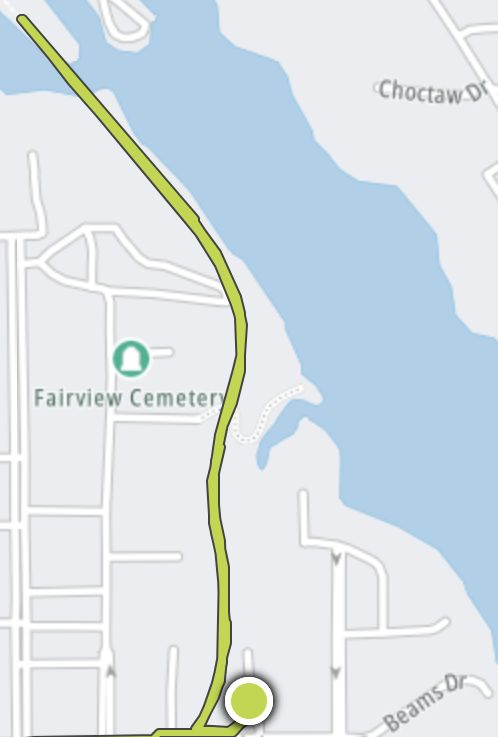
The course unfolded along the banks of the Chattahoochee River in Eufaula, at Yoholo Micco park. I wasn’t sure how I should pace myself because I wasn’t just running a 10K, I was running three 10K’s in three days. So I thought I should keep it right around the pace I’d normally reserve for a standalone half-marathon; a tad below 8:00 miles. That’s exactly what I did; a time of 49:11 at a 7:56 pace.
My watch said I did a lot better than that. Unfortunately that’s because I forgot to turn it off when I drove back to the hotel. An automobile sure helps the results though! I had to crop that out of the image but you can still see the residual tail just to the left of the starting point.
Articles in the Southern Hills Series
See Also: The Complete Photo Album on Flickr.
Leave a Reply