
I did my best to stay active during our Rocky Mountains trip as I explained in the previous installment. The entire trip revolved around the outdoors. That became something of a gamble during a transitional period between seasons. Snow still covered higher elevations. Meanwhile, prevailing wind patterns threatened us with afternoon rainstorms more characteristic of summer. Some hikes went better than others. Overall the weather seemed to cooperate with one notable exception.
Turtle Rock Loop

Our counterclockwise route landed first in Laramie, Wyoming, specifically to a spot a few miles east of town. There we planned to hike the Turtle Rock Loop at Vedauwoo Recreation Area, a property of the U.S. Forest Service.
Vedauwoo offered a variety of granite outcrops and easy access from Interstate 80, with Turtle Rock being one of its largest and most visible features. We intended to use the Turtle Rock Trail as a nice warm-up for hikes to come later. This would help us acclimate to our first day at higher altitude (~7,200 feet / 2,200 metres) without being too taxing. This relatively easy trail snaked around the perimeter of Turtle Rock for about 3.1 miles (5 kilometres).
It didn’t happen because…

The sky seemed to darken as we pulled up to the trailhead (map). I checked the weather radar on my phone and it seemed a small shower would pass to the west but might clip us in the meantime. I took my one and only photograph of Turtle Rock and we decided to wait in the car until it dissipated.
Instead, it got darker and more ominous as the rain started and suddenly exploded in intensity. Little pellets of hail became nickel-sized, then golf ball sized, and then we knew we had to get out of there. We managed to position the car under a tree with the hope of saving the windshield as hail the size of fists started pummeling us. Pine needles covered the hood of the car as hail broke through branches. It sounded like someone decided to take revenge on the car with a baseball bat, and damage reflected that.
Branches did protect the majority of the windshield although it cracked in one corner. Anything that stuck out got damaged; a side view mirror, a tail light, a reflector on the tailgate. Large dents pocketed the car from head-to-toe. Still, we felt lucky. Returning to the Interstate we noticed cars that couldn’t find protection experienced blown-out rear windows and damage like that. A panel truck even slid on the ice and landed upside down in the median.
Fish Creek Falls Trail
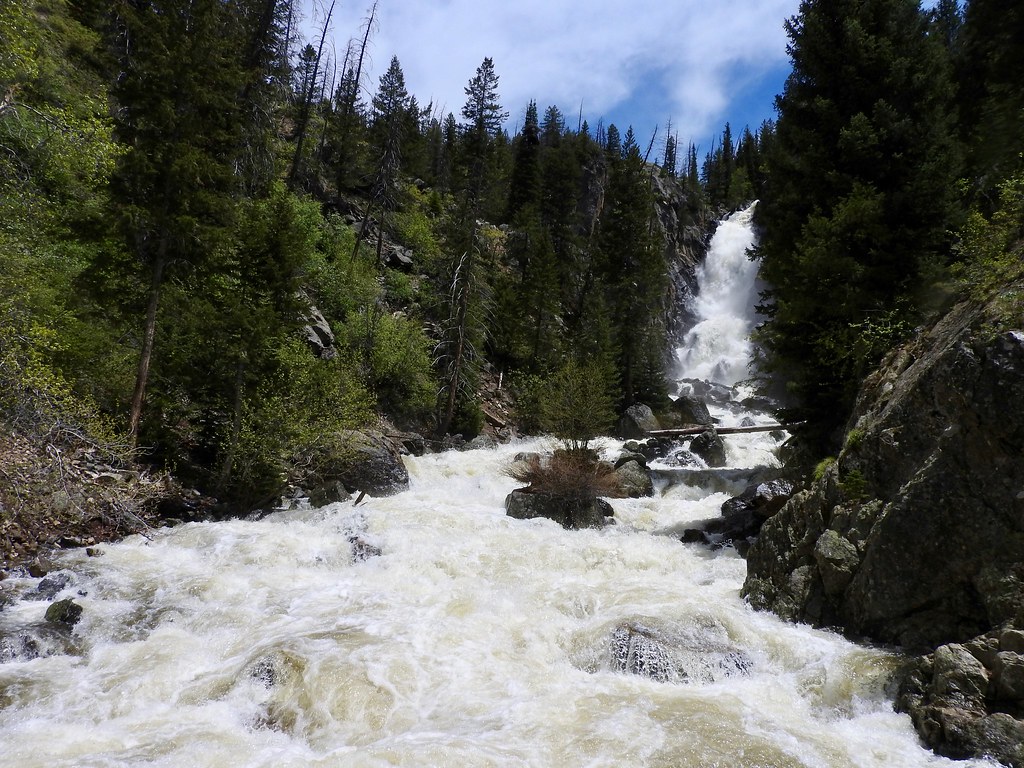
We drove down to Steamboat Springs, Colorado the next morning covered in cracks and dents, and swapped rental cars at their tiny airport. Thank goodness for insurance. The rental car company and our insurance holder will duke it out now and I’m sure we’ll write a check somewhere at the end of it. However, we didn’t let that ruin our trip as we pressed onward to our next hike at nearby Fish Creek Falls.
Memorial Day brought crowds although we found parking without too much trouble and very few people ventured beyond the short paved trail to the bottom of the falls (map). Snowmelt swelled Fish Creek into a torrent as it crashed through the canyon on its way to the Yampa River and onward into Steamboat Springs. We left the hordes behind, taking a steep rocky, sometimes muddy trail through conifer groves and aspen forest to the upper falls. There we turned around and came back. I still wasn’t completely acclimated during the upward climb and I felt a bit lightheaded. Even so, we enjoyed this hike and it made up for some of the pain from the previous day.
Cathedral Lake Trail

Then we ventured over to Aspen, Colorado where we explored the Cathedral Lake Trail (map). This led to a pristine alpine lake at an elevation well above 10,000 feet (3,000 m). More precisely, it would have led to a lake if we’d completed it. We managed to get a good distance into the hike. The exceedingly rugged terrain and altitude tired us more than we expected so we decided we’d done enough.
Later we saw a trip report from around the same time period that implied we’d made a good choice. Snow blanketed the trail just beyond where we turned around and ice completely covered the lake. We didn’t have the necessary equipment to hike through those conditions.
Baker’s Tank Trail / Boreas Pass Road

The final hike took place near Breckenridge, Colorado on the Baker’s Tank Trail (map). We paid attention to trip reports that recommended walking uphill on the trail to the tank and then downhill on Boreas Pass Road. This brought us through a gentle forested incline, to a final elevation of about 11,000 feet (3,350 metres) to which we’d become accustomed to by this time. Hiking back downhill on Boreas Pass Road offered amazing views of Breckenridge far down in the valley below.
The turnaround point — the actual Baker’s Tank of the trail’s name — once served the Denver, South Park and Pacific narrow gauge railroad circa 1884-1937. Steam locomotives required lots of water and they needed to stop periodically to refill. Baker’s Tank, sitting at mile 102.16 along the line according to signage, fulfilled that basic purpose. Now it sat at a scenic vista, an historic landmark and a convenient marker for hikers.
Articles in the Rockies Loop Series:
See Also: The Complete Photo Album on Flickr
Leave a Reply