
Residents of Denver often call it the “Mile High City” because its downtown closely straddles the 5,280 foot (1,609 metre) barrier. The local baseball stadium even features a row of purple seats on its upper deck to mark the memorable elevation. While impressive to a flatland Easterner like me, it hardly compared to some of the other places I reached in Colorado. I doubled that elevation during our adventure and pushed upwards even farther.
Running

I hadn’t planned to increase our elevation gradually as the week progressed although our selected route did just that. It seemed like a good idea in retrospect even if it happened by coincidence. On the second day we’d bumped our altitude from a mile high to about 6,900 ft. (2,100 m.) as we arrived in Steamboat Springs. I began to feel acclimated at that point, no longer woozy and lightheaded from oxygen deprivation. My body seemed to have adjusted.
Somehow I thought it might be a good idea to go on a morning run along the Yampa River (map). Steamboat Springs offered a beautiful paved trail, mostly flat, along its riverbank where it flowed through the long, skinny town. It beckoned just a block away from our hotel. I brought running clothes for just such an occasion and even remembered to adjust for the temperature difference. Although early June, these mountain towns barely rose above freezing at dawn, the time I preferred to run. I dressed warmly and it wouldn’t be a problem.
I began my run, made it a couple tenths of a mile and… started sucking wind. Obviously I hadn’t acclimated as much as I’d thought. My legs seemed fine although I couldn’t get enough oxygen pumping to move them at anywhere near my normal pace. I throttled way back until I found a comfortable speed, a full minute and a half per mile slower than my normal pace. Nonetheless I pounded the pavement for a little more than six miles (10 km) and finished exhausted.
Independence Pass

Independence pass (map) allowed automotive traffic on Colorado state highway 82 to cross the Sawatch Range and the Continental Divide. This covered the shortest direct distance between Aspen and our next stop in Leadville. However, the road also closed during the winter and didn’t reopen usually until the Friday before Memorial Day. Sometimes it opened later and I sweated out those details as our trip approached. We caught a nice break and it opened on time this year so we drove across the pass about five days after its seasonal availability.
Here the elevation reached 12,095 ft. (3,687 m.). I felt almost tipsy at that altitude, while remaining completely sober of course. The simple act of walking across the parking lot to the viewing platform left me winded and slightly disoriented. And it was cold. It felt like winter again although the views more than made up for the inconvenience.
I noted a couple of tangential items while there too. The previous day, at Aspen Brewing Company, I purchased a shirt with their “Independence Pass Ale” label design printed on the back. Those initials spelled out IPA so beer aficionados should be able to guess the style. Anyway, the artwork featured a reproduction of the sign found at the top of the pass so naturally I had to remove my jacket and pose next to the real sign wearing my new shirt. Then I got the jacket back on right away because it was freezing up there.
The second interesting item related to some graffiti I found on the door of the restroom at the summit. I don’t know who decided to recreate a topographic map of the pass although I liked the way they thought. Normally I wouldn’t condone vandalism although this one seemed benign.
Pikes Peak
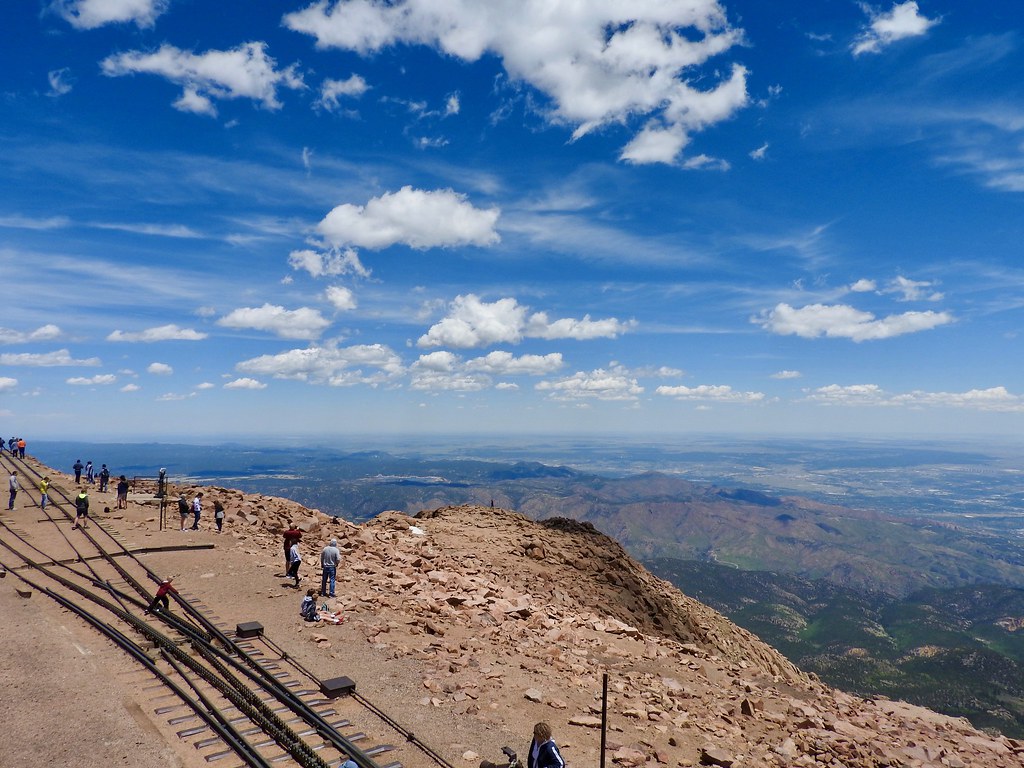
Then we turned it up a notch. Pikes Peak (map) seemed like it would be a little too touristy for my tastes although I’d never been there before so I needed to see it. I shouldn’t shun something just because everyone else had the same thought. There were reasons why people have flocked to the summit for more than a century.
Originally I wanted to take the cog railway. Unfortunately it shut down just prior to the 2018 season with uncertain prospects for ever reopening due to expensive maintenance issues. The only remaining option involved a long, scary uphill drive. You certainly didn’t expect me to hike up to the top?
What a glorious day it turned out to be at 14,115 ft. (4,300 m.). The temperature hovered at a practically balmy 55° Fahrenheit (13° Celsius) with no wind. Clouds remained minimal and we could see in every direction all the way to the farthest horizon. It felt more like looking out from an airplane window than from a fixed terrestrial position. That feature distinguished Pikes Peak from other remarkable mountain views we’d experienced earlier. The summit didn’t have any other summits nearby to mask its scale. It stood out isolated from the surrounding terrain.
Garden of the Gods

We finally climbed down from the sky and landed at the relative lowlands of Colorado Springs at “only” 6,000 ft. (1,800 m.). While not that elevated compared to the Rocky Mountain summits we’d just seen, it sufficed as a training ground for U.S. Olympic athletes. This offered a competitive edge in sporting events held at places closer to sea level, the opposite effect of my run at Steamboat Springs.
We didn’t have enough time to visit the training center although we did make a stop at Garden of the Gods. A local landowner gave the city of Colorado Springs title to this land in the early 20th Century. He stipulated that it must become a free public park open to all. The city took that to heart and offered a number of easily accessible paved paths through these ancient sedimentary stones (map).
Articles in the Rockies Loop Series
See Also: The Complete Photo Album on Flickr
Leave a Reply