
I took something of a stealth trip. Normally I’d announce my upcoming adventure to the Twelve Mile Circle crowd well in advance and ask for suggestions. This time I just went out on my own. I knew what I wanted to do. In fact, only subscribers of the 12MC Twitter learned about it, watching the path unfold in real time. My wife found an opportunity to run a race in Boulder, Colorado so I tagged along. We wandered through the Rocky Mountains of northern Colorado for most of a week and into Wyoming briefly before spending a couple of days with friends outside of Denver.
Mud Season
The path took us on a counterclockwise journey beginning and ending at Denver International Airport. Each day brought a different town: Denver to Laramie to Steamboat Springs to Aspen to Breckenridge to Colorado Springs and back to Denver. This particular time of year fell between seasons. Skiing ended a few weeks beforehand. Summertime activities beckoned just over the horizon. Locals called this shoulder period Mud Season, sometimes affectionately, sometimes derisively. Permanent residents used these weeks to catch their collective breath and prepared for returning tourists that would arrive when conditions improved.
Little mud remained by the time we set out on Memorial Day. We did encounter some sloppy conditions and even a bit of snow melting at higher elevations. However, overall, most places seemed basically dry while the temperature remained comfortably crisp especially in the mornings.
What does someone do in an area known for skiing when snow doesn’t blanket the earth? Hike. We hiked a lot. Our typical morning started with a drive towards the next town. We’d eat a hearty lunch, often at a brewery or brewpub. Then we’d hike most of the afternoon. Some might suggest flipping the schedule to minimize the possibility of afternoon rain. Even so it seemed to work for us so we kept with it. Throw in a few sites and attractions along the way and repeat. Usually I gain weight on vacation. Not this time. We stayed active.
Observant readers may have already noticed the contradiction suggested by our path. We circled through and around the Rockies, yet never entered spectacular Rocky Mountain National Park. The trip actually served a different purpose. I’ve been to the park before, even driven the jaw-dropping Trail Ridge Road, so I felt no need to cover old ground when so many new experiences awaited.
When in Doubt, Think of the Counties
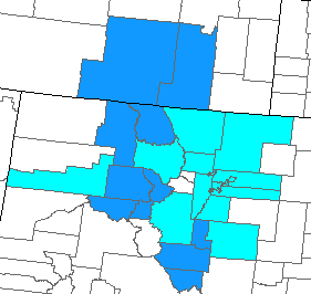
This excursion became another county counting excuse. My northern Colorado map contained a few holes and my Wyoming map could always use some additional focus. The image above showed all of the counties we entered during this particular trip. Light blue represented counties visited previously. Dark blue represented new captures. Don’t worry about the doughnut hole in the middle. I’ve already visited those two counties before although not on this particular trip.
The 11 new county captures included:
- Colorado: Custer; Eagle; Fremont; Jackson; Lake; Pitkin; Routt; Summit; Teller
- Wyoming: Albany; Carbon
Most of them came quite naturally as suggested by the path of the circle. I also gained a few new overnight counties, a higher-level distinction on my list than those I’ve simply touched. We slept somewhere different each night and that let me run up the score a bit on that category. As the trip ended my lifetime total hit 1,447 counties (46.1% of all counties in the United States). My overnight list approached 250. I think it will be a really nice achievement when I finally get to 365 overnight counties. That will take awhile.
Deviations from the Optimal Path
I did take one short out-and-back jaunt to capture Carbon County, Wyoming. It filled a nice big chunk of geography and had a disproportional impact on my map. That pleased me. When I’ve compared my map to others with very similar totals I’ve noticed that mine seems to have a lot less color because most of my travels involve very small counties in the eastern states. I needed some more large western counties to fill the gap.
Just before we left for the trip I also noticed that I could pick up Custer and Fremont Counties in Colorado without a lot of additional effort. I rearranged some of our sightseeing and extended the loop farther south. This added a couple of driving hours although my wife rolled with it. She’s used to dealing with my county counting fixation.
We did much more than simply counting counties though. I’ll describe those adventures in future articles.
Articles in the Rockies Loop Series:
See Also: The Complete Photo Album on Flickr
Leave a Reply