
There are 30 boroughs and census areas in Alaska – “The Last Frontier“
Also be sure to see my United States County Counting Page for the rest of the states.
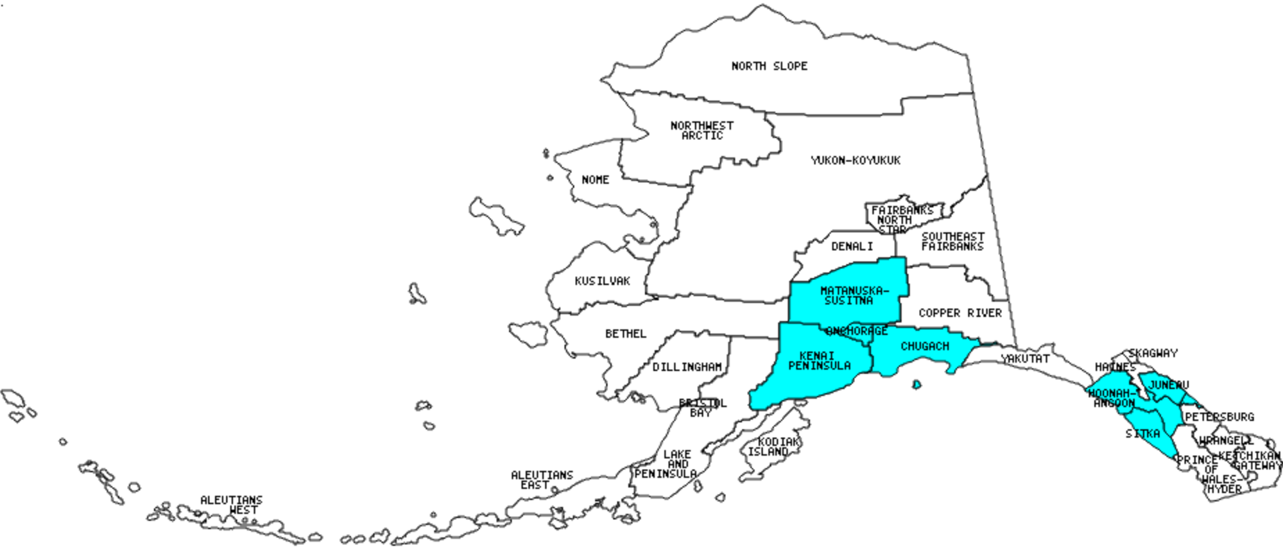
I have visited 11 boroughs or census areas = 36.7% of those in Alaska
Counties visited are colored-in; counties still needing to be visited are blank. Map created using Mob Rule.
Twelve Mile Circle Articles Featuring Places in Alaska
Markers designate the Alaska locations featured in Twelve Mile Circle articles.
Interesting Alaska Borough Trivia
- Alaska is one of only two states that does not have named counties. Alaska has boroughs (and Louisiana has Parishes).
- It also has one very large Unorganized Borough administered directly by the state that is broken into several Census Areas. The Unorganized Borough, when combined, encompasses the largest “county-equivalent” jurisdiction in the United States at 330,074 square miles.
- Juneau City & Borough has no outside road access even though the City of Juneau is part of mainland North America. For more information and an explanation see my Juneau page.
Boroughs and Census Areas in Alaska

Below are the 30 boroughs and census areas in Alaska. Although infrequent, boroughs and census areas sometimes do change so please let me know if any of this information is out of date and I will update it. Those boroughs and census areas that I have visited are highlighted in Red. Readers can also link to any articles manually in this section if the map isn’t working.
- Aleutians East: Aleutians East / Aleutians West Border; Manly Places
- Aleutians West Census Area: Amatignak Island; Aleutians West / Aleutians East Border; Menacing Island; Samalga Island
- Anchorage (Municipality of): Largest borough population in Alaska (260,283 people in 2000 Census); Other State Nickname Thingies; Flattop Mountain Summit; Four Runways – Four Miles; Glacier Brewhouse; Midnight Sun Brewing Co.; Midnight Sun in Anchorage; Snow Goose Restaurant & Sleeping Lady Brewing Company
- Bethel Census Area: More Land than People
- Bristol Bay: Smallest borough in Alaska (505 square miles): King Salmon
- Chugach Census Area: Million Dollar Bridge; Anton Anderson Tunnel (aka Whittier Tunnel)
- Copper River Census Area: Out of Season
- Denali: Anderson Rest Area; Separate but Tallest
- Dillingham Census Area: Portage Creek
- Fairbanks North Star: Birch Lake; Chena Hot Springs; Chena Riverwalk; Constitution Hall; East Ramp Airport; Fairbanks Mileage Pole; Fairbanks North Star / Southeast Fairbanks Border; Fountainhead Antique Auto Museum; Golden Heart Plaza; HooDoo Half Marathon; Knotty Shop; Large Animal Research Station; Moose Antler Arch; Museum of the North; North Pole; Santa Claus House; Tanana River; Trans-Alaska Pipeline; Twelve Mile Road House; Warp Drive; Wrong Way Lane
- Haines
- Hoonah-Angoon Census Area: Grand Pacific & Reid Glaciers; Margerie Glacier; Scenery; South Marble Island; Waterfalls and Terrain; Zip Rider
- Juneau: Downtown Juneau; Mendenhall Glacier and Environs; Mendenhall River Rafting; Not the Usual; “Out the Road”; Panoramic Views of the City of Juneau; Perseverance Trail; The Renowned Alaskan Brewery; State Capitals Meet Time Zones; Various Points Around Juneau; Worst State Capital Location
- Kenai Peninsula: Recent NIMBY; A Prisoner to Geo-Oddities; Barwell Island, Captain Cook State Recreation Area, Exit Glacier, Harding Icefield, Homer Brewing Company, Homer Spit, Kassik’s Kenai Brew Stop, Kenai Fjords National Park, Kenai River Brewing Co., My Favorite Road Sign; Russian River Falls, Russian River Ferry, St. Elias Brewing Co.; Spit
- Ketchikan Gateway: Literal Roads to Nowhere; Ketchikan Airport; Gravina Island Ferry
- Kodiak Island
- Kusilvak Census Area: Full Names
- Lake and Peninsula: King Salmon
- Matanuska-Susitna: Birch Syrup Geography; Dear Wasilla; Nearly Willow; Denali Brewing Co.; Talkeetna
- Nome Census Area: Golden China; Midnight Mountain
- North Slope: Largest borough in Alaska and largest “county” in the United States (94,763 square miles — see note above about the Unorganized Borough though); A Town Named Deadhorse; Prudhoe Bay Oilfield; Beaufort Sea Barrier Islands; Dalton Highway; Going Postal; Trans-Alaska Pipeline.
- Northwest Arctic: Kotzebue
- Petersburg
- Prince of Wales-Hyder Census Area: Point A
- Sitka: Points of Interest; Sitka National Historical Park; Somewhere Between Juneau and Sitka
- Skagway
- Southeast Fairbanks Census Area: Big Delta State Historical Park; Delta Junction; Little Gold Creek; Southeast Fairbanks / Fairbanks North Star Border
- Wrangell
- Yakutat: Smallest borough population in Alaska (808 people in 2000 Census); National Preserves
- Yukon-Koyukuk Census Area: Arctic Circle; Coldfoot; Finger Mountain, Fort Yukon; Grayling Lake, Gobbler’s Knob, Happy New Year Creek; Koyukuk River; Nenana; Stevens Village, Yukon River Camp
Quick Facts About Alaska
- Location: North American Arctic/Sub-Arctic exclave of the United States. See map above.
- Size(1): 570,641 square miles. Alaska is by far the largest state in the United States. The next smaller state is Texas at less than half its size.
- Population(2): 737,438 people. Alaska is the 48th most populous state. The next more populous state is North Dakota and the next less populous state is Vermont.
- Population Density: 1.3 people per square mile. Every other state in the United States has a higher population density than Alaska. The next more densely populated state is Wyoming which has four times more people per square mile.
- Bordering States: Alaska does not shares a border with any other states. Its entire border is with Canada.
- Admission to the Union: January 3, 1959. Alaska was the 49th state admitted to the Union, after Arizona and before Hawaii.
- Capital: Juneau.
- Highest Point: 20,320 feet at Denali (Mount McKinley). See SummitPost’s Denali (Mount McKinley) page.
- Lowest Point: Sea Level at the Pacific Ocean.
- Government website: State of Alaska Home Page.
- Official Tourism website: TravelAlaska.com.
- Still not enough? See Wikipedia’s Alaska page.
Sources:
(1) Wikipedia: List of U.S. states and territories by area. Land area only.
(2) Wikipedia: List of states and territories of the United States by population. Estimated population on July 1, 2019.
Leave a Reply