
Chugach State Park, Anchorage, AK (July 2010)
We didn’t plan to climb Flattop Mountain (map) that beautiful July morning. We had completely different plans, actually. The waiter during breakfast said we should go. The desk clerk at the hotel told us the same thing. The day was too perfect, too perfect!, to waste it on anything other than Flattop. It’s an Anchorage tradition; the most advantageous ratio of hiking skill to panoramic views around.
They assured us it takes only a couple of hours for hikers that are even in moderate shape, and sure, we should be able to get to the top even with our four-year-old if he’d be willing to give it an honest shot. We ditched our well-researched plans for the day, went out into the unknown, and drove straight uphill towards nearby Chugach State Park. Score one for the insightful people who recommended this hike: it’s awesome.
Getting Ready
Flattop Mountain is completely accessible and only minutes from downtown Anchorage. We drove there on our own but I understand there’s also a Flattop Mountain Shuttle that will drop people off at the trailhead and pick them up later. I don’t know anything about it but I’ve seen good reviews on the Internet. It might be a possibility for people staying at hotels in the city who might otherwise have to pass up the opportunity.
Directions
Head south out of town down to O’Malley Road, then east — passing the Alaska Zoo — all the way to Hillsdale Drive. Turn right at Hillside, then left at Upper Huffman and follow the signs gaining elevation all the way to the Glen Alps trailhead (see directions on Google Maps). The state should get some credit for the signs. They’ve marked each turning point well. We’d never been there before and had absolutely no trouble finding it.
The parking lot is large, in fact surprisingly large. That’s a testament to the popularity of the hike. We were there on a weekday morning, albeit on a perfect sunny day, and the lot was already about two-thirds full.
Options
The trailhead offers some choices. Those who would rather stroll than hike can take a gentle loop trail directly next to the parking lot to an overlook above the Anchorage bowl. It’s a decent view that requires minimal effort, perhaps accessible even to those with moderate handicaps. There are other trails leading down into nearby valleys.
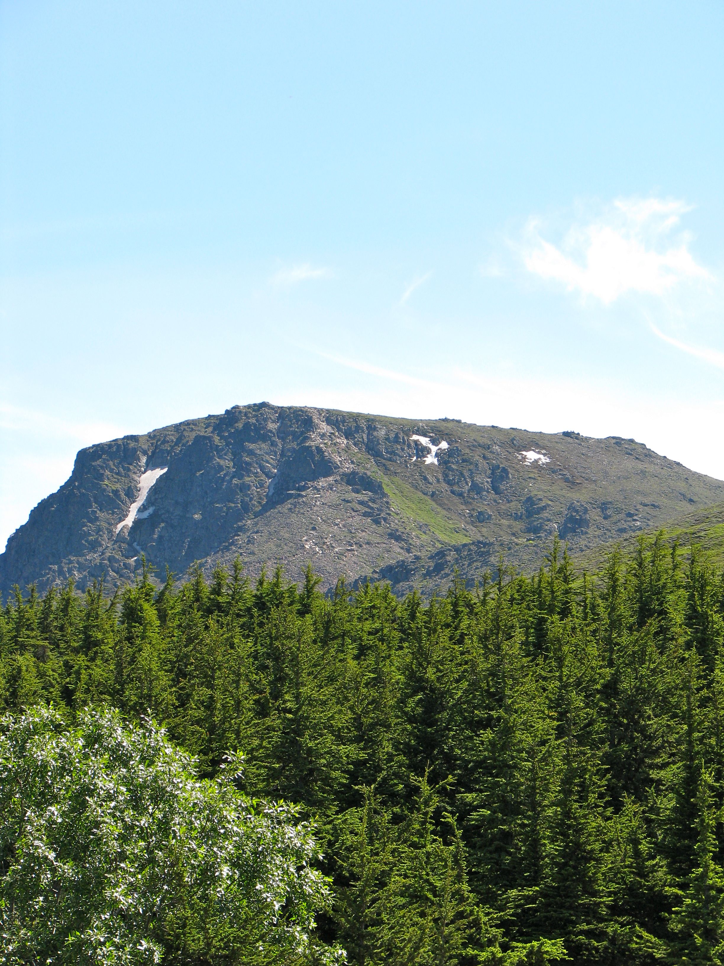
The star, however, is Flattop and we headed towards the wooden stairs leading towards the Blueberry Knoll Loop Trail and to the Flattop Peak Trail beyond. Flattop presents an unmistakable profile. It’s the mountain, as someone might expect, with the (relatively) flat top. It’s an anomaly backing up to several jagged peaks.
We used to hike frequently in our younger years but we haven’t done much lately. Nonetheless we hadn’t forgotten how to prepare. We brought backpacks loaded with plenty of water and nutritious snacks. We brought layers of clothing that could be worn or removed to suit a variety of weather (including rain gear which wasn’t an issue that day), and of course we made sure to visit the public toilets at the trailhead before heading up. There are too many people and too few trees along this trail to make the alternative a viable option.
The Hike
It’s not a terrible difficult hike really, but the the final stretch gets a bit dicey especially with kids in tow. The trail stretches from the parking lot to the summit in three stages:
- Blueberry Knoll forms the first stage, and hikers can round the knoll either clockwise (for a close-up view of Chugach valleys and mountains) or counter-clockwise (to gaze upon the Anchorage basin). Most people follow the counter-clockwise direction and we took that route on the way up, using the other route on the way down, and enjoying the alpine tundra all along the way. This was the only place where we could touch unmelted snow from the previous winter directly next to the trail, a rare treat for us “Southerners” on a July day.
- The middle stage works on getting hikers closer to Flattop. Much of the trail here has been converted into several extremely long stairways at the sharper elevation changes along the route.
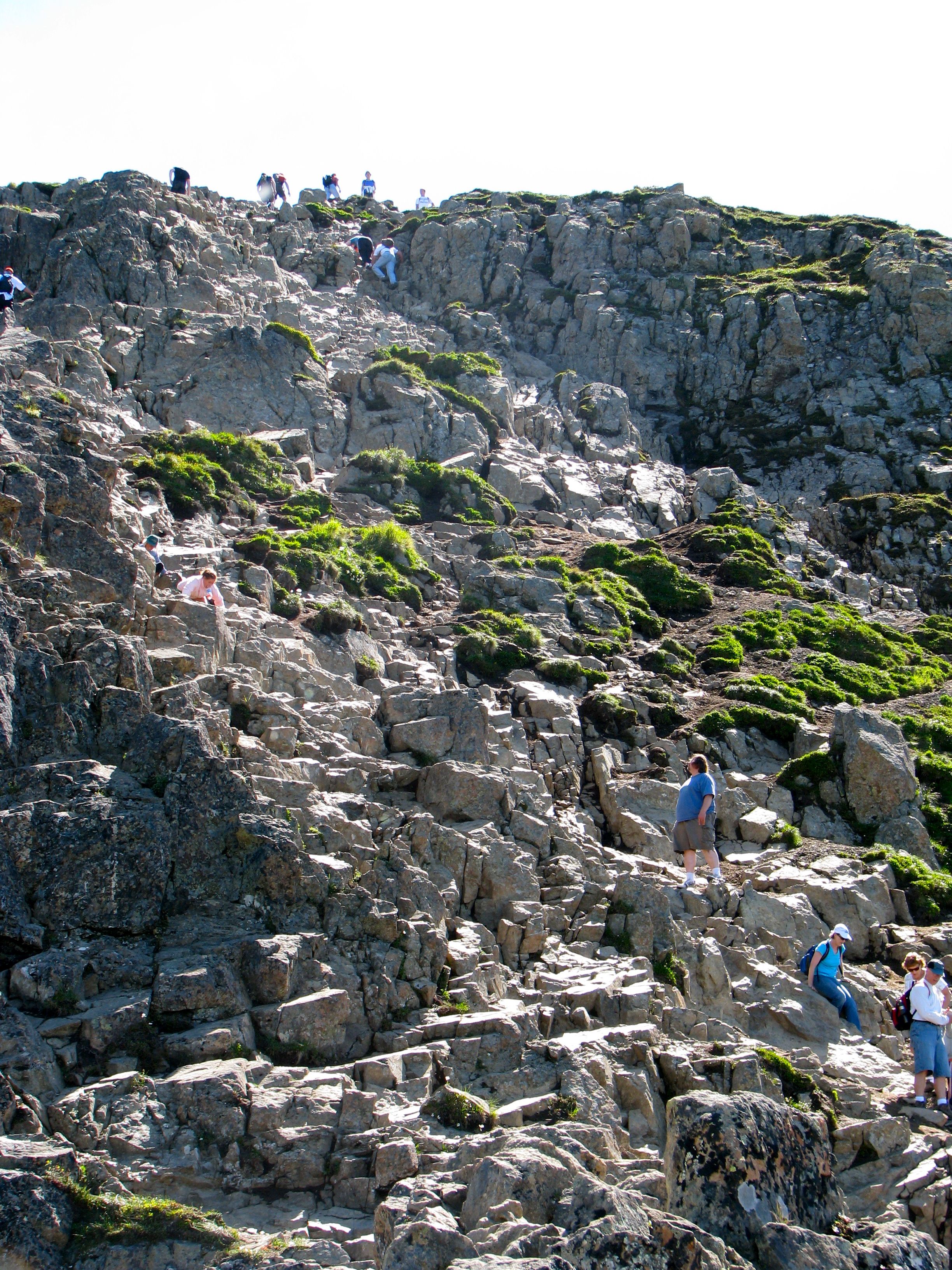
- The final leg, seen in the photograph above, traverses a steep incline with short, frequent switchbacks that eventually transforms into a hand-over-fist climb. This part of the trail is above the treeline. Blazes are considerably faded so it’s hard to find the preferred path. Not to worry, the summit is in sight and any number of tributaries will do the trick on this final ascent.
Overall Assessment
Personally I found the second stage the most difficult because it seemed like one tremendous and continuous, boring but strenuous staircase. Both the pace and the gait seemed dictated by the artificiality of the path. The final leg was a lot steeper but it allowed me to chose the placement of my feet, the size of my step, and the specifics of my path. The base of each switchback also gave me a brief opportunity to take a couple of steps on relatively flat terrain and give my calves a break. I didn’t mind shimmying up the rocks, either. That was just good fun.
It’s a total one-way distance of about 1.5 miles and a total vertical climb of 1,280 feet.
On the Summit
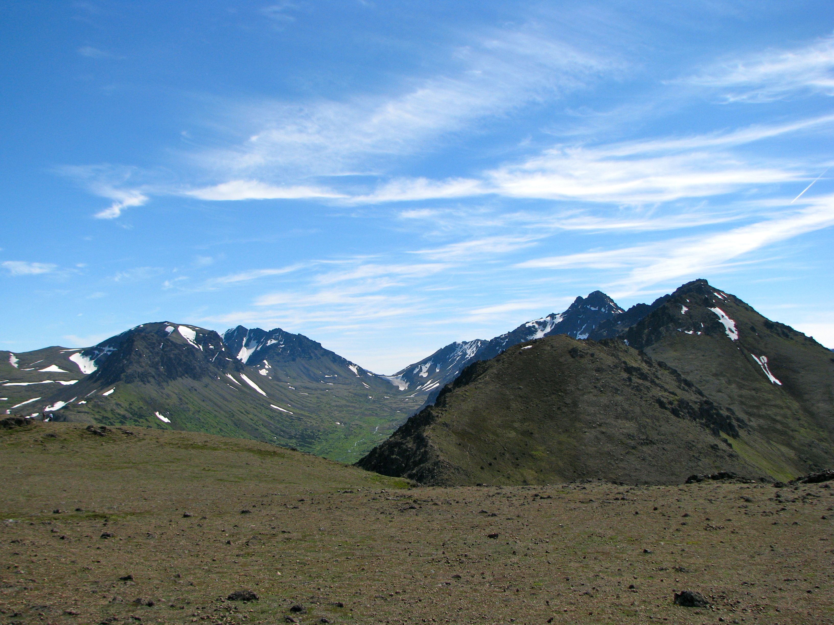
It’s an otherworldly existence atop the summit. While not absolutely pancake flat like it may appear from the faraway valley floor, it’s much flatter than anything else in the area. It would be flat enough for a homesite if someone ever figured out how to ferry supplies up to it. The barrenness is particularly striking. There was barely a puff of wind to let us know we were sitting exposed at 3,550 feet above sea level. It seems like the surface of another planet.
I’ve seen lots of write-ups about the crowds of people on Flattop. That’s probably the case in Alaskan terms but any easily accessible peak like this in the Lower 48 would draw hundreds of people to the summit on a picture-perfect postcard day like this. You can certainly see a few people in the one photo above and in the video I posted, but it didn’t seem all that crowded to me among the several acres atop Flattop Mountain. Perspective is everything, I suppose.
An Amazing View
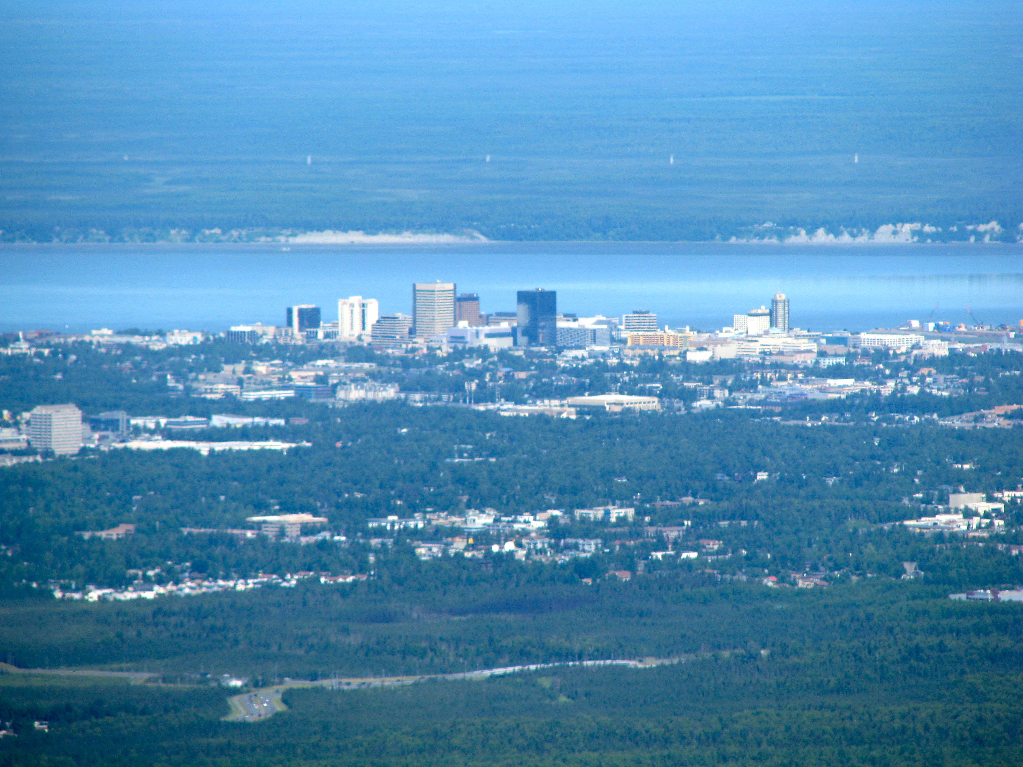
The views! They were simply stunning, out to the horizon as far as the eye could see. The towers of Downtown Anchorage (above) appeared in plain view. Denali/Mt. McKinley, the highest point in North America, peeked above the earth’s disk a hundred and fifty miles away. Ironically this was our only sighting of Denali. Ten days later we traveled up to Denali State Park and we couldn’t see a thing because of the clouds. We were told by several locals in Talkeetna that nobody had seen Denali in… the last ten days.
We could also see clearly over to the Kenai Peninsula, down to Cook Inlet and along the Turnagain Arm. Facing the other way we could look down into the Matanuska-Susitna Valley and spot the outline of the Alaska Range further in the distance, and of course we could see the entirety of the Anchorage Bowl in stunning clarity.
I can see why Flattop is an Anchorage institution. It’s a great little hike; not too long and not too difficult, and the views are awesome. Trailhead access is a breeze and it’s barely a stone’s throw from a major city. I’ll do it again in a heartbeat when I return to Anchorage.
Leave a Reply