Tennessee I-40 Time Zone Crossing

So you’re driving along Interstate 40 in eastern Tennessee and you want to know where the time changes. Let’s make this easy. It happens between Mile Markers 340 and 341.

I’ll guess that answers the question for about 99% of you. Feel free to put the phone down now and focus on driving. Thanks for stopping by and good luck on the rest of your trip!

However, if you want more details than anyone would ever care to know, please keep reading.


The Setup

It seems like everyone wants to know where the time zone changes on I-40 in Tennessee. I’ve received tons of search queries recently about that exact spot. Most of the web hits land on my phenomenally popular Interstate Highway Time Zone Crossings page. That’s completely expected of course because the answer definitely exists there. But it’s also a very comprehensive list and it’s a bit confusing for those looking for a single piece of information.

Many time zone changes in the United States happen at state borders. Thus, it’s easy to know when the time changes. It’s pretty apparent, for example, when someone crosses between Georgia and Alabama. However, Tennessee falls within an interesting geographic situation and it’s also really wide. So a drive from Memphis to Kingsport stretches nearly 500 miles and takes more than 7 hours. It makes no sense to keep the entire state within a single time zone.

Therefore the U.S. government had to find a way to split Tennessee. Logically they used a convenient basis that already existed: county structures. As a result, about a quarter of Tennessee’s counties fell into the Eastern Time Zone and three-quarters within Central Time.


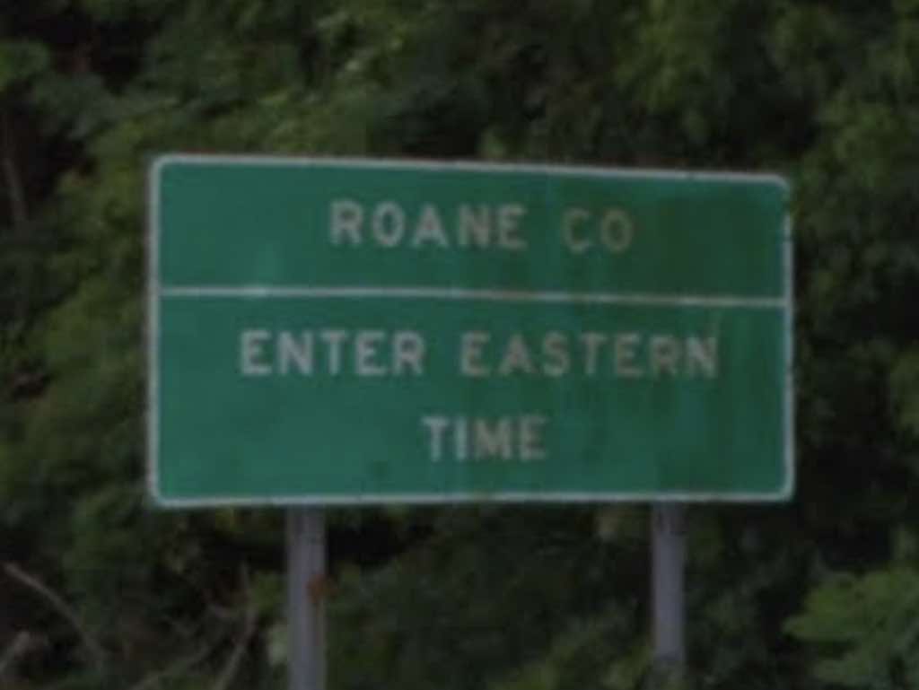
Westbound (going from Eastern to Central Time)

Entering Central Time Zone on I-40, Tennessee. Image from Google Street View; October 2021.

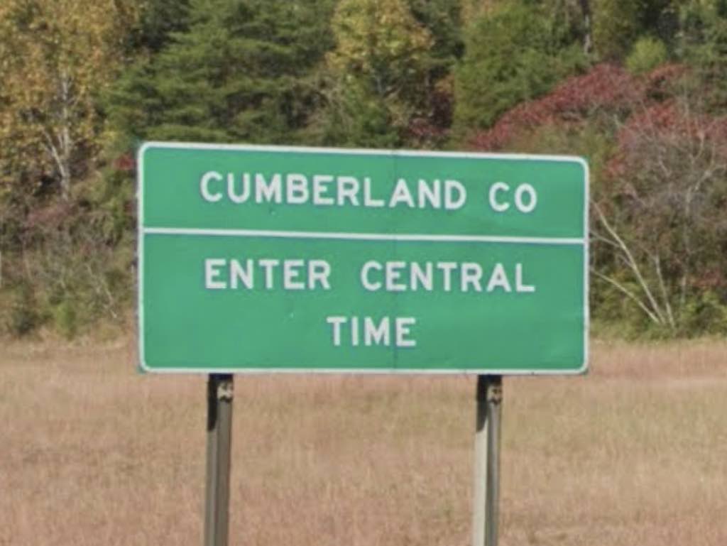
For those driving along Interstate 40, the time zone boundary falls between Cumberland and Roane Counties.

I’ve been to Tennessee plenty of times and visited many of its counties. However, I don’t know the boundaries well enough to understand intuitively where this happens. You probably don’t either. Otherwise nobody would ever need this page. Right?

The Cumberland – Roane border doesn’t run near any major cities either. Knoxville is probably the closest population center, about 45 miles to the east. So someone driving west out of Knoxville will hit Central Time about 45 minutes later, plus or minus. That’s a pretty good rule of thumb and something fairly easy to remember. For something more exact, use the mile markers or coordinates I posted above.


Eastbound (going from Central to Eastern Time)

Entering Eastern Time Zone on I-40, Tennessee. Image from Google Street View; June 2018.

That trick won’t work heading eastbound, from Central Time into Eastern Time. It’s something like 150 miles from Nashville. Although I guess someone could watch for road signs showing distance to Knoxville. Or again, use the information I posted above.

Of course, another option might be to watch the time flip on your mobile phone. Honestly, I’ve had mixed results with that alternative. Sometimes a phone grabs a cell tower right near the border and it happens quickly. Other times it’s delayed or even gets stuck on the “wrong” time. Naturally none of this will help you if you’re using an old-school watch. You’ll have to deal with that manually.

Comments

15 responses to “Tennessee I-40 Time Zone Crossing”

  1. Gary Avatar
    Gary

    My parents live just outside of Pigeon Forge, about 35 or 40 miles southeast of Knoxville in Eastern Time. But my father goes to Nashville frequently, and as known the time zone line is between Knoxville and Nashville. Nashville is roughly 200 miles or so from them, and an hour behind. Where I live here in Florida (near Orlando) is Eastern Time, but my cousin who lives near Pensacola is in Central Time. The time zone line is about 25 or 30 miles west of Tallahassee.

  2. Peter Avatar
    Peter

    Although I’ve done a good deal of travel in both the US and several foreign countries I’ve only crossed a time zone on land once. It was Georgia-Alabama.

  3. Tom Keifer Avatar
    Tom Keifer

    I live near Nashville and travel (on I40) to East TN often, therefore changing time zones. This separation of time zones generally follows the eastern edge of the Cumberland Plateau which provides a natural geographical separation between the two zones. There is a 500-1000ft escarpment between the plateau and the the valley below, thus separating somewhat the population and commerce.

    1. Ron C. Avatar
      Ron C.

      Are you Tom Keifer of Cinderella fame?
      I am in Tennessee and planning on day tripping to Nashville . Anything particular I should see in Nashville besides The Grand Ole Opry?

  4. Suzanne Ward Avatar
    Suzanne Ward

    West on interstate 40 out of Knoxville
    Tennessee the time changed at mile marker 328.2

    1. Twelve Mile Circle Avatar

      Do you mean that’s when the time changed on your cell phone? Because there’s often a delay until a phone picks up the next cell tower.

  5. Rebecca Candler Avatar
    Rebecca Candler

    I love all this info.Just curious for now,but want to travel i-40 to the end at Barstow.And go to the west coast to see San Diego and the Pacific Ocean.

  6. Rico Avatar
    Rico

    Lol exactly what I wanted to know and found your page through Google. MM 376 on 40 in TN on way to AZ. Thanks for the info.

  7. Amanda Avatar
    Amanda

    Does anyone local know the location of the change on 65N?

    1. Twelve Mile Circle Avatar

      You can probably find what you need on my more general Interstate Highway Time Zone Crossings page.

    2. Jo Avatar
      Jo

      There should not be a change on I-65 since it travels north & south and is well into the Middle TN area.

      1. Derek F. Avatar
        Derek F.

        Interstate 65 switches between Eastern and Central Time Zones at least twice traveling north from Nashville. Time changes to Eastern in Kentucky, then back to Central northwest of Indianapolis as the six counties at the far northwest corner of Indiana have socioeconomic ties to Chicago(the Southern Shore line of the Metra even serves communities in this region of Indiana such as Hammond, Gary, Michigan City, and LaPorte.)

  8. Daniel Avatar
    Daniel

    It’s in Kentucky somewhere between mile marker 50 and 59.

  9. lynne barton Avatar
    lynne barton

    what would be REALLY helpful is a Tennessee map showing both time zones and cities. For those of us not traveling on I 40.

  10. Elysia Duke Avatar
    Elysia Duke

    I wish that I can post the latest photo from Google Maps on here. It must be a very old photo of the Roane County sign before Airport Road was built. Today, the sign is on an overhead before the underpass before getting off of the Cumberland Plateau.

Leave a Reply

Your email address will not be published. Required fields are marked *

Latest Comments

  1. Technically it’s not always correct to say EST/CST, etc…. but just an indication that I’m changing time zone is enough,…

  2. In general, I wonder why navigating from the Atlantic Ocean to the Black Sea doesn’t count as inland navigation.

  3. Re: East/West Carroll parishes, you’re close, but the real reason for the split was more political than demographic or cultural.…