
The ultimate destination was Dayton, Ohio and it took about seven and a half hours to get there. However we didn’t just sit in Dayton for an entire week. If I had to drive all that way you better believe I would do some County Counting along the way too. At this point I’ve already hit every county near my home and new ones sit several hours away. So this was a good opportunity to beef up the numbers in spite of traveling to Dayton for other purposes.

In total I captured eleven new counties on two separate day trips from Dayton. That single first-time county separated from the rest is Perry County, Ohio. I got that one during a quick out-and-back from Interstate 70. It was a pretty simple exit towards the town of Thornport (map), turning around in the Dollar General parking lot across the border, and then returning to I-70. It added maybe five minutes to the drive.
In this article I’ll talk about five new captures falling somewhat North(-ish) of Dayton: Miami, Shelby, Logan, Union, and Champaign Counties.
That created an easy road trip of about three hours drive time and the family actually joined me (voluntarily!) for once. They even seemed to enjoy it.
Miami County
We drove straight up Interstate 75 from Dayton and crossed into Miami County within a few minutes. I’m not sure why I’d never captured it before because it’s so easily accessible. But whatever the reason, I drove through it now so everything was fine.
I’m always amused by things named Miami in the Midwest because of the more famous Miami in Florida. The Miami people, an Algonquian tribe of Native Americans once lived in this general vicinity, and it had absolutely nothing to do with that other Miami down south.
WACO Air Museum
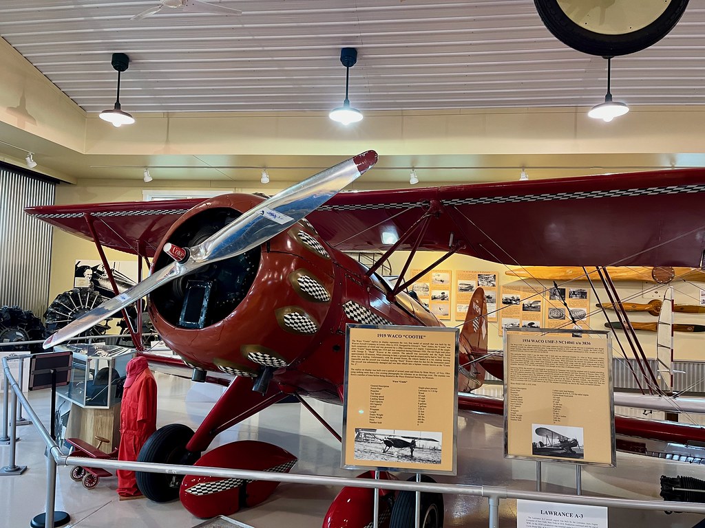
You thought we were done with museums on this trip? Absolutely not, that last article was only about museums in Dayton. There were plenty more out there and we stopped at anything remotely related to aviation. And naturally that included the WACO Air Museum and Aviation Learning Center in Troy (map).
I’d never heard of WACO airplanes before, an acronym for Weaver Aircraft Company. Nonetheless there was a time in the late 1920’s when this was the most popular civilian aircraft manufacturer in the world, based right there in Troy. Later, the company built a steady supply of troop/cargo gliders (CG-4A) for the U.S. military during the World War II. Unfortunately the company never regained its footing after the war and it faded into obscurity within a few years.
By the way, I think WACO is pronounced like Taco, not like the city in Texas or like a crazy person.
Eldean Covered Bridge
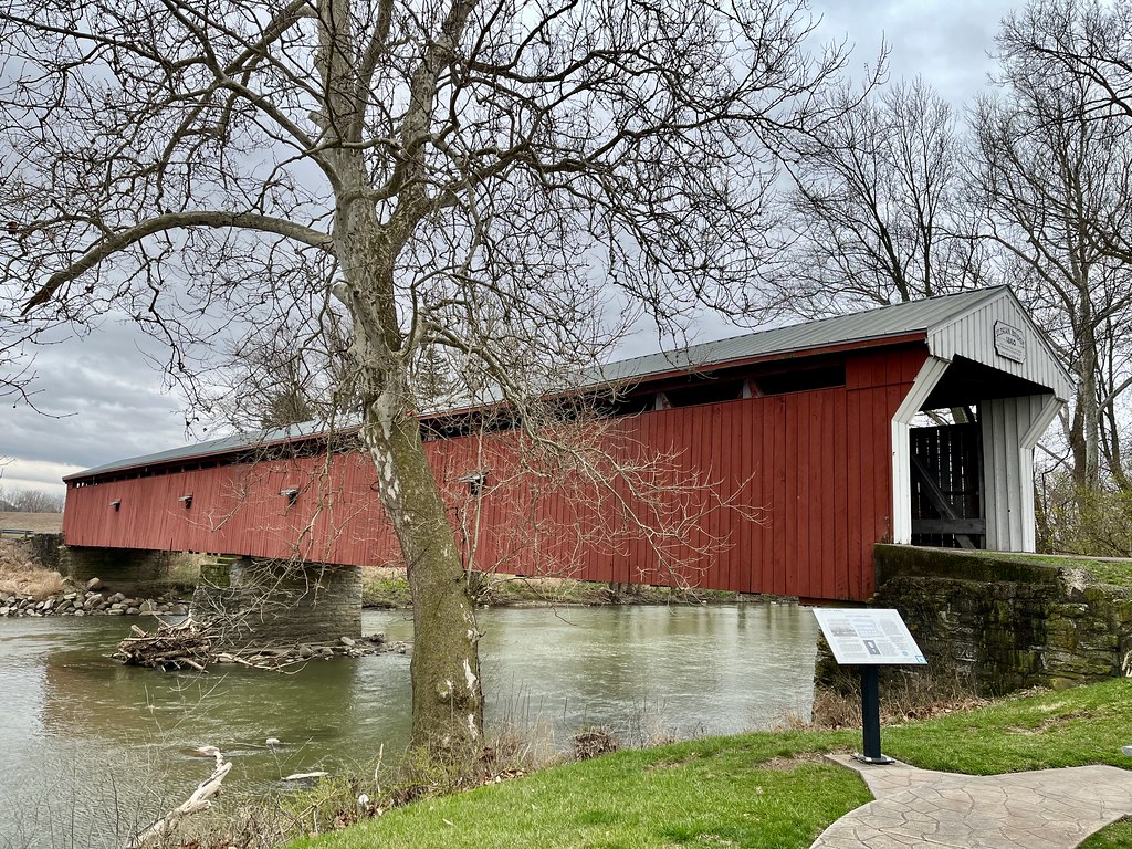
Now everyone needs to prepare themselves for lots of bridges. The Twelve Mile Circle audience knows I enjoy covered bridges and fortunately Ohio has a surprisingly steady supply of them. The Eldean Covered Bridge appeared first on our travel itinerary (map), just up the road from the museum.
This one is longer than most at 224 feet (68 metres) and crosses the Great Miami River. It dates to 1860.
Shelby County
Next we continued nearly due north and entered Shelby County. I’m sure there are interesting things to see there but not so much along our intended route. So I struggled to find anything in Shelby as I planned the drive until I noticed another bridge. No, it wasn’t covered although it was indeed a bridge and sometimes that’s enough.
Big Four Bridge

It looks pretty massive and it’s entirely concrete (map). That counts for something, right? They called it the Big Four Bridge and it just celebrated its 100th birthday (as of 2024). The name references the Cleveland, Cincinnati, Chicago and St. Louis Railway (a.k.a. the “Big Four Railway”) whose trains passed through here, using it to cross the Great Miami River. But why did they need something so impressively enormous? Because a flood in 1913 washed away an earlier, less robust bridge.
It dawned on me that I’ve seen an even more impressive Big Four Bridge somewhere else, also named for the same Big Four Railway. It crosses the Ohio River between Louisville, Kentucky and Jeffersonville, Indiana. I wondered if there are other Big Fours out there too.
Well, that about covered my visit to Shelby County.
Logan County
Next came Logan County at the northern crest of my oblong journey, now heading towards its seat of local government, Bellefontaine. I wasn’t in search of its namesake “Beautiful Spring” nor would I know where to look if it still existed two hundred years after its founding. I only knew that we needed to stop for lunch and we got to Bellefontaine at the right time.
Oldest Concrete Street
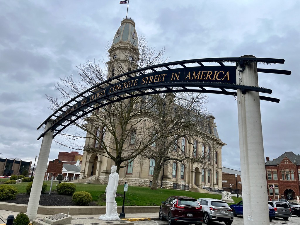
So if we had to stop we might as well park on the “Oldest Concrete Street in America”. By that I mean it was the first street paved in this manner (1891) but of course it’s been repaved any number of times since then. The original concrete is long gone. Nonetheless, Bellefontaine seemed really proud of this one-block segment of Court Avenue (map) and I wasn’t about to get pedantic on them. This piece of oddball Americana was good enough for me.
Even so there was something much more interesting on the eastern edge of Bellefontaine, just a couple of miles away.
Campbell Hill
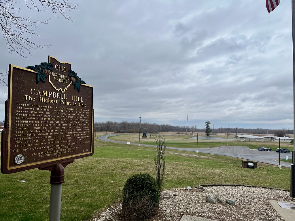
I’m talking about the highest point of elevation in the entire state of Ohio. Campbell Hill (map) will never be mistaken for Denali and the summit isn’t exactly impressive, but it still counts as a state highpoint. I could scratch another one off my list.
It’s my favorite kind of highpoint; the drive-up kind, and it sits on the campus of the appropriately named Ohio Hi-Point Career Center. A driveway leads up to a small parking area maybe ten steps away from the summit. There I stood at an exhilarating 1,549 feet (472 metres) above sea level, higher up than any other human being within the entire state of Ohio.
Union County
Turning the corner and now heading in a southern direction back towards Dayton, I clipped a tiny corner of Union County. Even so that small segment was particularly target rich, with three covered bridges neatly lined up along my path in less than two miles.
North Lewisburg Bridge
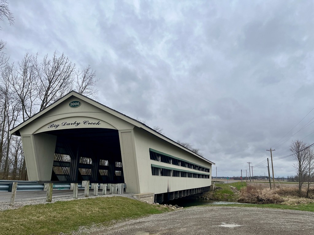
Yes, people still build covered bridges. This isn’t the first time I’ve run into one of these modern throwbacks in a rural corner of the Midwest. They seem to exist more as tourist attractions than to protecting the bridge deck from the elements. Case in point, the North Lewisburg Bridge over Big Darby Creek dated to 2006. Certainly 21st century bridge building techniques have progressed beyond the need for a roof, but doesn’t it look nice?
Pottersburg Bridge
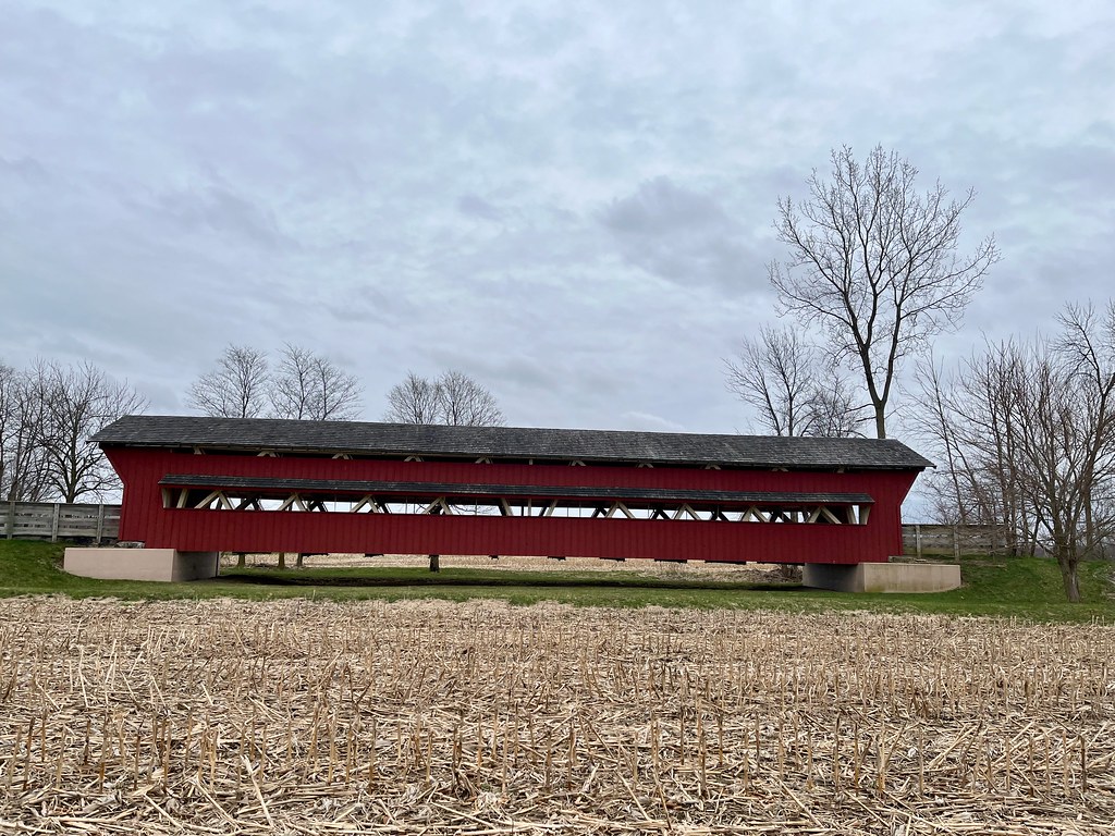
On the other hand, the Pottersburg Bridge is truly vintage, built in 1868. But it crosses nothing! It sits in a field and the “road” across it is actually a paved multi-purpose trail. How fun it must be to ride a bicycle from the nearby town of North Lewisburg and cross the bridge. Here’s the thing though — it used to be located on the spot now occupied by the North Lewisburg Bridge. It’s 1868 timbers couldn’t support automobile traffic anymore so they moved it to a safer place.
Spain Creek Bridge
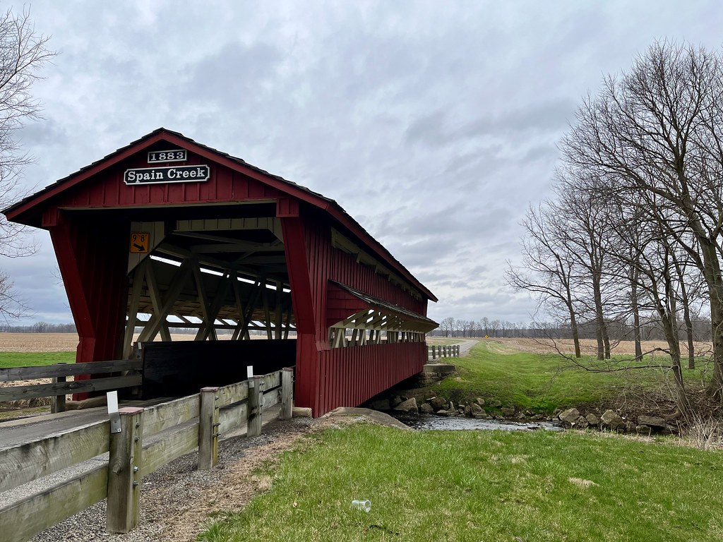
So we continued on our way and approached the Spain Creek Covered Bridge, which crossed — you guessed it — Spain Creek. That’s a tributary of Big Darby Creek. This bridge stretches only 64 feet (20 metres) so it’s pretty short. It also underwent a complete renovation a couple of decades ago that strengthened it for modern vehicle traffic. A sign at the site describes the improvement as “a bridge inside the covered bridge”. The original 1866 structure carries only its own weight.
Champaign County
We hit the home stretch, getting closer to finishing the loop as we passed into the final county. I should have popped a bottle of Champaign when we entered Champaign County after a successful day of County Counting but we still had one more place to go.
Champaign Aviation Museum
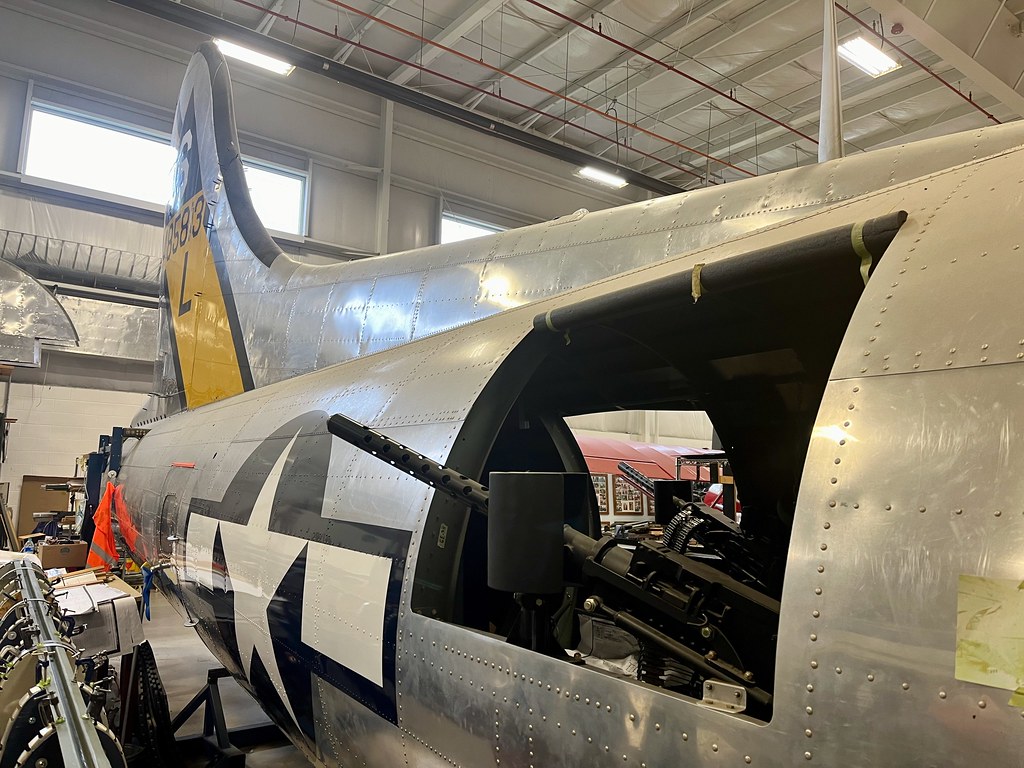
The Champaign Aviation Museum sits on the grounds of the municipal airport in the town of Urbana (map). We saved the best for last at least according to my younger son. The facility features several aircraft but it specializes in the restoration of B-17 “Flying Fortress” bombers from World War II. Better yet, visitors can walk right up to where the work is being done and talk to the people doing it.
Then we finally returned to Dayton and we managed to nail the balance between attractions and distance. It was a rare time when everyone seemed to appreciate the drive.
Articles in the Dayton, Ohio Series
See Also: The Complete Photo Album on Flickr
Leave a Reply