
I expected to run into a ton of Civil War history during my excursions. After all, the first shots of the conflict happened nearby at Fort Sumter in Charleston Harbor. So it surprised me to see a lot less than I figured within the pocket I explored. There was some of course, but not much relatively speaking. Much of it seemed to concentrate further north or further south, or closer to the port cities.
However that didn’t mean the area lacked military connections. I found plenty of threads stretching all the way from colonial times through the present. I’ll cite a few of those in approximate chronological order.
Battle of Eutaw Springs

In an earlier article I mentioned that the Revolutionary War overshadowed the Civil War here. I’m going to continue to dangle that out there. There will be an entire article devoted to the Swamp Fox, I promise. So hang in just a bit longer.
Much of what happened here during the revolution amounted to little more than skirmishes and harassment. True, it forced the British to keep more troops down in South Carolina and away from the main event, so from that perspective it proved effective. But it didn’t have the same level of intensity as other fronts. Even so there were a handful of genuine conflicts in the lowland communities, such as the Battle of Sullivan’s Island and the later British seizure of Charleston.
I visited the site of one of the last major clashes, the Battle of Eutaw Springs (map) which took place in September 1781. It was essentially a draw although the weakened British troops retreated to Charleston where they remained on the sideline for the last couple months of the war. So essentially it marked the end of the Revolution in South Carolina.
Beaufort Arsenal
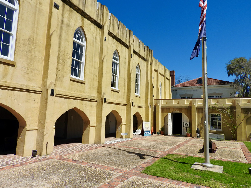
Then I shifted to the interwar period between the Revolution and the Civil War. The United States continued to remain vigilant during that time and even endured that nasty War of 1812. However, that conflict barely touched the Carolinas. Even so, the military retained a presence just in case because of course one never knows when troubles may arise.
For example, the city of Beaufort sat beautifully situated behind a protective barrier island. Any seaborne enemy — and here that meant the British — would love to occupy it. So the state built an arsenal in 1798 as a base for the Beaufort Volunteer Artillery (map). Funny thing, the British never attacked but the United States did. Right, the volunteers from this location supported the Confederacy during the 1861 Battle of Port Royal. Then Union forces promptly captured the coastal enclave and held onto it for the rest of the war.
Today the Beaufort History Museum occupies these grounds. I loved strolling around outside although I never went inside due to the pandemic. It was open though.
So let me skip to the present for just a moment. Just 10 miles to the south sits Parris Island where every Marine Corps recruit undergoes basic training. I threatened to leave my younger son there.
CSS David
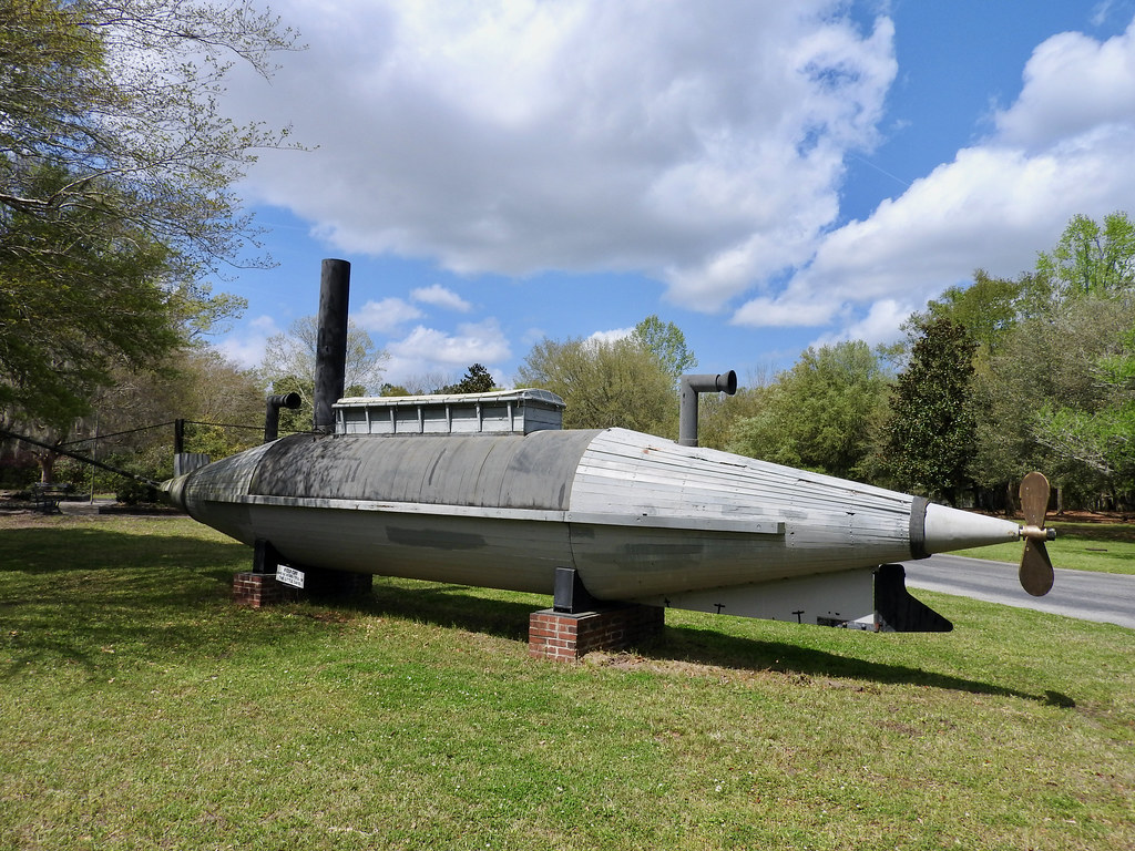
Although not a lot of Civil War history happened in my target area, I did find some. It would be difficult to completely avoid all evidence of the conflict in a Southern state. For instance, I came across a really interesting object at Old Santee Canal Park right in front of the Berkeley County Museum (map).
Here sat a complete life-sized replica of the CSS David. This wasn’t a submarine. Think of it more as a semi-submersible. The boat rode very low in the water, practically invisible on a dark, moonless night. Confederates designed the David, and a handful of identical vessels, to attack Union vessels blockading Charleston harbor. It had to sneak right up to a ship in order to deploy an explosive devise attached to a 25-foot pole.
It sort-of worked. Once. The David damaged a Union ironclad ship called the USS New Ironsides in 1863. She or other boats within the same class made a couple of additional attempts the following year with less success. Either she couldn’t get close enough or the torpedo failed to detonate. Fascinating concept, though.
Fort Fisher
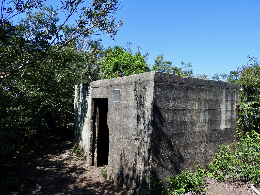
Fort Fisher in North Carolina also figured into the Civil War and fairly significantly. The Confederates used its strategic location to protect the Atlantic and Cape Fear River approaches to Wilmington. Unfortunately I could only take an exterior photo because the state closed this part of the park on Good Friday. So I found a little taste of World War II instead.
That happened along the Basin Trail where I explored an ammunition bunker from that era along our hiking route (map). The U.S. military used this beach extensively to train soldiers on firing ranges. The bunker itself seemed rather sparse, just a barren concrete square with a doorway. However it was good enough for a hermit to call it home for many years.
See the little plaque near the doorway on the exterior wall? It was dedicated to Robert Harrill. I’ll let the plaque explain.
“Robert E. Harrill ‘The Fort Fisher Hermit’ called this deserted WWII bunker home from 1956 – 1972. He attracted thousands who shared his views of society, government and the need for ‘common sense.’ His body was found the morning of June 4, 1972. His death is unsolved (yet). His grave is at the Federal Point Cemetery. The Hermit Society 1995.”
There’s a society of hermits? That sounded completely contradictory. I would think, by definition, a hermit would want to avoid any kind of social organization. Oh, and Mr. Harrill had quite the extensive Wikipedia bio for a hermit, a higher word count than a lot of celebrities. He seemed to have quite a following for someone living in a bunker.
USS North Carolina

Let’s stick with World War II for a little longer. One huge artifact dominated the Wilmington waterfront, the USS North Carolina (BB-55). This ship came online just before the war began. She saw extensive action in the Pacific campaign and remained in service for the duration. Then she went into the reserve fleet and finally became a museum in 1962 (map).
I was surprised that they let us walk all over the ship given the pandemic, even onto some constricted interior decks. And it was crowded too! I’d already been vaccinated by that point and it still made me nervous. Sure, everyone had to wear masks but it felt a bit risky to me especially inside the confined turrets. Other visitors apparently begged to differ and I never heard about any super-spreader events. Maybe I was overly-cautious.
Osprey

A wonderful airplane appeared above us as we toured the deck of the USS North Carolina. I never take photos this good so I’m pretty pleased with how it turned out. Anyway, it’s a taste of the modern-day military, a V-22 Osprey. This is the plane that was replacing the C-2 Greyhound I took when I landed on the aircraft carrier USS John C. Stennis a couple of years ago.
I’m not sure why it happened to fly directly over Wilmington. There’s a Marine Corps Air Station just up the coast (New River). They use Ospreys. So maybe it came from there? It didn’t mater, I simply enjoyed watching this odd airplane/helicopter hybrid in flight.
Articles in the Carolina Wetlands Series
- Padding the Count
- All About the Water
- The Great Outdoors
- This Means War
- The Swamp Fox
- Ruins and Tombs
- Breweries During COVID
- Rounding it Out
See Also: The Complete Photo Album on Flickr
Leave a Reply