
There are 58 counties in California – “The Golden State“
Also be sure to see my United States County Counting Page for the rest of the states.
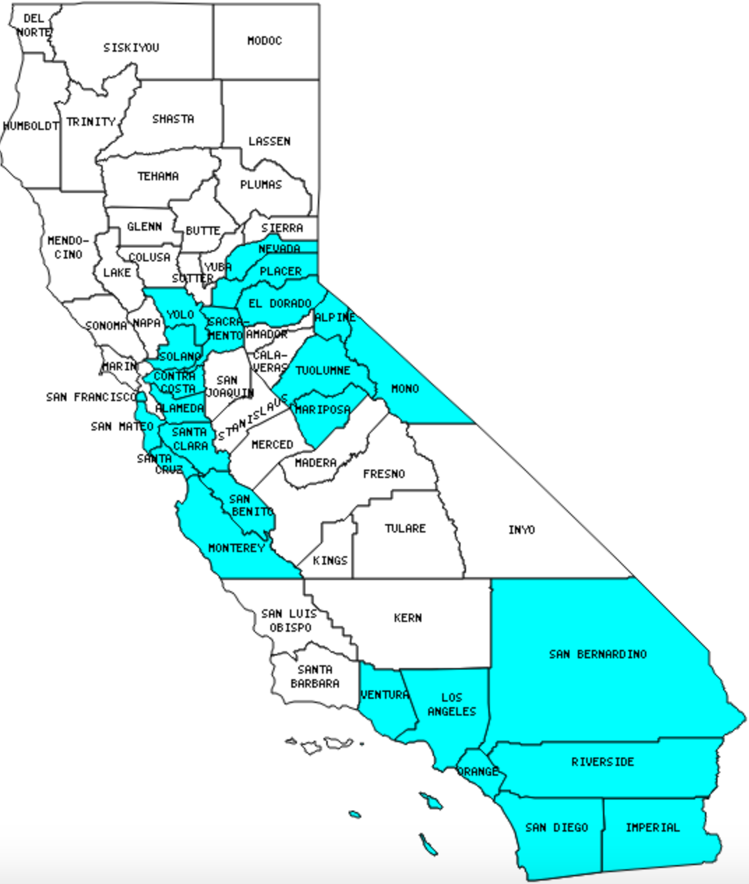
I have visited 25 Counties = 43.1% of Counties in California
Counties visited are colored-in; counties still needing to be visited are blank. Map created using Mob Rule.
Twelve Mile Circle Articles Featuring Places in California
Markers designate the California locations featured in Twelve Mile Circle articles.
Counties in California
Below are the 58 counties in California. Although infrequent, counties sometimes do change so please let me know if any of this information is out of date and I will update it. Those counties that I have visited are highlighted in Red. Readers can also link to any articles manually in this section if the map isn’t working.
- Alameda Other State Nickname Thingies; UC Berkeley
- Alpine: Smallest county population in California (1,208 people in 2000 Census).
- Amador
- Butte
- Calaveras: The Shores of Poker Flat
- Colusa
- Contra Costa: Islands Below Sea Level (Bethel); Port Chicago
- Del Norte: Bigfoot
- El Dorado: Geo-BrEWities; Kanaka Falls; No Way! Way!
- Fresno: Sanitary Landfill Historic Place
- Glenn
- Humboldt: Good Fortuna; Iconic Views
- Imperial: Center of the Universe; Dueling Portmanteau Placenames; Extreme Reservations; How Low Can it Go?; Infrequent Crossings; Plank Roads; Salty, Saltier, Saltiest, Salton; Truckin’ Through California; Imperial Valley Rest Stop; Imperial Sand Dunes
- Inyo: Amazing Road Distances; Chickenfoot Lake; Highest and Lowest, Oh So Close; Lowest Public Restroom in North America
- Kern: Bakersfield – A Better California Capital?; Truckin’ Through California; Where is Spider-Man?
- Kings
- Lake
- Lassen: Mundane First Name Places
- Los Angeles: Largest county population in California and the United States (9,515,338 people in 2000 Census); King Boring and the Detroit Gems; Mount Lukens; Rise and Fall of Idahome; 132 and Bush; 90210: Myth and Reality; As the Bird Flies; Convergence at the End; Electric Avenue; How Often Does This Get Stolen?; How Tautological; Label Me Elmo; Los Angeles with a Toddler; Penciling-In Reagan; Pre-Nazi Swastikas; Presidential Distances; Rock Bands with Geographic Names; Studios to Towns; The Oddity That Got Away; Thoughts on Los Angeles and Reno; Truckin’ Through California; Would You Believe?
- Madera
- Marin
- Mariposa
- Mendocino: Hawaii is Closer than you Think; International Latitude Observatories
- Merced
- Modoc: Surprise Valley
- Mono: Aurora: A County Seat in Two States. Simultaneously!
- Monterey: Giant Artichoke
- Napa
- Nevada
- Orange: Automatic Geolocation; Comedy Duos; Gargantuan Garages; Keep it Moving; Nixon Presidential Library; Placentia is Not a Flat Cake
- Placer: Dream Theater; Kanaka Falls; Railroads Torment Colfax
- Plumas
- Riverside: Agua Caliente Band of Cahuilla; Corona’s Unusual Ring Road; Frank Sinatra’s Drive; He Went Thata Way; Presidential Deaths; Original Navel Orange; The Smallest Tribe
- Sacramento: Worst State Capital Location
- San Benito
- San Bernardino: Largest county in California (20,062 square miles). Longest Distance – Simplest Directions; Ontario; Right Up to the Line; Truckin’ Through California; Zzyzx
- San Diego: Coronado Brewing Company; La Jolla Coast, San Diego Zoo and Wild Animal Park; Intertwining Threads; Karl Strauss Brewing Company; One Flew Over the Void; Pick a Lane. Any Lane; Connecting Through Midway; Zoos & Brews
- San Francisco: Smallest county in California (47 square miles); 21st Amendment Brewery Cafe; Anchor Brewing Co; Gordon Biersch Brewing Company; Make my Trip; San Francisco Brewing Company; Thirsty Bear Brewing Company; This Tour Made Possible by… You; Twenty Tank Brewery
- San Joaquin: Worst Commutes in the USA
- San Luis Obispo
- San Mateo
- Santa Barbara: Creative Marketing; West Coast Sunrises over Water
- Santa Clara: Glasgow or Madrid?; Mountainous Claims; No Name Uno Road; Twelve Mile House; Western Surname
- Santa Cruz: Natural Bridges; Rock Bands with Geographic Names
- Shasta: Remarkable Sundials; Survivors Hill
- Sierra: Poker Flat
- Siskiyou: Bogus; Truckin’ Through California
- Solano
- Sonoma: More Geo-BrEWities
- Stanislaus: Aspirations Court; Warp Drive
- Sutter
- Tehama
- Trinity
- Tulare: Highest and Lowest, Oh So Close
- Toulumne
- Ventura: Kiloanomaly
- Yolo
- Yuba
Quick Facts About California
- Location: Pacific Coast United States. See map above.
- Size(1): 155,779 square miles. California is the 3rd largest state. The next larger state is Texas and the next smaller state is Montana.
- Population(2): 39,551,045 people. California has the largest population of any state. The next less populous state is Texas.
- Population Density: 253.9 people per square mile. California is the 11th most densely populated state. The next more densely populated state is Ohio and the next less densely populated state is Illinois.
- Bordering States: California shares a border with 3 states: Arizona, Nevada and Oregon.
- Admission to the Union: September 9, 1850. California was the 31st state admitted to the Union, after Wisconsin and before Minnesota.
- Capital: Sacramento.
- Highest Point: 14,494 feet at Mt. Whitney. See SummitPost’s Mount Whitney page.
- Lowest Point: -282 feet at Death Valley.
- Government website: ca.gov.
- Official Tourism website: California- Dream Big.
- Still not enough? See Wikipedia’s California page.
Sources:
(1) Wikipedia: List of U.S. states and territories by area. Land area only.
(2) Wikipedia: List of states and territories of the United States by population. Estimated population on July 1, 2019.
Leave a Reply