
I’d heard of Bogue Banks prior to my recent trip although I’d never traveled there before. On the other hand I’d spent extensive time a little farther north up the coast on North Carolina’s Outer Banks. This time I wanted to try something new. Then I felt I should dig a little deeper into the underlying geography so I could understand it better.
Geographic Orientation
Let’s start with Carteret County and drill our way down. Notice that Carteret sits along a centralized portion of coastal North Carolina. Morehead City and Beaufort serve as its primary population hubs and as active ports.
Obviously the county includes extensive Atlantic coastline, as clearly indicated on the map. This encompasses a nearly unbroken swath of barrier islands as well as land protected by resulting sounds. Locals call this whole conglomeration — islands, sounds, waterfront mainland — the Crystal Coast. Even so, it’s more of a marketing ploy than a recognized geographic designation. It’s also not particularly precise. Some tourism officials extend the definition as far south as the mouth of the New River in neighboring Onslow County.
So now focus on Carteret’s barrier islands. Most of them are uninhabited and form the Cape Lookout National Seashore. However we didn’t explore any of those because access was limited during the winter. Instead we focused on the one barrier island where people lived, Bogue Banks. It’s the farthest west of the strand and stretches about 21 miles (34 km).
Bogue Banks is long and skinny. Think of it like the shape of a French baguette. Developers eventually came along with a figurative bread knife and cut it into slices. This formed delineated communities: Emerald Isle; Indian Beach; Salter Path; Pine Knoll Shores; and Atlantic Beach. We rented a house for the week in Pine Knoll Shores.
A Genuine Geo-Oddity
Perhaps you noticed from the map that Bogue Banks extends east-west. That’s a bit of a paradox along the Atlantic coast where one expects the shoreline to run north-south. So, as we gazed upon hypnotic ocean waves from our beachfront home, we were actually looking almost due south. Naturally that messed with my directional orientation the entire week.
Throwback
However, that’s not the best part! I always consult Twelve Mile Circle before every trip to see if I’ll travel near anything we’ve discussed before. My research found a single mention of Pine Knoll Shores, an observation from reader “Brant” in 2012. He referenced an even earlier article, Sunrise and Sunset over Water from 2010. The premise involved places on dry land where someone could see a sunrise and a sunset over water at the same spot on the same day.
In turn that article referenced even earlier articles. Back in 2008 I examined east coast sunsets over water and west coast sunrises over water. For some reason they all fascinated me. So now the thread led back to some of the earliest, ancient layers of 12MC. I felt like an archaeologist.
Anyway, Brant said Pine Knoll Shores displayed a coveted sunrise and sunset over water during the autumn and winter. Hey! I was in Pine Knoll Shores! Maybe I could see it.
Evidence
We were blessed with spectacular weather and clear blue skies for much of the trip. With that, I got up early the morning of December 23, 2021 and I saw this:

Yes, that’s a sunrise over water. No doubt about it. Just me, a few seagulls and the sun peeking over the horizon. But could I replicate the feat that evening?
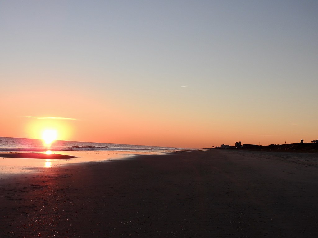
Yes, sure enough, sunset at the same spot on the same day and it happened over water. In fact, the sun remained over water the entire day from this location. It never ventured over land. I marveled at the conditions that had to line-up to make this possible. Recall, the island ran east-west; a highly unusual configuration on the east coast of the United States. Additionally, this was just a couple of days after winter solstice so axial tilt approached its maximum extreme. Both had to align to make this happen.
I’ve never experienced this phenomenon before so I definitely appreciated the opportunity.
Other Interesting Stuff
I’ll reference the slices of the baguette analogy one more time. Unfortunately it wasn’t perfect. Poor Indian Beach fell into two distinct portions, with an intervening slice in the middle. That was the unincorporated enclave of Salter Path, the oldest settlement on the island.
I loved the history behind it. People trickled-in during the latter half of the 19th Century and the early part of the 20th Century. However, they were squatters; they just moved in without permission. Later court decisions allowed them to remain at Salter Path although their descendants didn’t get title to the land until the 1970’s. But that was good enough to keep it out of the hands of developers. So summer tourist towns sprang-up everywhere else but Salter Path remained Salter Path.
Also, nobody truly knows how the island got its name. All sorts of theories existed. For example, various dictionary definitions of bogue implied aimless or slow movement, or water passages like a stream. So your guess is as good as mine. It’s been around since the early 18th Century, though.
Running the Banks
This really has nothing to do with the rest of the article. Nonetheless I had to shoehorn it in somewhere and this seemed as good a place as any.
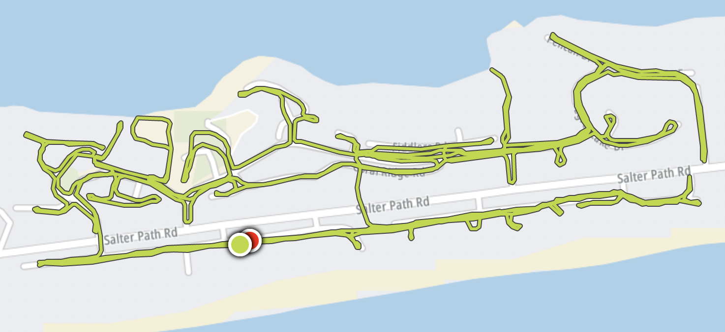
I managed a couple of runs during the trip so I could keep physically active and work off some of those holiday pounds. One was a 5 mile out-and-back on a paved trail further down the island. It involved driving and parking and a boring trot along the side of a busy road.
The second was 10 miles and that’s the map above. Salter Path Road had narrow shoulders and lots of traffic at that point so I confined myself to the immediate neighborhood. It was a lot more interesting than the out-and-back and I think I covered every nook and cranny something like three times. Not that anybody cares. But the delta between the GPS track my running watch recorded and the infrastructure displayed on the map did fascinate me.
Articles in the Bogue Banks Series
See Also: The Complete Photo Album on Flickr.
Leave a Reply