
The Korean War never actually ended. Rather, it froze in place at an armistice line on July 27, 1953. So there’s a multi-decade ceasefire, a truce, but no agreed-upon resolution of hostilities.
A four kilometre wide Demilitarized Zone acts as a buffer between North and South Korea near the 38th parallel north. It crosses the the entire peninsula for 250 kilometres and keeps the two sides separated like a referee in a boxing match. However there is a single point within the DMZ where the two come face-to-face, a tense coiled spring that is supposed to act as a relief valve: the Joint Security Area.
This was the capstone of my recent visit to military facilities in the Asia-Pacific region. I spent my final full day in South Korea traveling within the Demilitarized Zone and the even more restricted Joint Security Area.
Even the soldiers stationed there remarked about the perfect weather that day. I’m not sure what I did to deserve it but I was happy to enjoy it. Crisp, cloudless, smog-free skies let us peer much deeper into North Korean territory than usual.
The Third Tunnel
Surprisingly, it’s not all that difficult to get into the DMZ. No, someone can’t just randomly drive in but all sorts of private tour companies offer nicely packaged half-day or full-day bus trips. It blew my mind. This ribbon sits on the precipice of full-blown warfare at any given time, a military volcano waiting to erupt. Yet, busloads of school kids cross into the DMZ every day like it’s a barbed wire amusement park.
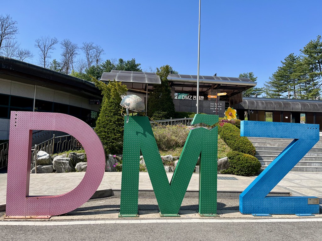
One of the typical stops is The Third Tunnel (map). Unfortunately they don’t allow photos of the actual tunnel so instead I’ll post this whimsical DMZ sign found near its entrance. Instantly Instagramable and ready for selfies! See what I mean? Deadly serious but completely normal.
As the name implies, it was the third (of four) tunnels discovered crossing into South Korea. Perhaps as many as 30,000 invaders per hour could fit through here when completed. But we’ll never know because South Korea discovered the tunnel and blocked it in 1978. Even so, here’s an uncomfortable thought: there may be as many as twenty more tunnels still waiting to be found.
I walked down into the depths, wearing a hardhat because of the particularly low ceiling. Invariably everyone bangs their helmet, probably multiple times, and bonk-bonk sounds echo down the tunnel. Then at the end of the path looms the first of three concrete plugs preventing North Korean aggression. So I probably got within about fifty metres of the subterranean border but no closer. That’s where everyone has to turn around and go back to the surface.
Dora Observatory
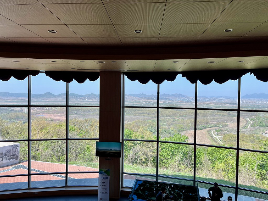
Typically, DMZ visitors also stop at the Dora Observatory (map). The indoor pavillion features amphitheater-style seating behind a large picture window. See the person at the bottom-right side of the photo? That gives a nice sense of scale. This would be a great place to hang out during bad weather or if someone hates the outdoors or something. The mountains on the horizon are in North Korea. So are most of the plains. You can see a little ribbon of the border on the right side about halfway up.
A similar scene unfolds outside too. However, out there the viewing platform includes a row of industrial strength binoculars so people can spot actual North Koreans doing North Korean things on the other side of the border, like riding a motorbike or walking along the top of a dyke. Well, that’s what we saw. Oh, and here’s another uncomfortable thought: North Koreans could easily place artillery down there and pulverize Seoul. It’s only about 50 kilometres away.
This is where the tour ends for most visitors.
The Joint Security Area
But I wasn’t “most visitors”.
I participated in an escorted tour of the Joint Security Area, an even further secured area within the DMZ. It felt almost like entering a prison actually, with huge razor-wire fences and guards armed to the teeth. Public tours of the JSA exist although they book rather quickly. It’s probably easier to get in via United States Forces Korea or the United Nations if one has those connections. Arrangement were made on my behalf so I don’t know exactly how the process works.
Anyway, it almost didn’t happen. Our guide finished briefing us on rules we needed to follow before entering the JSA. Things like: only take pictures when they say it’s okay; don’t wander from the path; don’t wave at anyone across the border; and act normal. Basically, follow all instructions and don’t play the fool. But then another soldier walked over and whispered to our guide for a few minutes. There had been an “incident” in the DMZ.
Any tiny deviation from normal is an incident. A spontaneous brush fire had flared-up a few kilometres away so U.N. Forces directed a helicopter to dip a bucket into a nearby river to put it out. Even that small disruption could be enough to freak-out the North Koreans.
I thought for sure this would cancel our tour of the JSA after we got all the way to its literal doorstep. But no! We waited a few minutes and then proceeded. Maybe canceling a tour might also be an “incident” if North Koreans expected to see a bunch of visitors tromping through the JSA? So keeping the tour signaled normalcy? I don’t know
Bridge of No Return
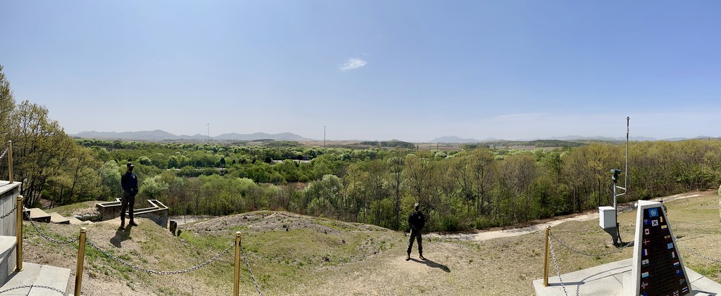
There’s a knoll near the southwestern corner of the JSA, on the United Nations side. We stopped there first for some amazing views into North Korea. That’s where I took the panoramic shot displayed elsewhere on this page — it’s big and detailed so feel free to open it in another tab. South Korea stops at the grassy area and North Korea begins at the trees. Yes, we were exceptionally close to the border at this point.
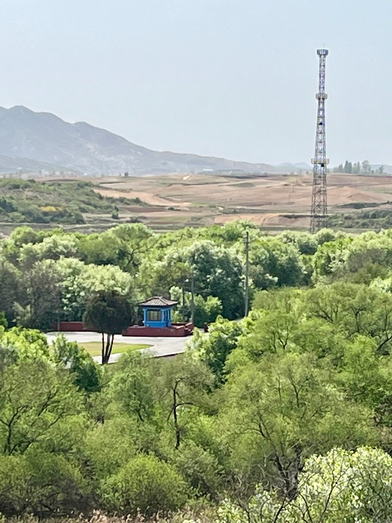
A small blue guard post appeared downhill. It stands sentinel on the U.N. side of the “Bridge of No Return” where prisoner exchanges occurred after the armistice (map). Prisoners got a choice: they could stay on one side of the border or cross to the other. However, if they crossed they could never go back. The guard post also has a nickname, the “Loneliest Outpost in the World” because it’s surrounded by North Korean territory on three sides. The post is no longer active and a chain blocks access to the bridge, now marked with landmine warnings.
Truce Village

I guess the whole JSA qualifies as “truce village” although there’s an inner core with several buildings. Sometimes it’s called Panmunjom but that’s erroneous. The actual Panmunjom was a small village located nearby on the North Korean side. Regardless, this is where both sides meet when they need to talk in person. The border runs directly through four of the buildings including the two blue buildings, above. Look between the buildings where a concrete slab separates the gravel and paved portions. That is the border (map).
The building in the background is Panmungak, the main headquarters on the North Korean side. So close and yet we never saw a North Korean soldier during our visit. Apparently they stay inside Panmungak because of COVID concerns, anonymously snapping our photos from behind darkened windows.
Inside Building T 2
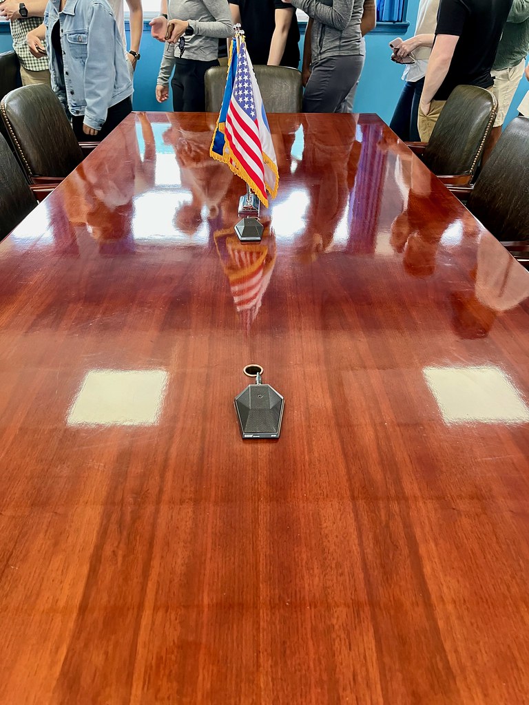
Then we entered one of the blue buildings, the one called T 2. Here the border goes right through a conference table and directly across the microphones. During meetings, North Koreans sit on the left side and South Koreans sit on the right in this photo, and they share home field advantage. Of course this meant I straddled the border when I took the picture; split in two by the armistice line.
We roamed freely inside — it was a U.N. building despite the territorial overlap. So I probably spent about ten minutes of my life in North Korea. And that also makes it eligible as one of the very small number of places I’ve visited solely on foot. Better yet, I’ve only been to North Korea indoors.
Never in my life did I imagine I’d ever enter North Korea and even now it feels like something from dream. I’m glad I have photographic proof!
Articles in the Asia-Pacific Series
- Oahu: Honolulu Waterfront
- Oahu: Beyond Waikiki
- Japan: Tokyo Temples and Tourists
- Japan: Exploring Tokyo
- Japan: Farther Afield
- South Korea: Seoul
- South Korea: The DMZ
- Postscript: Interesting Signs
- Postscript: Brew It
See Also: The Complete Photo Album on Flickr
Leave a Reply