
There are 88 Counties in Ohio – “The Buckeye State“
Also be sure to see my United States County Counting Page for the rest of the states.
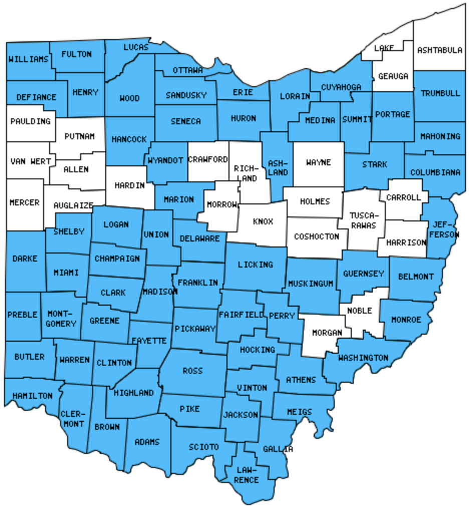
I have visited 88 Counties = 100% of Counties in Ohio
Counties visited are colored-in; counties still needing to be visited are blank. Map created using Mob Rule.
Twelve Mile Circle Articles Featuring Places in Ohio
Markers designate the Ohio locations featured in Twelve Mile Circle articles.
Counties in Ohio
Below are the 88 counties in Ohio. Although infrequent, counties sometimes do change so please let me know if any of this information is out of date and I will update it. Those counties that I have visited are highlighted in Red. Readers can also link to any articles manually in this section if the map isn’t working.
- Adams: Overwhelming Union; Catbird Seat; Serpent Mound
- Allen: Lima
- Ashland
- Ashtabula: Largest county in Ohio (703 square miles). Coal Arch; Doyle Road Bridge; Giddings Road Bridge; Lift Bridge; Netcher Road Bridge; Point Park
- Athens: The Healing Chapel
- Auglaize: Armstrong Air & Space Museum
- Belmont: National Road Marker
- Brown: Augusta Ferry
- Butler: County Tripoint; Exclamatory Towns!
- Carroll
- Champaign: Champaign Aviation Museum
- Clark
- Clermont: Welcome to Utopia
- Clinton
- Columbiana
- Coshocton: Helmick Covered Bridge; Historic Roscoe Village; Monticello III; Pathway to Bedford; That Other Warsaw
- Crawford
- Cuyahoga: Largest county population in Ohio (1,393,978 people in 2000 Census); Great Lakes; Résumé Bait and Switch; Over the Road; Cleveland-Brooklyn Border; Lucky 7 & the Ghost Kid; Diamondback Brewery
- Darke: Disunion Averted
- Defiance: Fort Defiance; The Meridian
- Delaware
- Erie: Quad County Towns, Crowdsourced
- Fairfield: From Camp to Town
- Fayette
- Franklin: Corn Cob Sculpture Field; Alphabetical Circle; Ohio Capitals; The Dreadful Road Trip; Columbus Name Symmetry; Misplaced Romans
- Fulton
- Gallia
- Geauga
- Greene: Battle of Chillicothe; Huffman Prairie
- Guernsey
- Hamilton: Twelve Mile House; Zig Zag; International Latitude Observatories; Sayler Park; Canal Becomes Subway; More Presidential County Sorting; Outside of California; Twelve Mile House; Coney Island
- Hancock
- Hardin
- Harrison: Custer Monument
- Henry
- Highland
- Hocking
- Holmes: Behalt Amish and Mennonite Heritage Center; Highest Religious Affiliation; Stutzman Covered Bridge
- Huron: Quad County Towns, Crowdsourced
- Jackson: The Jeffersons and Beyond
- Jefferson
- Knox
- Lake: Smallest county in Ohio (229 square miles); Overwhelming Union
- Lawrence
- Licking: Basket-Shaped Office Building; Nestling Newark
- Logan: Campbell Hill (Ohio Highpoint); Oldest Concrete Street; Zane Shawnee Caverns
- Lorain
- Lucas: The Other White House, Toledo Zoo
- Madison
- Mahoning
- Marion: Where’s Waldo?
- Medina
- Meigs
- Mercer: Celina Lighthouse
- Miami: Eldean Covered Bridge; Overwhelming Union; WACO Air Museum
- Monroe
- Montgomery: 2nd Street Market; America’s Packard Museum; Carillon Historical Park; Day Air Ballpark; Dead End at Night; Eastwood MetroPark; Germantown Covered Bridge; Minion; Mound Cold War Discovery Center; National Museum of the Air Force; Oregon District; Overwhelming Union; St. Anne’s Hill; Smith Covered Bridge; Wright-Dunbar Interpretive Center
- Morgan
- Morrow
- Muskingum: Ohio Capitals
- Noble
- Ottawa
- Paulding: Paulding Courthouse
- Perry: Hardly Tropic
- Pickaway: Square the Circle; Circleville Survived; Pumpkin Water Tower; Hitler Road
- Pike
- Portage: Streetsboro
- Preble: Bordersplit School; County Tripoint
- Putnam: The Big Bull
- Richland
- Ross: Knockemstiff; Ohio Capitals; Perfect Weather
- Sandusky: Quad County Towns, Crowdsourced
- Scioto: Portsmouth
- Seneca: Jeremiah Good Octagon House
- Shelby: Big Four Bridge
- Stark: Trump Avenue; Overwhelming Union
- Summit: Akron Zoo; Lock 1, Ohio & Erie Canal; Portage Lakes; Summit of Summit
- Trumbull: Clarence Darrow Octagon House; Right Up to the Line; Presidential Distances
- Tuscarawas
- Union: Natural Forces: Magnetism; Overwhelming Union; Union County Covered Bridges
- Van Wert
- Vinton: Smallest county population in Ohio (12,806 people in 2000 Census); Hope Iron Furnace; Oreton
- Warren: Eric Henn Murals
- Washington: Layman; Campus Martius; Mound Cemetery; Capitolium; Front Street; Riverfront Park
- Wayne
- Williams: Lockport Covered Bridge
- Wood: Twelve Mile Square Reservation
- Wyandot
Quick Facts About Ohio
- Location: East North Central United States. See map above.
- Size(1): 40,861 square miles. Ohio is the 35th largest state. The next larger state is Tennessee and the next smaller state is Virginia.
- Population(2): 11,689,442 people. Ohio is the 7th most populous state. The next more populous state is Illinois and the next less populous state is Georgia.
- Population Density: 286.1 people per square mile. Ohio is the 10th most densely populated state. The next more densely populated state is Pennsylvania and the next less densely populated state is California.
- Bordering States: Ohio shares a border with 5 states: Michigan; Indiana; Kentucky; West Virginia and Pennsylvania.
- Admission to the Union: March 1, 1803. Ohio was the 17th state admitted to the Union, after Tennessee and before Louisiana.
- Capital: Columbus.
- Highest Point: 1,550 feet at Campbell Hill. See SummitPost’s Campbell Hill page.
- Lowest Point: 455 Feet at the Ohio River in Hamilton Co.
- Government website: Welcome to Ohio.gov.
- Official Tourism website: Ohio – Find It Here.
- Still not enough? See Wikipedia’s Ohio page.
Sources:
(1) Wikipedia: List of U.S. states and territories by area. Land area only.
(2) Wikipedia: List of states and territories of the United States by population. Estimated population on July 1, 2019.
Leave a Reply