
The Bermuda Railway Trail surprised me in a pleasing way. I saw it on a map before I arrived and I thought it sounded interesting. Actually, it far exceeded my expectations, becoming one of the most memorable parts of my visit.

A Little Context
Residents and tourists alike used horsepower or their own feet to get around Bermuda for most of its history. The British government didn’t even allow private automobiles there until after World War II. However, they did build a railway stretching the entire length of the archipelago that operated for most of the 1930’s and 1940’s. Trains and tracks disappeared ages ago but much of the path formed the basis of Bermuda Railway Trail National Park.
My Routes
I traveled large parts of the trail over a couple of different days. My wife and I walked the entire St. George’s Parish portion from the outskirts of the Town of St. George to the tip of Ferry Point Park and back during one morning stroll (route).
Another day, my wife had to work from her base at the Fairmont Southampton hotel. I rented a bicycle and headed to the trailhead just down the hill (map). The guys at the bicycle shop suggested riding west for the best scenery so I did that just like probably 90% of the other tourists. I went out as far as Scaur Hill and came back for lunch with my wife at the hotel (route). Then for grins I headed east to the segment’s end in Paget Parish and returned home once again (route).
I didn’t get a chance to try any of the North Shore segments. I’ll be sure to finish those if I’m lucky enough to return to Bermuda someday.
Mastering the Terrain
Construction required tremendous effort. Trains need relatively gentle grades and smooth curves, even for the small one- and two-car trains used in Bermuda. This didn’t mesh well with undulating terrain. Builders had to use a variety of techniques to deal with that. I guarantee the railway trail is a lot straighter and more level than any of the modern roads that parallel it, though.
Road Cuts

Construction crews simply dug through hillsides that rose too sharply. I rode past impressive road cuts at many places along the trail. I stopped at this memorable instance in Southampton Parish (map).
My rented bicycle appeared in this image. I chose a Trek mountain bike with nice wide treads that day. It might have been overkill for most of the trail although it did save me from having to dismount a couple of times. A hybrid probably would have been fine although I’d avoiding using a road bike here. Also, stay to the left in Bermuda, even on a trail!
Tunnels
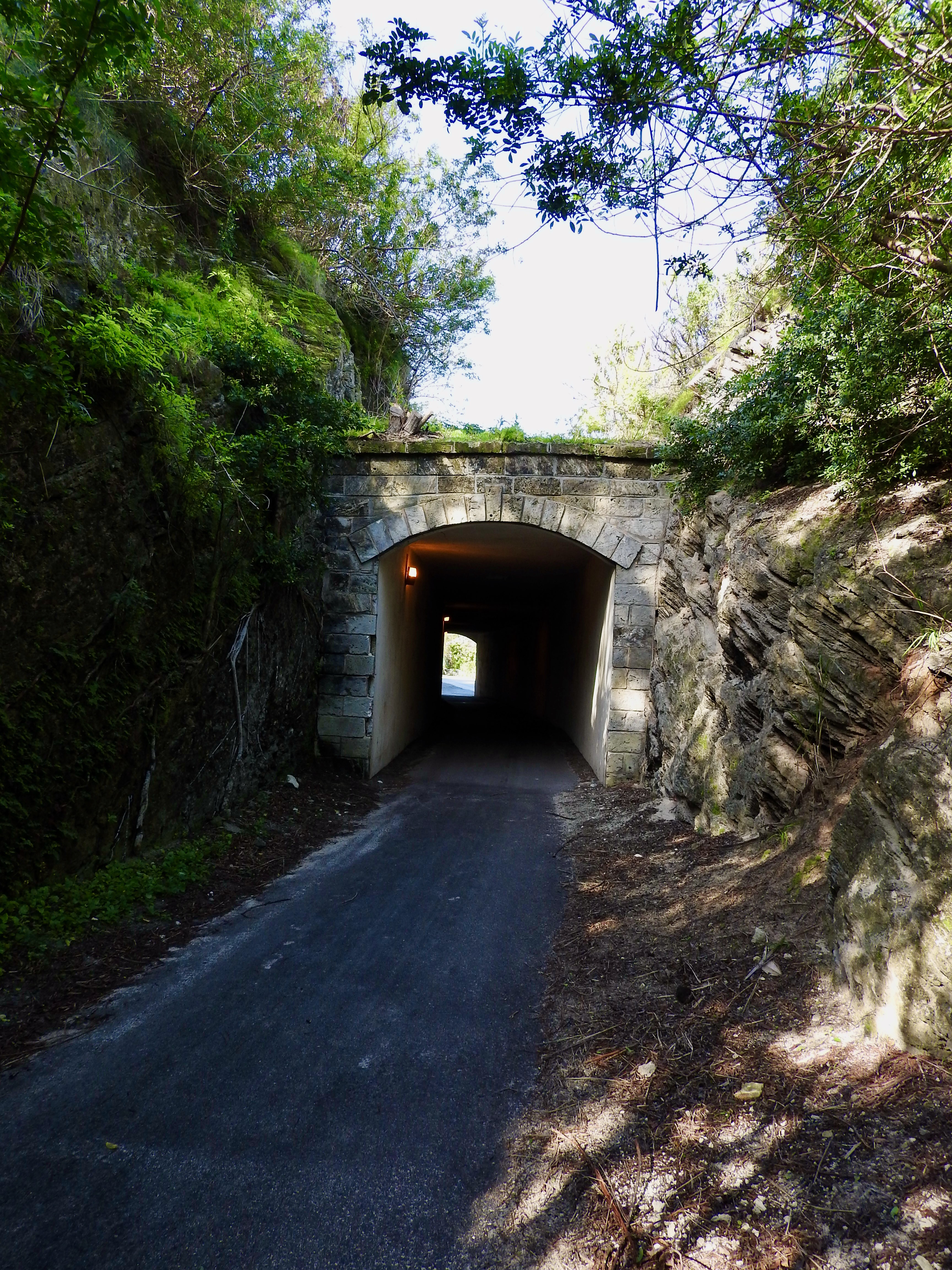
I love tunnels, for example those on the Great Allegheny Passage in Pennsylvania or the Whittier tunnel in Alaska. I found several tunnels along my path including a nice occurrence west of the Fairmont trailhead (map). Most seemed to be road cuts with lids instead of genuinely bored tunnels. Nonetheless, that didn’t matter. I enjoyed riding through them all.
Bridges

Some of the stretches along North Shore Road featured lovingly restored bridges. Unfortunately I didn’t get to visit any of those segments. I did see a former bridge though, long since abandoned and reduced to pilings. I considered the ruins at Ferry Point Park (map) to be particularly scenic. It would be lovely if they ever restored this one. The current causeway connecting the eastern end of Bermuda to the rest of the archipelago is way too dangerous for pedestrians.
Remnants
Rails and ties disappeared from the roadbed a long time ago. I’m sure they became scrap and someone probably carted them away once service ended. Nonetheless, certain historic artifacts remained in place, including some of considerable size.
Stations

For example, even some of the original stations still existed. Riddell’s Bay Station in Warwick Parish (map) served as an excellent case in point. Passengers used to ride to this station and then catch a horse-drawn cart down to a local golf course. Similar arrangements existed at other stations. Tourists could get fairly close by rail. From there, owners of various attractions used traditional horsepower to carry them the rest of the way.
Mileposts

Many of the original mileposts existed too. I saw several of them including the one above located in St. George’s Parish (map). They seemed to mark distance between larger towns rather than individual stations. A number of stations existed between St. George’s and Devonshire, both referenced on the marker.
Historical Markers

I particularly appreciated the frequent historical markers such as this one at the Paget Parish trailhead (map). I didn’t have any particular deadline or agenda. That let me stop at a bunch of signs as I cruised the trail. My photos of various historical markers gave me a pretty good sense of the place:
- St. George’s World Heritage Site
- Passing Loops, Switches and Keys
- Gibbs Hill Lighthouse
- Riddell’s Bay Station
- Tribe Roads
- Elbow Beach Station
- Hamilton
- Time and Cost of Construction
I wish I took more.
Behind the Scenes
I enjoy train travel because it lets me see behind the scenes. People want the world to pay attention to the front of their homes. Yet trains run behind homes, letting passengers glimpse how residents truly live. Forget manicured lawns, water fountains and topiary, I want to see a rusting car on blocks next to a dilapidated shed with peeling paint and a busted window.
I wondered where people of moderate means lived in a place where the average home sold for more than $1.5 million. Well, I found some of them along the segment of trail extending east of the Fairmont hotel and into Paget Parish. Previously I said “it seemed almost impossible to find a place without a spectacular view.” However, a narrow spine sat inland just far enough to defy that claim. The trail followed the spine along this segment. I couldn’t see any water so I focused on scenery of another sort, observing how people lived in places away from the waterfront mansions.
Family Farms

Almost everything in Bermuda arrives from the outside world. Even its famous Goslings rum isn’t distilled in Bermuda, although blending and bottling does take place there along with other locations. So “buying local” would be pointless, except perhaps for for small-batch perfumes or things produced by resident artistsans.
A small amount of agriculture does happen on family farms. Bermuda onions became a thing many decades ago and still exist although I didn’t see where they grew. The fields I saw on my ride (map) might be sweet potatoes? That seemed to be a common crop in Bermuda and my scouring of the Intertubes found photos of plants similar to what I saw.
Skybox

I think I most enjoyed this sight in Warwick Parish (map). The trail went past the Pembroke Hamilton Club Field, home to the PHC Zebras football (soccer) team. Railway excavators dug a level terrace along a steep hillside through this stretch. Now it provides an elevated perch above the stadium.
Enterprising football fans obviously noticed this happy coincidence and created a do-it-yourself skybox of sorts. It featured a wooden deck overlooking the field. On the other side of the trail, where railway construction carved a sheer wall into the hill, fans built a makeshift bar and added a barbecue grill. Several repurposed chairs finished the arrangement. These fans could watch the game in style, cook a meal, relax and just hang out. It must have had at least some unofficial sanctioning too; municipal trash cans had been placed on site along with signs requesting their use.
Nature Along the Trail
Few indigenous animals lived in Bermuda because of its remoteness. Some birds got there. A few lizards, turtles and bats also found there way out prior to humans, but not much else.
Seymour’s Pond

I stopped at Seymour’s Pond (map), an Audubon Society property in Southampton. It’s not huge — less than three acres — although it’s still rather sizeable for a small place like Bermuda. This pond, like most here, stays brackish because sea water filters in through caverns beneath the archipelago. All sorts of little critters thrived in the pond and became meals for seasonal visitors like egrets who overwintered there.
Great Kiskadee

People introduced Great Kiskadees to Bermuda from Trinidad in 1957 to control another non-native species, Anolis lizards. The lizards had been introduced in 1905 to control fruit flies, also non-native. See how it works? The 200 Kiskadees bred and thrived although they avoided the lizards, preferring eggs of one of the few indigenous birds and also probably caused the extinction of the native Bermuda Cicada.
They looked pretty and their distinctive call could be heard everywhere. I happened to spot a Kiskadee as I stopped at Fort Scaur in Sandy’s Parish (map). I couldn’t believe it actually sat there long enough for me to take a decent picture.
Non-Contiguous

My sole minor quibble was the non-contiguous nature of the trail. I had to bike on busy roads and hope that drivers looked out as they approached from behind while I pedaled between segments. Sometimes it wasn’t intuitively obvious where the next segment began either, although I brought a map and figured it out as I went.
Even so, I found some wonderful sites in places where trail and road commingled. The Somerset Bridge in Sandys Parish (map) would be near the top of that list. Tourist material called it the “world’s smallest drawbridge.” I have no way to fact check that. It did seem very small. Only a single tiny personal sailboat with mast would fit through that narrow slot.
I’m grateful for the Bermuda Railway Trail and the attention put into it. Hopefully the Bermudian government will continue to invest in its continuous improvement. I considered it an enjoyable treasure and I’d definitely recommend it
Articles in the Bermuda Shorts Series:
- Follow the Leader
- Shoreline Scenery
- The Outsider
- Bermuda Railway Trail
- St. George
- Forts
- Architectural Details
- Museums & More
- Lists
See Also: The Complete Photo Album on Flickr
Leave a Reply