
There are 92 Counties in Indiana – “The Hoosier State“
Also be sure to see my United States County Counting Page for the rest of the states.
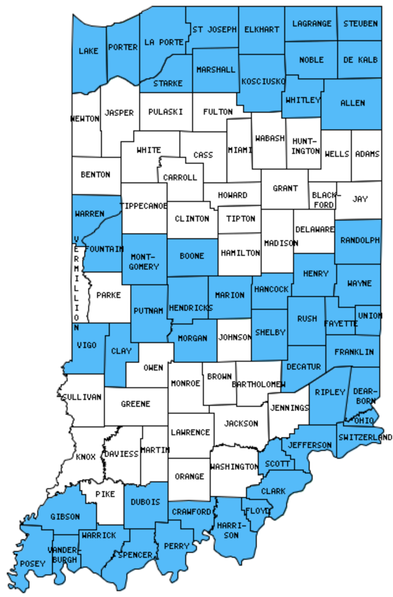
I have visited 51 Counties = 55.4% of Counties in Indiana
Counties visited are colored-in; counties still needing to be visited are blank. Map created using Mob Rule.
Twelve Mile Circle Articles Featuring Places in Indiana
Markers designate the Indiana locations featured in Twelve Mile Circle articles.
Counties in Indiana

Below are the 92 counties in Indiana. Although infrequent, counties sometimes do change so please let me know if any of this information is out of date and I will update it. Those counties that I have visited are highlighted in Red. Readers can also link to any articles manually in this section if the map isn’t working.
- Adams
- Allen: Largest county in Indiana (657 square miles); The Smallest Largest US County; Saint Marys River
- Bartholomew
- Benton: Make a Bee Line
- Blackford
- Boone
- Brown
- Carroll
- Cass: Twelve Mile, Indiana
- Clark: The Big Four Bridge
- Clay: Brazil
- Clinton
- Crawford
- Daviess
- De Kalb
- Dearborn: Aurora; Triple Whipple Bridge
- Decatur
- Delaware
- Dubois: Time Zone Boundary Craziness
- Elkhart
- Fayette: Fayette / Union Border
- Floyd
- Fountain
- Franklin
- Fulton
- Gibson: Interstate 69 Time Zone Crossing
- Grant
- Greene: Nestling Newark
- Hamilton
- Hancock
- Harrison: Indiana Caverns; Original Indiana Capitol; Battle of Corydon; Constitution Elm
- Hendricks
- Henry
- Howard
- Huntington
- Jackson: The Jeffersons and Beyond
- Jasper
- Jay
- Jefferson: Clifty Falls
- Jennings
- Johnson
- Knox
- Kosciusko: That Other Warsaw
- La Porte: Shoreline Brewery; Michigan City Beach & Lighthouses; Chicago-New York Electric Air Line; Indiana Toll Road Time Zone Crossing
- Lagrange
- Lake: Michael Jackson Home; Americana
- Lawrence
- Madison
- Marion: Largest county population in Indiana (860,454 people in 2000 Census); The Dreadful Road Trip; Mmm… Doughnut; Alcatraz Brewing Co.
- Marshall: E. LaPorte St. Footbridge
- Martin
- Miami
- Monroe
- Montgomery
- Morgan
- Newton
- Noble: LaOtto Brewing; Shortline
- Ohio: Smallest county in Indiana (87 square miles) and Smallest county population in Indiana (5,623 people in 2000 Census); Triple Whipple Bridge
- Orange: Larry Bird Boulevard; Lost Rivers
- Owen
- Parke
- Perry
- Pike: Interstate 69 Time Zone Crossing
- Porter: Coffee Creek Fill
- Posey
- Pulaski
- Putnam
- Randolph: Entering Randolph; Overwhelming Union
- Ripley
- Rush
- Scott: Leota Covered Bridge
- Shelby
- Spencer: Santa Claus, Indiana
- St. Joseph: Quad County Towns; Order in the Court; Railroads Torment Colfax; Indiana Toll Road Time Zone Crossing
- Starke
- Steuben
- Sullivan
- Switzerland
- Tippecanoe
- Tipton
- Union: Bordersplit School; County Tripoint; Union/Fayette Border
- Vanderburgh: Mesker Park Zoo; USS LST-325
- Vermillion: Adjacent Counties, Same Name, Different States
- Vigo
- Wabash
- Warren
- Warrick: Boone Scraps
- Washington
- Wayne: Hoosier Hill; Thistlewaite Falls
- Wells
- White
- Whitely
Quick Facts About Indiana
- Location: East North Central United States. See map above.
- Size(1): 35,826 square miles. Indiana is the 38th largest state. The next larger state is Kentucky and the next smaller state is Maine.
- Population(2): 6,691,878 people. Indiana is the 17th most populous state. The next more populous state is Tennessee and the next less populous state is Missouri.
- Population Density: 186.8 people per square mile. Indiana is the 16th most densely populated state. The next more densely populated state is North Carolina and the next less densely populated state is Georgia.
- Bordering States: Indiana shares a border with 4 states: Illinois, Kentucky, Ohio and Michigan.
- Admission to the Union: December 11, 1816. Indiana was the 19th state admitted to the Union, after Louisiana and before Mississippi.
- Capital: Indianapolis.
- Highest Point: 1,257 feet at Hoosier Hill. See SummitPost’s Hoosier Hill page.
- Lowest Point: 320 feet at the Ohio River at Posey County.
- Government website: IN.gov: Home.
- Official Tourism website: VisitIndiana.com.
- Still not enough? See Wikipedia’s Indiana page.
Sources:
(1) Wikipedia: List of U.S. states and territories by area. Land area only.
(2) Wikipedia: List of states and territories of the United States by population. Estimated population on July 1, 2019.
Leave a Reply