
There are 64 counties in Colorado – “The Centennial State“
Also be sure to see my United States County Counting Page for the rest of the states.
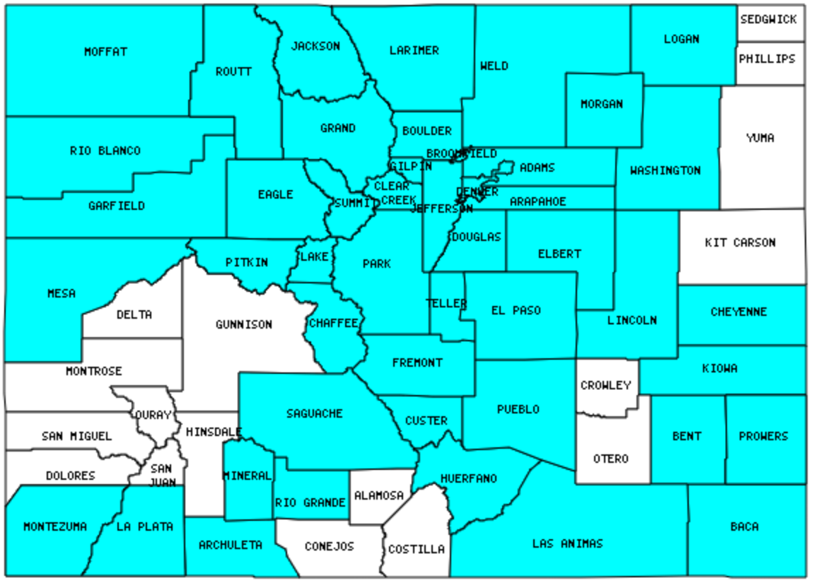
I have visited 47 Counties = 73.4% of Counties in Colorado
Counties visited are colored-in; counties still needing to be visited are blank. Map created using Mob Rule.
Twelve Mile Circle Articles Featuring Places in Colorado
Markers designate the Colorado locations featured in Twelve Mile Circle articles.
Counties in Colorado
Below are the 64 counties in Colorado. Although infrequent, counties sometimes do change so please let me know if any of this information is out of date and I will update it. Those counties that I have visited are highlighted in Red. Readers can also link to any articles manually in this section if the map isn’t working.
- Adams County: Rock Bottom Brewery (Westminster); Rocky Mountain (Lutheran) High
- Alamosa County: Highpoint Tripoint
- Arapahoe County: Arapahoe Exclaves in Denver; Cherry Creek Reservoir; Follow the Letter
- Archuleta County
- Baca County: 37° north, 103° west confluence and CO-NM-OK Tripoint
- Bent County
- Boulder County: Oskar Blues Grill and Brew (Lyons)
- Broomfield County: Smallest county in Colorado (27 square miles); County Counter Extraordinaire; Nighthawk Brewery; Overnight Stay
- Chaffee County
- Cheyenne County
- Clear Creek County: Subterranean Continental Divide; Tommyknocker Brewery (Idaho Springs)
- Conejos County
- Costilla County: Highpoint Tripoint
- Crowley County
- Custer County
- Delta County
- Denver County: Largest county population in Colorado (554,636 people in 2000 Census); Cheesman Park; Denver Botanic Gardens; Denver Zoo; Denver’s Freaky Appendage; Great American Beer Festival; Rocky Mountain High; The Oddity that Got Away; Wynkoop Brewing Company (Denver)
- Dolores County
- Douglas County
- Eagle County: Runaway Truck!
- El Paso Countyy: Garden of the Gods; Pikes Peak
- Elbert County
- Fremont County: Ted’s Last Stand; Officially Tilde
- Garfield County
- Gilpin County: Center of Power
- Grand County: Highest Contiguous Road in USA; Rocky Mountain National Park
- Gunnison County
- Hinsdale County
- Huerfano County: Highpoint Tripoint
- Jackson County
- Jefferson County: Casa Bonita; Spice Trade Brewing; Standley Lake
- Kiowa County: Sand Creek Masacre
- Kit Carson County
- La Plata County: Durango & Silverton Railroad
- Lake County: Independence Pass; Leadville; Highest Elevation Town in USA
- Larimer County: The Stanley Hotel; Caribbean Paradox; NOT as the Crow Flies; Rocky Mountain High; Rocky Mountain National Park; Estes Park Brewery
- Las Animas County: Largest county in Colorado (4,772 square miles).
- Lincoln County: Punkin Center; Shaped Like it Sounds
- Logan County
- Mesa County
- Mineral County: Digging for Minerals
- Moffat County: COUTWY Tripoint
- Montezuma County: Petroglyph Point Trail; Four Corners Reflections; Mesa Verde National Park; Four Corners; Footloose
- Montrose County: Colorado-Utah Border Anomaly; Colorado’s Paradox; Exclamation Point
- Morgan County
- Otero County
- Ouray County: Label Me Elmo; Comparison Nicknames
- Park County: Going Postal; Highest Elevation Town in USA
- Phillips County
- Pitkin County: Aspen Brewing; Ashcroft Ghost Town; Independence Pass; Aspen; Cathedral Lake Trail; Wandering through Real Estate
- Prowers County: Mainly Marathons
- Pueblo County
- Rio Blanco County
- Rio Grande County
- Routt County: Steamboat Springs; Fish Creek Falls; Where in the World?
- Saguache County
- San Juan County: Smallest county population in Colorado (558 people in 2000 Census).
- San Miguel County
- Sedgwick County: Colorado’s Remaining Corners; Transcontinental Clip
- Summit County: Breckenridge; Baker’s Tank Trail; Subterranean Continental Divide
- Teller County
- Washington County: Last Chance
- Weld County
- Yuma County: Highest State Lowpoint
Quick Facts About Colorado
- Location: Mountain West United States. See map above.
- Size(1): 103,642 square miles. Colorado is the 8th largest state. The next larger state is Nevada and the next smaller state is Wyoming.
- Population(2): 5,695,564 people. Colorado is the 21st most populous state. The next more populous state is Wisconsin and the next less populous state is Minnesota.
- Population Density: 55.0 people per square mile. Colorado is the 37th most densely populated state. The next more densely populated state is Iowa and the next less densely populated state is Oregon.
- Bordering States: Colorado shares a border with 7 states: Wyoming, Utah, Arizona (at a single point), New Mexico, Oklahoma, Kansas and Nebraska.
- Admission to the Union: August 1, 1876. Colorado was the 38th state admitted to the Union, after Nebraska and before North Dakota.
- Capital: Denver.
- Highest Point: 14,440 feet at Mount Elbert. See SummitPost’s Mount Elbert page.
- Lowest Point: 3,350 feet at the Arkansas River in Prowers County.
- Government website: Colorado.gov.
- Official Tourism website: Colorado – Come to Life.
- Still not enough? See Wikipedia’s Colorado page.
Sources:
(1) Wikipedia: List of U.S. states and territories by area. Land area only.
(2) Wikipedia: List of states and territories of the United States by population. Estimated population on July 1, 2019.
Leave a Reply