
It’s been a long time since I’ve touched upon the borderlocking phenomenon. Many new readers have entered into the Twelve Mile Circle in subsequent months. Of course they have no idea what I’m talking about. Others may have a vague recollection but might need to refresh their memories. Go ahead and open Layers of Borderlocking and Seventeen Steps from Middle in another tab for a few minutes. Then please return when you’re ready.
OK, Let’s start
Borderlocking applies multiple ways as you learned from the previous articles. In the first post I prepared a map that borderlocked each individual state of the United States but I didn’t do much with it at the time.
I observed that no state beat Texas when it came to degrees of borderlocking. Texas bridges and combines elements of east and west. The average size of individual Texas counties exhibit characteristics more commonly found in the eastern states (small). However, its total footprint is more similar to the western states (large). The combination of these dueling forces results in an astounding 254 counties and creates opportunities for all sorts of fun patterns that we can draw using its extensive county mosaic.
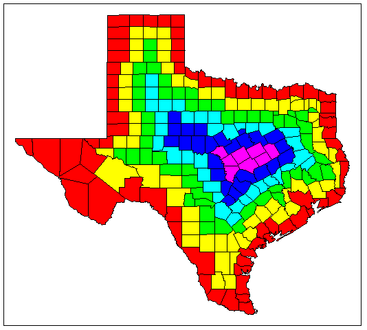
I’ve defined Texas as possessing five layers of borderlocking because it contains a core of counties nestled within five concentric county layers within its state boundaries. Eight counties form that inner core across a swath of east-central Texas. Residents of that area must travel through five other counties at a minimum if they want to leave Texas. No resident of any other state has to travel a minimal path of this magnitude if they want to hit their homestate border. Texas is downright impressive considering that the United States has only 17 layers of borderlocking for its international boundaries.
The Inner Core
People living within the inner core don’t exist in some isolated wilderness by any means. Killeen and Waco both fall within the perimeter of this layer. The next time you see a news story about a U.S. military operation involving soldiers from Fort Hood, you will also know that those troops are among the most borderlocked inhabitants of Texas. I’m sure that fact will dazzle and amaze your friends and coworkers at the next Happy Hour. The total population comes out to something like three quarters of a million people living in the counties of Bell, Burnet, Coryell, Falls, Lampasas, Limestone, McLennan, and Mills. That’s quite a lot.
Plateau vs. Prairie
Like Texas, the inner core exists at a crossroads between differing geographies. The maps I’ve consulted seem to vary all over the place especially when they’re skewed towards geology versus vegetation. Roughly the western portion falls within the Edwards Plateau and the eastern within the Blackland Prairie.
The Edwards Plateau is a hilly limestone formation with lots of caves and springs. It’s not overly suitable to farming but it’s great for grazing livestock, primarily cattle. The Texas Hill Country is generally considered to be within the Edwards Plateau if that helps characterize it.
Bison once roamed the Blackland Prairie and wildfires raged across it periodically. Those fires were a vital part of the environment, remove woody plants and allowing tallgrass prairies to dominate the range. Large tracts of original prairie fell to the plow beginning in the latter 19th Century. That’s because cotton grew particularly well in the rich black soils found there. It is estimated that 99.9% of Blackland Prairie tallgrass has been lost. Only two small stands of original Tallgrass Prairie remain, both of them outside and southeast of the borderlocked core.
The optimally borderlocked core sounds like an interesting place to visit even beyond it’s status as a genuine geo-oddity.
Leave a Reply