
Is Borderlock (-ed) (-ing) even a word? I don’t think so. “Landlocked” is a perfectly fine word but it doesn’t quite cover the situation I’m attempting to describe. I noticed a query that arrived recently on Twelve Mile Circle from a user of a well-known search engine. It piqued my curiosity.
I’ve started many an article with a lede just like that. Truthfully, this is a great idea generator and an occasional benefit that comes with checking the access logs each day. Sometimes the fishing net drags-in an unexpected haul that results in an article. This time the search term seemed rather innocuous. However, it entertained me for several hours: “how many Maryland counties border another state?”
I know, I like strange things. It’s a gift.
Examining Maryland
I though first, well almost all of them since Maryland is small, skinny and irregularly shaped. However, what does “border another state” actually mean? Certainly counties sharing a land border with the state boundary count towards that tally. I suppose someone could also make a case for waterborne boundaries.
In this instance Maryland owns the Potomac River up the the shoreline of Virginia. Thus all Maryland counties except Anne Arundel, Calvert, Talbot and the the City of Baltimore (independent and considered a “county equivalent” — but not to be confused with the County of Baltimore proper).
Then I started having some fun with it. I began to wonder, what would happen if I expanded the definition to included counties with direct access to the sea. Thus, are there any truly “borderlocked” counties within Maryland? Those would include counties that neither touch a state border nor have a reasonable outlet to the sea. They would have to be completely enclosed within the interior of the state. Trapped.
Make that slight change to the definition, note that Baltimore City, Calvert and Talbot all have direct access to the sea, and only Howard County remains totally borderlocked.
I Took It A Step Further
How many levels of borderlocking exist for each of the fifty states? These include instances of one or more borderlocked counties hemmed in by a ring of borderlocked counties, then surrounded by another ring of borderlocked counties, and so on. It’s kind-of like a double landlocked country but a little different. Maryland, as we just observed, demonstrates ONE level of borderlocking. Travel from borderlocked Howard County to any of its neighboring counties and one will find direct access to the state border either by land or by sea.
In homage to my obsessive-compulsive side, this is what it looked like for all fifty states.
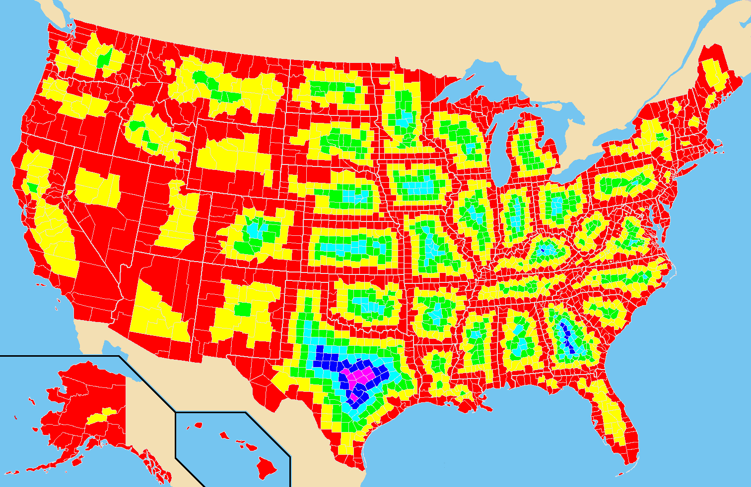
About the Map
Indeed, I colored each of the 3,000+ counties in the United States on this map. Now I know the level of borderlocking for each state. Well, in my defense, it didn’t take very long. I could have been excessively precise but I guessed liberally when it was close. I am sure it includes errors but I have a life so I didn’t spend hours obsessing over exact precision. And I just spotted one now but I’m too lazy to go back and fix it.
Also I discovered that this method of mapping was fairly self-healing. An error might impact the coloring of one or two counties. Nonetheless, it usually didn’t change the formation of subsequent ring(s).
By the way, feel free to right-click the image and open open it up in another tab if you want to see it in greater detail. I shrunk it down to fit within the confines of the blog template. Even so your browser already read the full-sized image. It still lurks behind the scenes. I simply adjusted the width and height of the image tag in the underlying HTML code.
Superlatives
The various states fall into ranges. There are some states like Connecticut (sorry, CTMQ), Rhode Island and Delaware that have ZERO borderlocking. There, every county straddles the state border, either by land or by sea.
Great extremities exist in Georgia and Kentucky with four levels of borderlocking. Then I found the Grand Champion only in Texas with an astounding FIVE levels of borderlocking. That’s right, there are select people in Texas who need to cross through a minimum of five counties before hitting the state border.
Taking it National
Apparently that wasn’t enough for me. I had to discover the most borderlocked counties in the United States overall rather than by individual state. So I produced the following map.
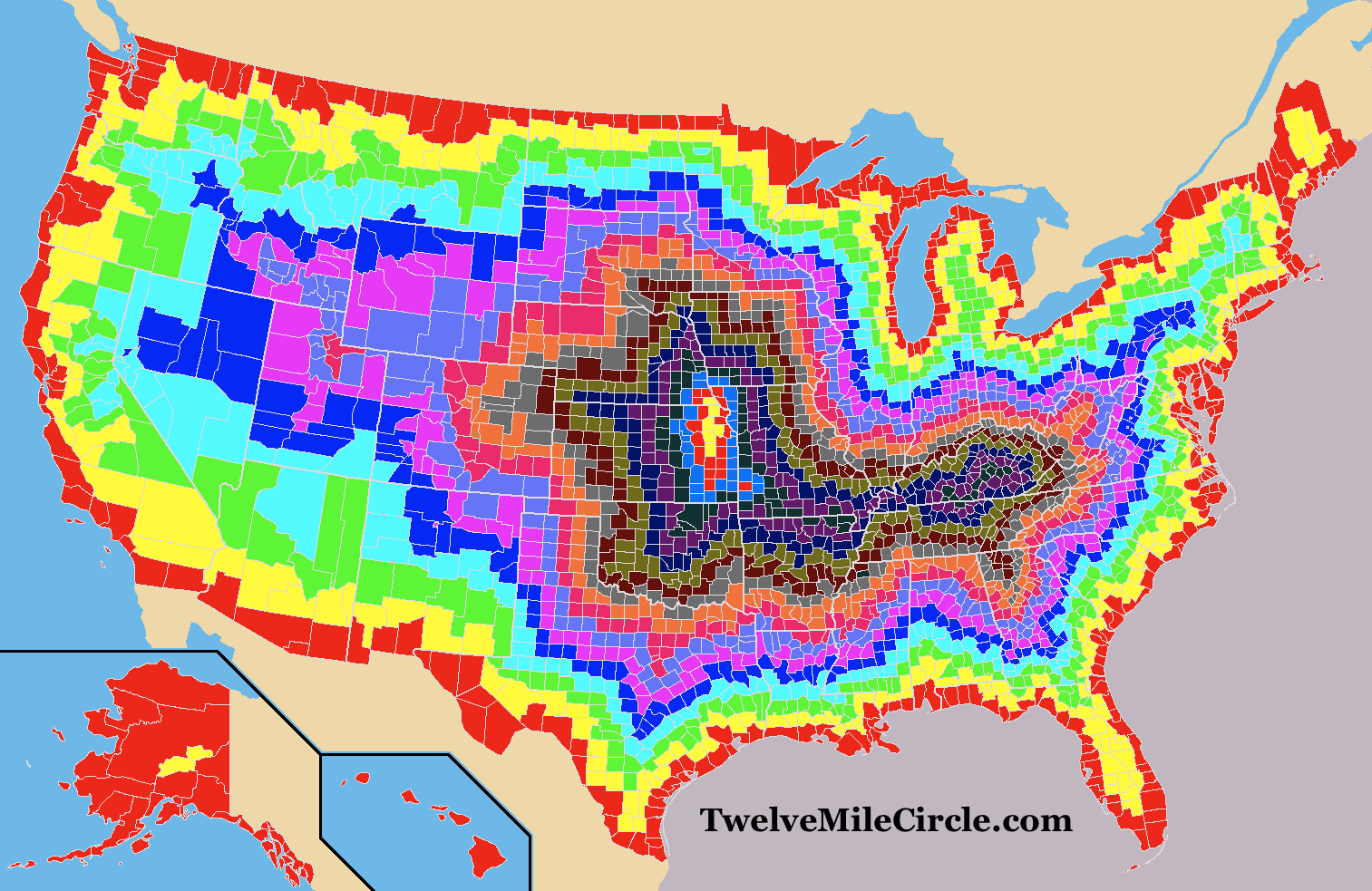
Before I looked at the resulting data I have to say that I appreciated the map first on an artistic scale. It reminded me of the inside of a geode; morphing and changing as it drew closer towards the center. I found myself staring at the image on its own terms as much as I pondered the geographic implications. It’s kind-of mesmerizing.
What this says, assuming I’ve drawn and counted this correctly, is that there are only SEVENTEEN layers of borderlocking for the collective counties of the United States. Think about it. Nobody, ever, is more than seventeen counties away from an international border or the sea. That extreme definition applies only to a scattering of counties in eastern Kansas plus one lonely county in far southeastern Nebraska. Most people are considerably closer.
But Is It Practical?
A traveler could and probably would take a more circuitous route involving many more counties unless he wanted to undertake this trip on foot. However, in theory at least, he could reach a land or sea border by traversing seventeen counties or fewer depending upon his starting point. Can someone do it by automobile? I’m not sure. The path would need to avoid places where the layers meet at a single point. There are lots of square counties connected on a diagonal.
I think I see a possibility heading from eastern Kansas towards the general direction of Lake Michigan. Maybe I’ll save that puzzle for a future article if people seem interested. Maybe someday you’ll earn bragging rights by being the first person to drive it!
This isn’t what I expected to find at all. Thank you random visitor who had no idea that I’d latch onto it somehow and take it down this path.
Leave a Reply