Four Corners

The U.S. Four Corners Monument. Photo by howderfamily.com; (CC BY-NC-SA 2.0)
Four Corners – Summer 1992

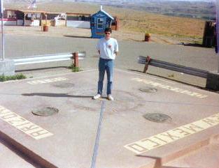
Four Corners is a unique spot in the United States. It’s the only U.S. location where four states join together with a common boundary – a quadripoint. Thus, a visitor can touch Arizona, Colorado, New Mexico and Arizona simultaneously.

Maps of the area show this situation clearly and anyone can get there by automobile with only a short detour. Thus it may be the most famous and commercialized piece of “strange geography” in the United States.

The Navajo Nation maintains the site and charges a nominal admission fee. Also, enterprising entrepreneurs sell a variety of Native American crafts at the site. They’ve created a ring of craft tables along the periphery of the monument.

Absolutely no logical reason exists to commemorate this barren patch of desert except for two artificially designated lines that happen to cross there.

… And yet I’m curiously drawn to it.


Updates

A couple of notes added after the original publication of this entry:

  • I am aware of the controversy concerning the placement of the Four Corners supposedly at the “wrong” spot and the quick rebuttals of that claim. Regardless of the claims and counterclaims, surveyors established this spot and the government recognizes this as the point where four states intersect.
  • There is also a 4-Corners in Canada, featured previously.

See also: my visit to the 4-Corners region in 2017.


Posted

in

, ,

by

Comments

2 responses to “Four Corners”

  1. Greg Avatar
    Greg

    The Google map shows the UT/CO border doing a clear jog just north of Four Corners. Is that accurate (I assume it is), and do you know the history of it?

    1. Twelve Mile Circle Avatar

      Good catch, Greg. The Utah – Colorado border is a funny thing. It looks like a straight line on a larger map, and it’s supposed to be a straight line, but it actually has a number of kinks in it. You can see more information on a previous article, "It’s not a Rectangle." The short answer is that it was difficult to survey a completely straight line through rough terrain using 19th Century surveying techniques. You’ll find a number of these small errors on many of the "straight" borders of the Western states. Actually the surveyors did a remarkable job, all things considered.

Leave a Reply

Your email address will not be published. Required fields are marked *

Latest Comments

  1. Technically it’s not always correct to say EST/CST, etc…. but just an indication that I’m changing time zone is enough,…

  2. In general, I wonder why navigating from the Atlantic Ocean to the Black Sea doesn’t count as inland navigation.

  3. Re: East/West Carroll parishes, you’re close, but the real reason for the split was more political than demographic or cultural.…