
There are 36 Counties in Oregon – “The Beaver State“
Also be sure to see my United States County Counting Page for the rest of the states.
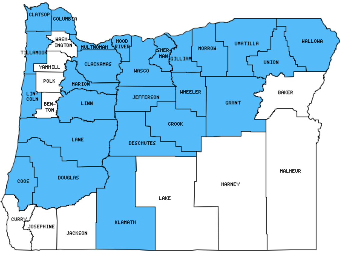
I have visited 23 Counties = 63.9% of Counties in Oregon
Counties visited are colored-in; counties still needing to be visited are blank. Map created using Mob Rule.
Twelve Mile Circle Articles Featuring Places in Oregon
Markers designate the Oregon locations featured in Twelve Mile Circle articles.
Counties in Oregon
Below are the 36 counties in Oregon. Although infrequent, counties sometimes do change so please let me know if any of this information is out of date and I will update it. Those counties that I have visited are highlighted in Red. Readers can also link to any articles manually in this section if the map isn’t working.
- Baker: Almost Halfway; Negligible Population
- Benton: Checkerboarding
- Clackamas: Boring, Dull and Bland; I Before E Like in Milwaukie; Zig Zag; Just as Enigmatic; Switching Sides
- Clatsop: Astoria Column; Ferry Wahkiakum; Particularly Possessive
- Columbia
- Coos: Oregon Dunes National Recreation Area; Bank Brewing Company
- Crook
- Curry
- Deschutes: Drake Park; Mount Bachelor Resort; Big Eddy; High Desert Museum; The Bend Ale Trail (10 Barrel Brewing Co., Bend Brewing Co., Boneyard Beer, Brew Wërks Brewing, Cascade Lakes Brewing Co., Deschutes Brewery, GoodLife Brewing Company, Old Saint Francis Brewpub, Silver Moon Brewing, Three Creeks Brewing), Big Obsidian Flow; Sunriver Brewing Company
- Douglas: Just as Enigmatic; Umpqua River Lighthouse, Reedsport
- Gilliam: John Day’s Day; Another Day with John Day
- Grant: Negligible Population; John Day’s Day; Another Day with John Day
- Harney: Largest county in Oregon (10,134 square miles).
- Hood River: Mount Hood Vista; Full Sail Brewing Co. (Hood River)
- Jackson
- Jefferson: Pump Your Own Gas
- Josephine: Where’s Waldo?
- Klamath: Deepest Lakes; Crater Lake; Cleetwood Trail
- Lake: Christmas Lake
- Lane: Named for Captain Cook; Most Frequent Communities; Eugene City Brewery; High Street Brewery Café; Oregon Fields Brewing Co.; Steelhead Brewery & Café; Wild Duck Brewery
- Lincoln: The “D” River (world’s shortest?); Rogue Ale Public House, Yaquina Head Lighthouse
- Linn: Sweet Home, uh, Oregon
- Malheur: Time Zone Anomaly; Time Zone Limits; Potomac in Oregon; Surrounded in Time
- Marion
- Morrow
- Multnomah: Smallest county in Oregon (435 square miles) and largest county population in Oregon (660,486 people in 2000 Census); Iconic Views; Grotian Traditions, Thalwegs and Winner Take All; Geo-Oddities of Portland, Oregon; Back to the Lines; My Smallest Park; 132 and Bush; Bad Boys Revisited; Multnomah Falls; McMenamins’ Edgefield Brewery; Full Sail Brewing Co. (Portland); Lucky Labrador Brewing Company; Rock Bottom Brewery
- Polk
- Sherman: John Day’s Day; Another Day with John Day
- Tillamook: Cape Meares Lighthouse; Pelican Pub & Brewery
- Umatilla: Extreme Reservations
- Union
- Wallowa
- Wasco: The Dalles; Bought the Town
- Washington: Hillsboro Hops; Hawaii on the Mainland
- Wheeler: Smallest county population in Oregon (1,547 people in 2000 Census); Painted Hills; Shoe Tree
- Yamhill
Quick Facts About Oregon
- Location: Pacific Northwest United States. See map above.
- Size(1): 95,988 square miles. Oregon is the 10th largest state. The next larger state is Wyoming and the next smaller state is Idaho.
- Population(2): 4,190,713 people. Oregon is the 27th most populous state. The next more populous state is Kentucky and the next less populous state is Oklahoma.
- Population Density: 43.7 people per square mile. Oregon is the 38th most densely populated state. The next more densely populated state is Colorado and the next less densely populated state is Maine.
- Bordering States: Oregon shares a border with 4 states: Washington; California; Nevada and Idaho.
- Admission to the Union: February 14, 1859. Oregon was the 33rd state admitted to the Union, after Minnesota and before Kansas.
- Capital: Salem.
- Highest Point: 1,1239 feet at Mount Hood. See SummitPost’s Mount Hood page.
- Lowest Point: Sea Level at the Pacific Ocean.
- Government website: Oregon.gov Home Page.
- Official Tourism website: Travel Oregon.
- Still not enough? See Wikipedia’s Oregon page.
Sources:
(1) Wikipedia: List of U.S. states and territories by area. Land area only.
(2) Wikipedia: List of states and territories of the United States by population. Estimated population on July 1, 2019.
Leave a Reply