
Checkerboarding has nothing to do with the game of checkers other than bearing a striking resemblance to its playing surface. Nor is it some awful new interrogation technique invented to pry information from suspects under duress.
It is this.
I discovered the anomaly on Google Maps in Oregon awhile ago while discussing Latitude Longitude Sequences and dismissed it as a probable error. Not so fast, replied a couple of contributors in the article comments. Reader Craig observed that the checkerboard phenomenon has been superimposed upon the physical terrain and reader Page noted correctly that it originated as a result of 19th Century railroading.
The Railroads
Simply explained, the government was rich in land but poor in cash, hoping to construct a transcontinental railroad while devoting significant resources to fighting a Civil War already underway. That railroad would finally stretch across the nation in 1869 when the Union Pacific met the Central Pacific at Utah’s Promontory Summit (my visit).
The government dangled a carrot in front of the railroads to keep construction going. It offering several miles of land on either side of the tracks (the amount varied over time), replicating a process that had been used further east with some success. However, it wouldn’t be a single, solid ribbon of land overlaying the tracks. It was a patchwork of every-other block of one square mile.

Notice the resulting pattern, akin to a checkerboard, and thus the name.
Why would a government create such an odd situation? Because It felt that railroads could sell the land to finance construction and underwrite future operations and maintenance. Undoubtedly the value of the land would rise over time because of its proximity to emerging rail lines. Towns would form at transportation hubs. Farms would sprout around them. Everyone would be happy and prosper. The government wanted a piece of the windfall so it retained half of the squares, intending to sell its parcels as settlers moved west along the lines.
The Results
It didn’t turn out quite as expected. The land wasn’t all that great, settlers didn’t have much money and many of the parcels remained unsold. The government eventually doubled the land grants just to keep the railroads motivated. This resulted in huge 40-mile wide (64 km) checkerboard gashes crisscrossing the nation.
The railroads sold much of their land over time, often to timber companies wherever routes snaked through the western mountains. The government also sold parcels when it could find a willing buyer, gave a bunch away to homesteaders for free, and allotted other portions to Indian reservations. Much of the rest of the government’s share remained public space eventually falling within the jurisdiction of the Bureau of Land Management.
Legacy
Amazingly, these railroad incentives created more than a century and a half ago continue to be visible upon the terrain today. That’s what I’d stumbled across accidentally in the earlier article.
National Forests
Observe the boundaries within the checkerboard patterns in the Siuslaw National Forest in satellite view. Feel free to toggle back-and-forth between map and satellite and notice how they match.
I found an even better example. Notice the stark difference between the protected and logged areas:
This instance occurs near Snoqualmie Pass in Washington. The square, characteristically one mile on each side, has been clear-cut logged. The lush green area surrounding it is National Forest. It’s that stark. Squares unsold by the government were protected. The others owned by railroads were either leased or sold to logging companies and were harvested.
Native Americans
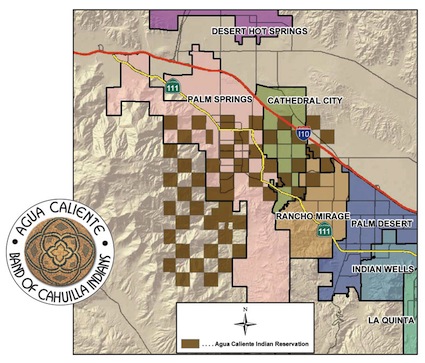
Native Americans got a pretty raw deal too. Imagine a reservation where every-other-parcel was owned by an outsider. The Agua Caliente Band of Cahuilla Indians were one leading example of a checkerboarded tribal nation:
“All even-numbered sections and all unsurveyed portions of Township 4 South, Ranges 4 and 5 East, and Township 5 South, Range 4 East, San Bernardino Meridian, were added to the Reservation, except Sections 16 and 36 and any tract the title to which had passed out of the U. S. Government. The Government had previously given the odd-numbered sections to the railroad in the early 1870s as an incentive to build a cross-country rail line… On a combined basis, the Tribe and its members currently represent Palm Springs’ largest single landowner.”
At least it may have work out for them… eventually. I looked at maps of Palm Springs and noticed that many of the golf courses and resorts there are located on Agua Caliente property. I imagine they’d rather have a contiguous reservation along with that, though.
Environmentalists and Hunters
Environmentalists don’t much like checkerboarding. It makes it very difficult to protect swaths of sensitive land since people who own private parcels are guaranteed access to them across the public spaces.
Hunters don’t much like the situation either. It causes lots of confusion as they try to remain on BLM parcels and wrestle with whether it’s legal to jump from corner-to-corner, staying on BLM land while avoiding private land. Apparently corner hopping is not allowed, a situation that seems to favor those who own private parcels (with guaranteed access) over those who wish to use public land (and cannot corner hop).
An incentive program failed in the 19th Century and the nation continues to deal with the mess.
Totally Unrelated
A tip of the keyboard to the Basement Geographer who is taking a (hopefully brief) break from writing. The Basement Geographer is one of my personal favorites and I never miss an article. Thank you for all of your great work over the years, Kyle.
Leave a Reply