
There are 56 Counties in Montana – “Big Sky Country“
Also be sure to see my United States County Counting Page for the rest of the states.
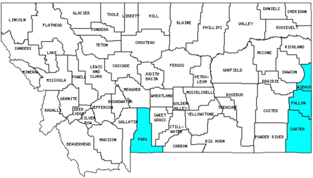
I have visited 4 Counties = 7.1% of Counties in Montana
Counties visited are colored-in; counties still needing to be visited are blank. Map created using Mob Rule.
Twelve Mile Circle Articles Featuring Places in Montana
Markers designate the Montana locations featured in Twelve Mile Circle articles.
Counties in Montana
Below are the 56 counties in Montana. Although infrequent, counties sometimes do change so please let me know if any of this information is out of date and I will update it. Those counties that I have visited are highlighted in Red. Readers can also link to any articles manually in this section if the map isn’t working.
- Beaverhead: Largest county in Montana (5,542 square miles).
- Big Horn: Where Custer Fell; Adjacent Counties, Same Name, Different States
- Blaine: Throw the Dart
- Broadwater
- Carbon: Boomerang
- Carter: Big Sky
- Cascade: The Roe River (world’s shortest?)
- Chouteau
- Custer: Joe Montana; King of Portmanteau
- Daniels: Least Visited U.S. Counties; What Crosses an Airport Runway?
- Dawson: Room to Grow
- Deer Lodge
- Fallon
- Fergus
- Flathead: Hydrological Apex of North America; Sundog
- Gallatin
- Garfield: Last Presidential Counties
- Glacier: Hydrological Apex of North America
- Golden Valley
- Granite
- Hill
- Jefferson
- Judith Basin
- Lake
- Lewis and Clark: Rogers Pass
- Liberty: Infrequent Crossings
- Lincoln: Ted’s Last Stand
- Madison: Earthquake Lake; Virginia Silver and Gold
- McCone: Going in Circles; Beery Places
- Meagher
- Mineral: King of Portmanteau; Digging for Minerals
- Missoula: Streets Named After…
- Musselshell
- Park: Adjacent Counties, Same Name, Different States
- Petroleum: Smallest county population in Montana (493 people in 2000 Census); Not Quite Obscure Enough.
- Phillips
- Pondera
- Powder River
- Powell
- Prairie
- Ravalli
- Richland
- Roosevelt: Last Presidential Counties
- Rosebud: Colstrip
- Sanders
- Sheridan: Extreme Differences of Extremes; County Divided
- Silver Bow: Smallest county in Montana (718 square miles); Ghost Signs
- Stillwater
- Sweet Grass
- Teton
- Toole: What Crosses an Airport Runway?
- Treasure
- Valley: No Names and Nameless; Remote Chinese Restaurants
- Wheatland
- Wibaux
- Yellowstone: Largest county population in Montana (129,352 people in 2000 Census).
Quick Facts About Montana
- Location: Mountain West United States. See map above.
- Size(1): 145,546 square miles. Montana is the 4th largest state. The next larger state is California and the next smaller state is New Mexico.
- Population(2): 1.074,406 people. Montana is the 43rd most populous state. The next more populous state is Maine and the next less populous state is Rhode Island.
- Population Density: 7.4 people per square mile. Montana is the 48th most densely populated state. The next more densely populated state is North Dakota and the next less densely populated state is Wyoming.
- Bordering States: Montana shares a border with 4 states: Idaho, Wyoming, South Dakota and North Dakota.
- Admission to the Union: November 8, 1889. Montana was the 41st state admitted to the Union, after South Dakota and before Washington.
- Capital: Helena.
- Highest Point: 12,799 feet at Granite Peak. See SummitPost’s Granite Peak page.
- Lowest Point: 1,800 feet at the Kootenai River, Lincoln County.
- Government website: mt.gov – Montana’s Official State Website.
- Official Tourism website: Montana – Big Sky Country.
- Still not enough? See Wikipedia’s Montana page.
Sources:
(1) Wikipedia: List of U.S. states and territories by area. Land area only.
(2) Wikipedia: List of states and territories of the United States by population. Estimated population on July 1, 2019.
Leave a Reply