
There weren’t a lot of people on the Northern Plains and their settlements appeared only sporadically. Out there amongst the expansive void a place of a thousand residents qualified as a city and drivers might not see another one for an hour. I wondered, where did people even buy their groceries? That didn’t mean the space was lacking in interests, though. The terrain, so alien from my normal experiences became the prime attraction.
Mount Rushmore

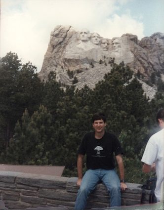
I treated Mt. Rushmore (map) as a do-over. Me and some friends rented a recreational vehicle and drove around the United States visiting many of its famous national parks long ago in 1992. I recounted a small portion of that journey in Crossing South Dakota on Interstate 90 on my travel pages. It included a stop at Mt. Rushmore where I recalled feeling underwhelmed. The massive sculpture seemed so small and distant, a disappointment. And couldn’t they have cleared the debris pile? Would I still feel this way, an older and hopefully slightly wiser version of myself almost a quarter century later?
At least I brought a better camera. This was the best we could manage with a cheap Kodak Instamatic point-and-shoot film camera during the pre-digital days of my previous effort:
I’d downplayed the experience so much that I created low expectations for my wife who’d never seen the sculpture. She felt we had to go there despite my minimal enthusiasm because she couldn’t conceive of driving directly through the Black Hills without stopping at Mt. Rushmore. It was one of those sites, she noted, that all Americans needed to experience at least once in their lifetimes. I grumbled a bit and muttered that she might be disappointed although I didn’t disagree with her logic.
We drove up to the park, still mobbed with tourists even after Labor Day, and walked towards the viewing deck as we pushed past disgorging busloads. I didn’t have anything better to do I figured, while I tried to clear away my earlier impressions. Yes, it was better than my past experience although the entire notion of defacing a mountain in the middle of nowhere still seemed weird. My wife thought it was incredible, I’m guessing because the genuine version eclipsed the negative vibe I’d so carefully crafted ahead of time.
Crazy Horse

Several loyal Twelve Mile Circle readers suggested that I should visit the Crazy Horse Memorial (map), just a short hop from Rushmore. Sure, why not. People seemed to enjoy carving outcrops with giant sculptures in the Black Hills. I might as well take a peek at their handiwork.
Crazy Horse’s emerging presence on Thunderhead Mountain served as a fitting counterweight to the image of US presidents appearing on Mt. Rushmore. It represented the point of view of the original inhabitants, the Oglala Lakota of the Great Sioux Nation. Many of them resented everything Mt. Rushmore presented, the defiling of a sacred mountain with gigantic sculptures of their oppressors. The insult couldn’t be removed although they could commission an even bigger and better sculpture of their war leader Crazy Horse (~1840-1877) who resisted territorial encroachment and died battling US troops. It was more sensible than carving an oversized middle finger although I wouldn’t blamed them if they’d done that instead.
Work began in 1948. Much remains undone. The current sculptors dedicated Crazy Horse’s face in 1998 and moved on to the horse. When finished, Crazy Horse will sit atop his steed with arm pointed forward. The sculpture will stand 563 feet (172 m) high and 641 feet (195 m) wide, possibly the largest in the world. They have not accepted any Federal funding in order to maintain independence. The project continues to move slowly as money allows. Crazy Horse won’t emerge completely during our lifetimes and maybe not even in the lifetimes of our children at the current pace.
Theodore Roosevelt National Park

I mentioned earlier that I took a detour to Theodore Roosevelt National Park (map) mostly as a pretext to capture a couple of extra counties I’d never visited before. What a lucky decision. The park was practically empty, an otherworldly corner of North Dakota’s badlands. We hit the southern unit based in the town of Medora. I didn’t have much to say about Medora because it seemed like they rolled-up the sidewalks after Labor Day. I had a tough time even finding a sandwich for lunch. The place looked nice enough in a faux old-timey “western” kind of way although it resembled a ghost town in mid-September.
We drove into the park and took the 36-mile (58km) Scenic Loop Drive. A word of caution, when signs posted a 25 mph speed limit they meant every word of it even along the completely empty back section. Thank you Mr. Park Ranger for, ahem, letting me off with a verbal warning when I truly deserved a ticket. Much obliged.
The loop offered several scenic overlooks, some right by the road and others needing short simple hikes. My favorite was called the Wild Canyon Trail and it led to a bluff high above the Little Missouri River. The park was noted for its wildlife although we didn’t experience much of that other than a few prairie dogs and a small herd of wild horses. We didn’t see the famed bison although several hundred roamed freely there. It became a running joke for much of the rest of the trip until days later when our luck improved in the Black Hills. Instead we were left with the incredible scenery which more than held its own ground.
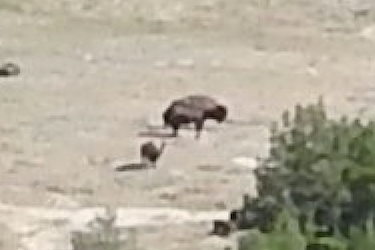
Ironically, as I leafed through photographs upon our return, I noticed a few black dots and zoomed way in. They were bison. The bison were always present during our visit to Theodore Roosevelt National Park and ready to be discovered if we’d only looked a little harder.
Devils Tower

This was my second trip to Devils Tower (map), seen previously on that same epic journey as my original visit to Mt. Rushmore. In contrast I recalled being awed by Devils Tower, a thousand foot (300 m) remnant of an ancient volcanic plug. Once again I walked around its base, neck craned skyward in appreciation of the spectacle and searching for climbers working their way to the top. We didn’t stay overnight so I couldn’t confirm if the campground still screened “Close Encounters of the Third Kind” every evening or not. I bet they did.
Big Sky

Most of the terrain lacked the dramatic flair of badlands, mountains and extinct volcanoes. There was a vast emptiness all the way to the horizon, hour after hour. I never got bored. The loneliness fascinated me. Once I drove a hundred miles (160 km) from the Montana border (map) to the town of Baker mid-afternoon with perfect weather. I never saw another car in my lane ahead of me or behind me the entire time. Maybe a half dozen cars drove past in the opposite direction. That was some serious Big Sky.
Center of the Nation articles:
See Also: The Complete Photo Album on Flickr
Leave a Reply