
I’m going to take a little bit of a departure from the usual Twelve Mile Circle travelogue format. I’ll actually suggest a couple of simple one-day itineraries. They mirror actual trips starting from our home base for the week in Asheville, North Carolina. Readers should feel free to customize them at their discretion. Admittedly, they do tend to reflect my peculiar interests and geo-geek desires. Even so, I’d love to hear if anyone actually follows the path.
The first loop involved a lovely jaunt on and near a segment of the famous Blue Ridge Parkway northeast of Asheville. The parkway included numerous mountaintop pull-offs where one could enjoy magnificent views in addition to the sites I’ve highlighted. Those went without saying so take a scenic break whenever it feels right. You’ll want to savor this route slowly.
We chose to drive in a counterclockwise or anticlockwise direction. Even so, it could be adapted to a clockwise route or even a pure out-and-back without much effort. That depends on time constraints and sightseeing preferences.
Linville Caverns

I love caves and my kids love them too, maybe even more than I love them. We’ve taken tours of several caves during our wanderings to places like Idaho, Utah, Texas, Oregon, Kentucky and even Ireland. Naturally, Linville Caverns — which bills itself as North Carolina’s “Only Show Cavern” (and I have no way to verify that so I’ll take it at face value) — would have to be on our itinerary seeing how it fell directly along our desired path (map).
Formations
We found several interesting formations worth viewing although frankly I’ve seen more spectacular caverns elsewhere. The guides also went through the obligatory “turn out the lights and show everyone how dark it was” demonstration so it seemed to follow the usual script. The cave served as a nice enough diversion and the tour took only about a half-hour. It didn’t gobble up too much of the day. The passageways also offered a cool, refreshing 53° Fahrenheit (12° C) on a day when the outdoor temperature reached above 90° (32° C) with matching humidity. That almost made it worth the price of admission right there. I’d go back if I drove through the area again.
Bats
The US Fish & Wildlife Service and the North Carolina Wildlife Commission recently discovered several bats in Linville Caverns with White-Nose Syndrome. That meant that anything I brought into the cave will never be allowed inside another cave. Thus I used my mobile phone camera instead of my nice one, and the lower-quality photos reflected that decision.
Famous Louise’s Rock House Restaurant

The 12MC audience might wonder why I visited a restaurant other than a brewpub given my past history of articles. Famous Louise’s Rock House Restaurant deserved an exception. I featured it on these very pages back in 2009. At the time I explained, “This is now included on my extensive list of places I need to visit someday.” Well, someday finally arrived and I did indeed visit. Famous Louise’s became famous because it sat atop a county tripoint. One could walk between Avery, Burke and McDowell Counties, or stand in all three at the same time if one desired, all within the walls of a single restaurant (map).
Try the Homemade Baked Apples
Famous Louise’s got mixed reviews on various restaurant and travel rating websites. We arrived for lunch on the early end, around 11:30, and most tables sat empty. The opposite was the case when we left so perhaps that made the difference. For that reason I’d recommend arriving a little early for mealtime. We experienced great service and even got a wonderful tip about the homemade baked apples. The food seemed decent and a solid value. Plus we had the whole county tripoint thing going on there, with each county line labeled on individual signs hanging from the ceiling. I love it when I can visit places in person that I’ve mentioned on 12MC beforehand.
About that Geographic Claim
Geo-geeks sometimes debate whether the tripoint actually falls within the restaurant or not. Maps I consulted insinuated that the true tripoint might be found just outside along a gravel road. I got as close as I could get to take a photo and cover my bases, while respecting the no trespassing sign placed there. Perhaps I wasn’t the first geo-geek trying to find the true magic spot. Who am I kidding? Nobody else has ever done that here.
Linville Falls

Linville Caverns, Famous Louise’s and Linville Falls could all be visited in one convenient cluster. The falls became one of those iconic features along this stretch of the Blue Ridge that really shouldn’t be missed (map). Access required a fifteen minute hike from the visitor center although nothing too strenuous. Various other hiking options also existed depending on whether one wished to view the falls from above or below. We didn’t have time to do both so we selected the first option. It was hard to tell if the view would have been better from ground level. That provides an excuse to come back again someday.
Mount Mitchell
I’m not a traditional state highpointer. I don’t have a desire to highpoint all 50 states because, well, I’m lazy. I don’t ever expect to get to the top of Denali in Alaska. Nonetheless I hate to leave an open list, so I decided long ago to cherry-pick the easy ones and ignore the rest.
The only highpoint where I expended any significant effort to get there happened in Connecticut at Mount Frissell. That occurred only because Steve from Connecticut Museum Quest shamed me into it. Otherwise I like the kind where I drive all the way up to the top and claim the honor simply by walking a few feet, like New Jersey. Better yet, how about the little bump-out by the side of the road in Delaware? Or the subway ride to the District of Columbia highpoint even if not actually a state? Those all fit my style better.
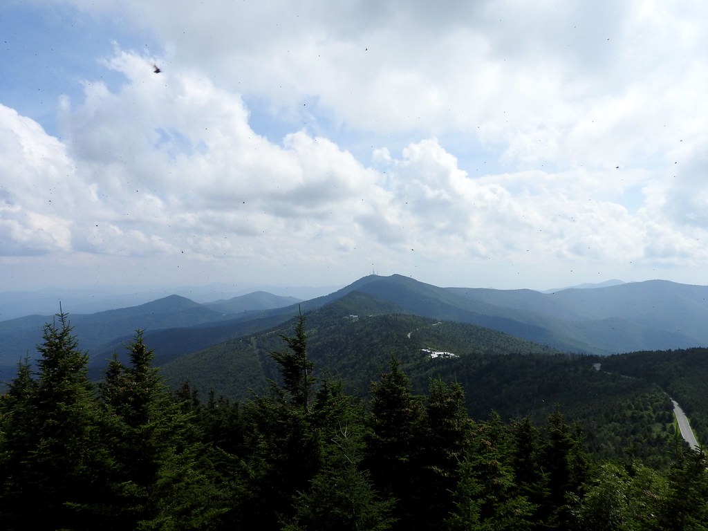
A Thankfully Easy Summit
The North Carolina highpoint fit perfectly within that same low-effort mountaineering philosophy. It differed, however, because it was a “real” mountain. Mount Mitchell wasn’t a poseur, rather it was the highest mountain east of the Mississippi River at 6,684 feet (2,037 metres) (map).
The good people of North Carolina had the courtesy to pave a road almost all the way to the top of the summit, bless their hearts. From the final base camp to the top, oh it took maybe a ten minute walk.
Evil Weevils
There was one single hardship, and readers can sense it in the form of little black specs on the photograph — the huge swarms of insects at the summit. Your screen doesn’t need to be cleaned. See those dots? BUGS!
Loyal 12MC reader and Twitter follower @thegreatzo diagnosed this as a particularly large outbreak of the Yellow Poplar Weevil. They were harmless to humans although nobody really likes the feeling of hundreds of insects crawling on them. Lots of people on the mountain thought they were ticks so it was pretty amusing to watch them freak out.
I’ll talk about a second day-trip loop in the next article.
Leave a Reply