
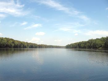
Potomac River between Montgomery Co., MD and Loudoun Co., VA (September 2007)
We arrived at the White’s Ferry landing west of Poolesville Maryland on our journey towards Virginia’s wine country and took our place in queue. A small flat-bottomed barge carried weekend explorers across the river on this sunny Saturday afternoon. The ferryboat “Jubal A. Early,” the last of its kind along the length of the Potomac, followed its guiding cable forward to the opposite shore.
Origin
White’s Ferry traced its origins to the early 1800’s and gained its current name sometime after being purchased in 1871 by Elijah V. White, a prosperous businessman living on the Virginia side. He maintained a vital crossing for the residents of western Montgomery County, MD and northeastern Loudoun County, VA. This also allowed 19th Century Virginia farmers to connect with the Chesapeake and Ohio (“C&O”) canal so they could get their crops to market faster. This junction intersected the C&O at mile 35.5.
Jubal Early
Elijah White served as a Confederate army officer in the Civil War under General Jubal Anderson Early. He duly named the ferryboat in honor of his former commander. Several subsequent owners and vessels continued the tradition, and the latest Jubal A. Early still connects the two riverbanks.
During the war, Gen. Early battled ferociously as part of Robert E. Lee’s renowned Army of Northern Virginia. Gen. Early attempted to invade Washington in 1864 to draw Union troops away from Petersburg. He penetrated all the way into the District of Columbia before being repulsed at Fort Stevens, one of a series of perimeter forts built to defend the Nation’s capital from attack.
Gen. Early became a vocal proponent of the Lost Cause after the war and, and even though pardoned, never took an oath of loyalty. It is probably worth remembering that sections of Maryland remained within the Union essentially by occupation, so it shouldn’t seem too unusual that residents on both sides of the river accepted a ferryboat named after an unrepentant secessionist general.
Landing on the Maryland Side

It took a couple of cycles before we arrived at the front of the line and drove aboard. The brief wait gave us a few minutes to wander around the Maryland landing. This rural locale attracted lots of people, not just for the ferry ride but as a recreational destination, with each aspect converted into an entrepreneurial opportunity.
The ferry made good money that day at 24 cars per crossing, $4.00 per vehicle and a trip about every five minutes, but that was only the beginning. We noticed a slew of related ventures spun-off by the current operators. A general store sold snacks and beverages. Rowboats and canoes rented out by the hour or day. A boat launch provided river access to larger watercraft. A picnic area with grills was available as was a larger pavilion for group events. On the day we visited, people fished, paddled tranquil waters or relaxed under the shade trees, and a church congregation waded into the river to baptize new members.
Controversy
We crossed the river smoothly, barely moving. Only the engine’s diesel drone broke the calm. It was hard to imagine that such a placid stretch of river plays a crucial role in a raging transportation controversy.
The American Legion Bridge (known to old-timers as the Cabin John Bridge) leads the western flank of Interstate 495, the famous Washington Beltway, across the Potomac River. No other bridge exists any further upstream for more than forty miles until Route 15 crosses at Point of Rocks, MD.
This leaves large swaths of three powerhouse counties, Fairfax and Loudoun in Virginia, and Montgomery in Maryland, with a combined population of more than two million people, with little direct access other than a 24-car ferry. It creates the infamous and harrowing “Horseshoe Commute” where Marylanders living along Interstate 270 swing all the way down to the Beltway and back up the Dulles corridor to high-tech jobs in Reston and Herndon in Virginia. People have clamored for an Outer Beltway, a Western Transportation Corridor, a Techway, and countless other proposals over the years to shorten their commutes and deliver them across the river in a straight line.
Differing Philosophies
Traditionally Maryland and Virginia have taken vastly different approaches to development along the Potomac River west of the Beltway. The Virginia side contains sprawling suburbs with choking traffic where farms once stood a single generation ago. I bore that in mind as I drove down River Road in western Montgomery County, MD, the last few miles as a narrow lane of washboard gravel, gray dust billowing behind us, a thick forest tunnel through which we burrowed.
Traditional farmers and equestrian aristocracy clutched to rolling hillsides in the heart of Montgomery County’s delicate Agricultural Reserve. I looked at my GPS receiver, amazed at the sudden realization that I was less than four miles by air from Virginia’s perennially clogged Route 7 and, as I turned along the northern curve of the river, only two miles from Leesburg’s overgrown outlet mall and ubiquitous “luxury townhome developments.” The only roadblock separating these diametrically opposed philosophies was a narrow band of water, a referee holding back two prizefighters.
The controversy continues unabated. Both sides make valid points. Politics ebb and flow but White’s Ferry remains a singular option. I do not take sides on this controversy since it does not impact me, but there are organizations such as “Marylanders for a Second Crossing” and “Solutions Not Sprawl” who take a strong position. I used to have links to their websites but their web presences seem to have gone away.
Floods
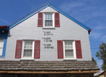
The general store displayed a record of historic floods, where normally placid currents overran the riverbank to submerge surrounding countryside. This solid cinder block structure withstood many torrents and torments in its lifetime and could probably survive a few more. Judging by the dates it seemed like another one was due. Then they’ll mop out the mess as they’ve done many times before and begin anew. The flood markers commemorated three events:
- June 24, 1972. Hurricane Agnes formed in the Gulf of Mexico, hit the Florida panhandle and crossed Georgia on its way to the Atlantic Ocean. From there it proceeded up the eastern seaboard to New York. Meanwhile it dumped nearly a foot of rain across much of the mid-Atlantic to become the country’s costliest hurricane of the time. Floodwaters reached nearly to the third floor window of the general store.
- January 21, 1996. The Potomac watershed received unusually heavy snowfall in the days leading to what would later become known as the Winter Flood of 1996. Warm temperatures and heavy rains combined with a rapidly melting snowpack, overrunning creeks and streams, and forcing the river from its shores. Floodwaters reached the top of the second floor windows of the general store.
- November 7, 1985. The remnants of Hurricane Juan stalled over the Appalachian Mountains. Once again water rushed down the watershed gullies, branches and tributaries feeding the Potomac River. Floodwaters reached about half way up the second floor windows of the general store.
The ferry is located north of Leesburg Virginia using Route 15, then east on Whites Ferry Road for about a mile. In Maryland it’s about 6 miles west of Poolesville using Route 107, likewise called Whites Ferry Road.
Readers who have an interest in ferries might also want to check my Ferry Index page.
Leave a Reply