
There are 29 Counties in Utah – “The Beehive State“
Also be sure to see my United States County Counting Page for the rest of the states.
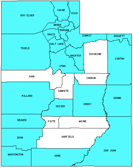
I have visited 22 Counties = 75.9% of Counties in Utah
Counties visited are colored-in; counties still needing to be visited are blank. Map created using Mob Rule.
Twelve Mile Circle Articles Featuring Places in Utah
Markers designate the Utah locations featured in Twelve Mile Circle articles.
Interesting Utah County Trivia
My candidate for the county with the most boundaries is Utah’s San Juan County. Fourteen neighboring counties share a border with it, including several at just a single point. This also marks Utah’s contribution to the 4-corners phenomenon. San Juan County’s fourteen neighbors are:
- Kane County, UT (West)
- Garfield County, UT (West)
- Wayne County, UT (West)
- Emery County, UT (Northwest at a single point)
- Grand County, UT (North)
- Mesa County, CO (Northeast at a single point)
- Montrose County, CO (East)
- San Miguel County, CO (East)
- Dolores County, CO (East)
- Montezuma County, CO (East) – one of the 4-Corner Counties
- San Juan County, NM (Southeast at a single point) – one of the 4-Corner Counties
- Apache County, AZ (South) – One of the 4-Corner Counties
- Navajo County, AZ (South)
- Coconino County, AZ (Southwest)
Counties in Utah

Below are the 29 counties in Utah. Although infrequent, counties sometimes do change so please let me know if any of this information is out of date and I will update it. Those counties that I have visited are highlighted in Red. Readers can also link to any articles manually in this section if the map isn’t working.
- Beaver
- Box Elder: ATK Rocket Park; Golden Spike National Historic Site
- Cache
- Carbon
- Daggett: Smallest county population in Utah (921 people in 2000 Census); COUTWY Tripoint
- Davis: Smallest county in Utah (305 square miles); Antelope Island State Park; Interstate 84 Geo-Oddity
- Duchesne
- Emery: Counterintuitive Saints
- Garfield: More Land than People, Part 2; Hardly Tropic
- Grand: Negro Bill Canyon; Arches National Park
- Iron
- Juab
- Kane
- Millard: Fort Deseret; Utah Territorial Statehouse
- Morgan
- Piute
- Rich: Rendezvous Beach at Bear Lake
- Salt Lake: Largest county population in Utah (978,701 people in 2000 Census); Alien Encounters; Desert Edge Brewery; Epic Brewing Company; Great Salt Lake Meridian & Base; Red Rock Brewing Company, Squatters Pub Brewery.
- San Juan: Largest county in Utah (7,821 square miles); Four Corners Reflections; Utah-Colorado Border Anomaly; Most County Borders in the United States; Adjacent Counties, Same Name, Different States; Natural Bridges; Four Corners – USA; Footloose
- Sanpete
- Sevier
- Summit: Wasatch Brew Pub & Brewery; Polygamy Porter
- Tooele: Bonneville Salt Flats; (West) Wendover: What Time? What State?; No more rest; NOT as the Crow Flies; Counterintuitive Saints
- Uintah
- Utah: Timpanogos Cave National Monument; Icelandic Diaspora
- Wasatch: Most Frequent Communities
- Washington: St. George Marathon; Inland Hurricane; Giant Arrow; St. George Utah Temple; Erastus Snow Monument
- Wayne: Loa
- Weber: Interstate 84 Geo-Oddity; Roosters Brewing Company.
Quick Facts About Utah
- Location: Mountain West United States. See map above.
- Size(1): 82,170 square miles. Utah is the 12th largest state. The next larger state is Idaho and the next smaller state is Kansas.
- Population(2): 3,161,105 people. Utah is the 30th most populous state. The next more populous state is Connecticut and the next less populous state is Iowa.
- Population Density: 38.5 people per square mile. Utah is the 40th most densely populated state. The next more densely populated state is Maine and the next less densely populated state is Kansas.
- Bordering States: Utah shares a border with 6 states: Idaho; Nevada; Arizona; New Mexico; Colorado and Wyoming.
- Admission to the Union: January 4, 1896. Utah was the 45th state admitted to the Union, after Wyoming and before Oklahoma.
- Capital: Salt Lake City.
- Highest Point: 13,528 feet at Kings Peak. See SummitPost’s Kings Peak page.
- Lowest Point: 2,000 feet at Beaverdam Wash in Washington County.
- Government website: Utah.gov – The Official Website of the State of Utah .
- Official Tourism website: Welcome to Utah.
- Still not enough? See Wikipedia’s Utah page.
Sources:
(1) Wikipedia: List of U.S. states and territories by area. Land area only.
(2) Wikipedia: List of states and territories of the United States by population. Estimated population on July 1, 2019.
Leave a Reply