
County counting becomes increasingly difficult as I continue my glacially slow progress. Now it takes more than five hours to reach the closest unvisited county from my home. Fortunately I found a workaround by shifting my focus to overnight county visits. There are plenty of counties nearby where I haven’t spent even a single night. How about I try some of those options between my extensive road trips?
And that’s how I decided to explore St. Mary’s County in the state of Maryland, just an hour away.

St. Mary’s occupies the state’s southernmost peninsula along the western shore of Chesapeake Bay (map). I’d only ever crossed its borders a single time despite the proximity. You don’t hit it randomly, you have to make an effort, and you have to be deliberate. It’s not on the way to anything else.
A coworker once held a barbecue at their residence and I spent an afternoon there maybe thirty years ago. That’s it. My only visit to St. Mary’s County.
Certainly it counted as a county visit and obviously better than my numerous “barely across the border for thirty seconds” county visits. Even so, definitely, I could improve upon my earlier result by wandering around and staying the night. Unfortunately my plan didn’t leave a lot of time — just Saturday afternoon into Sunday morning — so it became a whirlwind tour.
I consulted my Complete Index in search of suggestions and the vast number of options surprised me. I’d forgotten how many geo-oddities fell within this area. Some of them I experienced during my little trip and other I didn’t. Regardless I’ll reference several of those old discoveries by linking to earlier articles within bracketed text. For example, I drove straight through Hollywood [“California Tangential“] and California [“Outside of California“] in quick succession.
About That Apostrophe

Is it St. Mary’s (with an apostrophe) or St. Marys (without an apostrophe)? Well, it depends.
- The county of St. Mary’s includes the apostrophe. [“Particularly Possessive“].
- But the St. Marys River does not [“St. Marys River“].
- The Historic St. Mary’s City includes the apostrophe (see above).
- But the contemporary, adjacent St. Marys City does not (map)
I don’t make the rules, I just report what I see. Nonetheless I got to experience all four of these distinct geographic features named for the blessed virgin Mary during my adventure.
Piney Point Lighthouse

Water surrounds St. Mary’s county on three sides so I sensed an immediate opportunity to pad my lighthouse list. However, none of the terrain touched open ocean so lighthouses required less of a focal plane than usual.
For instance, the Piney Point Lighthouse sat on the banks of the Potomac River. Sure, the river was much wider here than further upstream in Washington, DC but even so it wasn’t much more than three or four miles wide. I could clearly see Virginia on the other side. Likewise, they didn’t really need an impressively tall lighthouse here. Instead they built a squat structure barely higher than the treeline and it was fine. Nonetheless, I didn’t feel any burning desire to climb to the top of it either because that would be silly on such a low riser.
Historic St. Mary’s City

Then we drove towards History St. Mary’s City, a living history museum located where Maryland’s original colonists first landed and established their capital. This required a jog onto Three Notch Road [“Three Notches“] and past Walk This Way [“He Went Thata Way“]. I probably would have stopped at Walk This Way back in the classic days of Twelve Mile Circle. Now it’s easy to get a good image on Google Street View so what’s the point? But I did point it out to my wife and we both laughed.
The settlement is kind of like a smaller version of Williamsburg, which I guess makes sense because Maryland’s colonial history doesn’t get the same attention as neighboring Virginia. I rather enjoyed strolling through it though, even if the park was beginning to wind down as winter approached. The grounds included a bunch of recreated historic buildings to explore as well as a modern replica of the Dove moored at a pier. The original ship was the smaller of two sailing vessels that brought settlers and supplies across the Atlantic Ocean.
Calvert Marine Museum

From there we crossed the Patuxent River and entered nearby Calvert County on the surprisingly impressive Governor Thomas Johnson Bridge. This thing really towered above the flat terrain, and reached a lot higher than any of the puny local lighthouses. We rose about 140 feet (43 metres) as we crossed between counties.
I’ve been to Calvert County one other time before — even staying overnight — so it didn’t “count” for my purposes this time. However, my previous visit involved the complete opposite end of the county. The latest crossing marked my first foray into the southern end at Solomons Island [“Mistaken Identity, Part 1“] much to my amusement.
I hadn’t planned to spend much time at the Calvert Marine Museum but it was convenient and I was there. Besides we had a little time to kill before dinner. So I got to learn more about local history, the rise and fall of the oyster industry, the dinosaur fossils collected from Calvert Cliffs, and all sorts of other Chesapeake Bay trivia. Actually it was all pretty impressive for a small town museum.
Drum Point Lighthouse
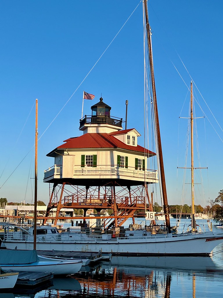
Of course I really visited the museum because it provided the only direct access to Drum Point Lighthouse. It’s an unusual screw-pile style structure dating to 1883. As the name implies, the lighthouse rested atop piles that were screwed into the seafloor. This one originally stood at the mouth of the Patuxent River for sixty years. Then technology replaced it and the county gained ownership from the Federal government and they moved it to the museum grounds.
Ruddy Duck Brewery

We remained in Calvert County for dinner, adding Ruddy Duck Brewery to my ever-growing list of brewery visits. Uncharacteristically I visited only this one single brewery during our weekend. There were a couple of nearby farm breweries but they were open only sporadically. I mean, who doesn’t offer a tasting room on a Saturday afternoon? Anyway, Ruddy Duck was open and it was a true brewpub that operated as an actual restaurant with a fully staffed kitchen.
Save it for Next Time
There were other places I would have visited if we’d been there for an entire weekend instead of a single night. For instance, the Patuxent River Naval Air Museum (just outside the gates of the naval air station of the same name) got good reviews. There was also another lighthouse at St. Mary’s southern tip. Finally, I probably would have taken my bicycle out on the flat, scenic routes along the coastline. Maybe someone else can do that. I added my new overnight and now I need to hit some different counties.
Leave a Reply