
Northern Wyoming (June 1992)
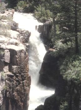
Shell Falls
We cut across northern Wyoming on Route 14 as we gradually began our Bighorn Mountains ascent. These mountains formed about 60 million years ago as the land forced upward. Erosion slowly scraped away the sedimentary rock in many places, leaving behind the harder granite beneath it. We entered the Shell Canyon, carved slowly through solid stone by a creek with the same name, and visited an interpretive center managed by the U. S. Forest Service.
A convenient parking lot provided a pull-off and an easily negotiated trail led down to a rustic bridge overlooking nearby Shell Falls (map). Here we learned that the falls got their name from numerous shellfish fossils found at the base of the falls. They became entombed in sandstone some 550 million years ago when this area sat at the bottom of a sea, but have gradually reappeared. They too owe their discovery to erosion. Many of the scenic wonder associated with this location are due to the magical force of water over time. At this spot, 3,600 gallons of water dumped forcefully every second over terraced granite shelves as the canyon suddenly dropped more than a hundred feet.
Readers who have an interest in waterfalls might also want to check my Waterfalls Index page.
Devils Tower
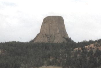
Later we cut to Interstate 90 and pointed our camper towards the far northeastern corner of Wyoming (map). We took a brief detour to Devils Tower National Monument. The forbidding basalt monolith gradually came into view, a loan buoy on a calm sea. The outcropping rose more than a thousand feet above the surrounding plain.
As dramatically as the tower appears, it’s hard to believe that the United States government didn’t documented it until 1859 when Captain W. F. Raynold’s Yellowstone Expedition came through the area. Native American of course knew about it for centuries and the monolith figured prominently in their rituals and folklore, but it took awhile for European-descended explorers to reach the area and formally record it. About fifty years later Devils Tower became the United States’ first national monument by proclamation of President Theodore Roosevelt. Now a century since its designation it is a popular spot for climbers, and there are ascents that range from challenging to downright insane. We were quite content to walking around the base and gaze upward, though.
Geology
Nobody is quite certain how the monolith formed. An intrusion of igneous material and cooling definitely took place. Geologists agree on that point, but this could have occurred in different ways. One theory claims that that it may be the plug or a neck of a volcano. The surrounding lands were all composed of sedimentary rock formed at the bottom of a sea. Much of that eroded away over the ages, but the harder basaltic rock that formed Devils Tower remained behind. Even so, the tower is not immune to erosion and the forces of nature slowly carve away at it. Piles of fallen debris collect at the tower’s base to demonstrate that it was once much larger.
Oral Traditions
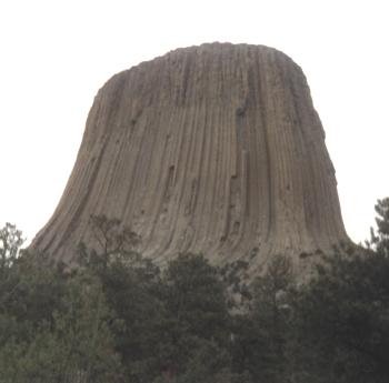
A closer view of Devils Tower shows the large, hexagonal basalt columns that are readily visible along its sides. There are various Native American traditions that involve a giant bear chasing children up the tower. The great bear couldn’t reach the summit but he clawed furiously at the stone as he tried to climb higher. Those markings remain on the tower. This rich oral tradition also provides an alternate name for the monolith: Bears Lodge. The National Park Service estimates that perhaps twenty Native American tribes have cultural ties to Devils Tower including the Lakota Sioux, Cheyenne and Kiowa tribes. Scientists have a less romantic explanation for these large columns. As hot lava cooled and dried it began to shrink and crack like mud does when water evaporates from it. Erosion then exposed columns over time.
Devils Tower also played a central role in the classic 1977 Steven Spielberg movie “Close Encounters of the Third Kind.” We stayed at a campground just outside the park, and of course they played this movie in its entirety on an outdoor screen each evening. I can’t possibly imagine that they still to that. It got old even then.
Leave a Reply