
Prince William Forest Park, Prince William Co., Virginia (April 2011)
We had an enjoyable overnight stay in Prince William Forest Park, tent camping with the Cub Scouts at the Turkey Run Ridge Group Campground. They were working on their Hiking Belt Loop and the den decided upon the Quantico Cascades Trail as their main afternoon activity. It’s a fairly leisurely trail without much difficulty, and that was the primary reason for selecting it over the various other choices in the park. It’s a nice short trail, not too strenuous for young kids, with beautiful scenery and the promise of cascades at the end to keep them motivated.
We hiked up the gently rolling Mary Bird Branch Trail for the first half-mile or so to the Quantico Cascades trailhead. Another option would have been to use Parking Area E on the Scenic Road but that was hardly necessary given our starting location. We proceeded through the thick woods for another half-mile before the path dropped quickly into a small gorge. The rushing waters of the cascades could be heard in the distance as we descended to the valley floor.
We hiked with wonderful expectations based on the interpretive sign at the trailhead:
“Follow the yellow blazes as this 0.7-mile trail joins Lake One Road for a short distance. The trail then heads off to the right and winds through pines and oaks along a ridge before descending to a series of cascades tumbling over rocks in Quantico Creek. Return the same way or circle back to the trail via North Valley Trail.”
Terrain
A sign along the trail explained that we were transitioning from the Piedmont region, literally the last remaining foothills of the Appalachian Mountains, to the lower, flatter coastal plain. This is a common phenomenon in these parts. This geographic reality created a reason for locating nearby cities such as Richmond and Washington; it’s the point where commercial ships could navigate no further thanks to the treacherous stone ledges and turbulent whitewater. Here the rivers and creeks drop from the weathered remains of an ancient mountain range to a lesser-elevated and flatter Atlantic Coastal Plain leading to the sea. The Quantico Cascades trailhead starts at about 300 feet above sea level. A few miles later when Quantico Creek joins the Potomac River, the elevation is literally just a few inches above sea level.
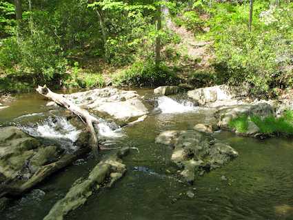
With great fanfare we finally reached Quantico Creek, hiked upriver briefly with the sound of rushing water growing louder and… well, the rather diminutive cascades came into view (map). I looked around to see if I could find the “real” cascades. Nope, these were them. Cascades is probably too kind a word to describe these puny ledges, but that’s what they’ve been dubbed. I would have been disappointed had the cascades been the sole reason for the hike. Fortunately that hadn’t been the purpose at all. It was a lovely day, a beautiful hike, and a chance to spend some quality time with the kids. I’d still recommend the trail as a leisurely get-away despite its misleading name.
Readers who have an interest in waterfalls might also want to check my Waterfalls Index page.
Leave a Reply