
Various Points in Scotland (January 2000)
We used to be able to take spur of the moment trips before we had children. Thus, all the way back in 2000, one of the airlines offered an absurdly low fare for a last-minute trip to Glasgow, Scotland. I think it was something really crazy like $120. But it was like the middle of the week with three days notice. We had to do it. We bought tickets, packed our bags and headed to an unlikely destination for a January holiday. It could have been a complete disaster with the weather but we didn’t care. Fortunately, we got really lucky and it stayed clear and unusually warm for that time of year.
We covered a decent amount of ground in just a few days. The map above shows the approximate route of our journey. Also, I apologize in advance for the bad photography. I didn’t own a digital camera back then.
Glencoe
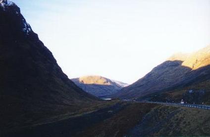
We based ourselves near the town of Glencoe (map) in the strikingly beautiful Scottish Highlands, in a valley with the same name, Glen (“valley”) Coe. We decided in advance to stay in rural Scotland away from the cities, and chose Glencoe deliberately. It worked out perfectly. We had little difficulty driving to nearby regions and returning to Glencoe for the night.
Twisting, meandering roads required careful attention. However, they provided amazing views like the one shown above. I took this photograph from one of the many roadside pull-offs. On the weekend, they served as the starting points for mountaineers hoping to scale the steep peaks rising above the glen. Although we enjoy hiking, the heights and the brutal weather were well beyond our abilities. So we certainly didn’t mind confining ourselves to the valley sampling Real Ales.
Historical Footnote: An important event in Scottish history took place here in 1692: The Glen Coe Massacre.
Stirling
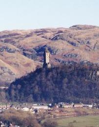
The impressive Wallace Monument stood above the valley north of Stirling (map). The Scots built it to commemorate William Wallace, an opponent of English domination in the late thirteenth century and a symbol of Scottish self-determination. I took this photograph as we approached the entrance to Stirling Castle, not far from the Robert the Bruce statue.
Stirling Castle became important in the fifteenth century, grew from there, and has been maintained ever since (map). We particularly enjoyed visiting the Regimental Museum of the Argyll and Sutherland Highlanders. Much of the castle had been restored to its original condition and additional restorations were in progress.
Loch Ness
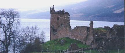
The remains of Urquhart Castle rested atop the western bank of Loch Ness, near Drumnadrochit (map). The castle commanded the Great Glen between the thirteenth and seventeenth centuries. Then it became strategically unimportant and fell into decay. While this makes it rather picturesque, one can imagine how imposing it must have seemed in its day.
At the center of the photograph is the tower-house. At one time it included a bedchamber and a dining room for the lord, a defensive platform, a garret, and a basement storage cellar. The foreground contained a causeway to the gatehouse entrance. Most of the castle sat off to the right, outside the range of the photograph. Loch Ness shimmered in the background, but we detected no signs of the monster.
We completed a circle around Loch Ness, including a brief stop in Inverness for lunch and a little shopping. On the eastern side we viewed a waterfall tucked in a hollow below the town of Foyers. Some of the eastern road section went down to a single lane with pull-offs for oncoming cars. I successfully navigated through obstacles mainly because there weren’t any other vehicles. Fortunately within a couple of days I overcame my long-standing fear of driving on the left and finally it became intuitive.
Skipness
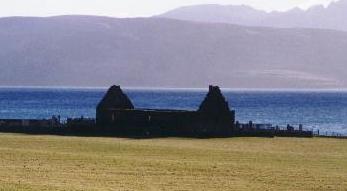
We found ourselves on the Kintyre peninsula along the western coast of Scotland, in a town so small it didn’t appear in most of our guidebooks. Skipness contained only a few houses and a general store (map). However, its location on the Kilbrannan Sound and its views across the sound to the Isle of Arran provided a remarkable blend of sky, sea, and land.
We parked where the road stopped and walked a short distance to the Skipness Castle ruins. A few hundred yards away toward the Sound stood the remains of St. Brendan’s Chapel. The nearby Isle of Arran stood in the background across the water. On a sunny, calm, well-above-freezing January day, not a single other person stood there with us.
Largs
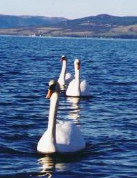
Then we found Largs mostly by accident, about thirty miles west of Glasgow on the Firth of Clyde (map). We decided to stay out of the Highlands on our final night to make sure we could reach the airport the next morning. We wanted a location near the airport but also somewhere scenic, and Largs matched both needs. Then we got lucky and had another beautiful, sunny, well-above-freezing day. The townspeople appreciated the weather too. Many of them strolled along the promenade that hugged the coast. Opportunistic swans begged for handouts.
We had perfect weather in Largs the next morning and began the drive back to Glasgow. A huge dome of fog hugged the airport in an obvious case of foreshadowing. Our flight barely made it out. The connecting flight went well but then the largest snowstorm of the season smacked much of the eastern United States, closing dozens of airports, canceling more than two thousand flights, and stranding us several hundred miles from home in Boston. Fortunately the airline placed us in a hotel for the night and our flight continued the next morning. When we got back we had to dig our car out of the airport lot, and dig up our driveway back home. Total elapsed travel time: 35 hours. I’m not complaining, we had a great time, but this is why tourists are scarce and hotels are cheap during the off-season.
Leave a Reply