
I didn’t have a proper vacation in awhile. Then, unexpectedly, I had abundant time on my hands. I also needed to bring a kid home from Michigan State University who just finished the first year of a graduate program. So I planned a delightfully inefficient route through rural eastern Ohio to build my County Counting list. I haven’t added much to that lately and this was a nice opportunity.
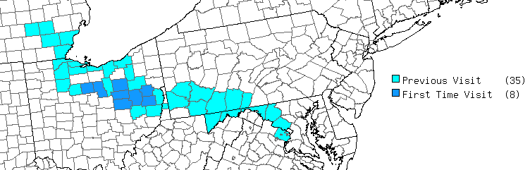
My map from mob-rule.com shows the result. Eight new counties; six on the way up and two on the way back. My route didn’t have much of a common theme but I finally figured one out: the area west of the Eastern Continental Divide used to be the frontier during the latter half of the 18th Century through the first half of the 19th. In a sense I would be exploring a smattering of history from the “frontier.”
On the Way

The drive out from the Washington, DC area wasn’t encouraging. It rained hard the previous day and a cold drizzle lingered like a hangover. Heavy traffic combined with tractor-trailer spray added to the misery. Then I climbed Sideling Hill in Western Maryland and entered a dense fog (map). Usually I look forward to this wonderful view, or at least admire at the massive road cut, but not this day. I couldn’t see anything.
French and Indian War
Conditions improved somewhat as I pushed further west into Pennsylvania, although it remained cloudy and blustery. Here I followed the path of the old Braddock Road, now U.S. Route 40. This was an important link during the French and Indian War (Seven Years War) fought principally between Great Britain and France in the 1750’s.
Fort Necessity

The roots of the conflict stemmed from overlapping territorial claims to the North American interior, and a young George Washington unwittingly ignited the spark. He led a company of Virginia colonial troops and Native American allies that ambushed a small force of French Canadians soldiers at nearby Jumonville Glen in 1754. Obviously the French were none too pleased about that and they vowed to drive the British out.
So Washington constructed a defensive position, a basic stockade dubbed Fort Necessity along with some hastily dug trenches for protection (map). It wasn’t much and it left his troops exposed in muddy ditches in a pouring rain. A much larger French force fired from the relative safety of a nearby forest with lots of places to hide.
This was the only time Washington ever surrendered. Fortunately for him, the French allowed Washington and his troops to leave honorably. They marched away quietly with their tales tucked between their legs. Three decades later, and soon after Washington secured the independence of the United States, he actually purchased this same tract of land.
Braddock’s Tomb

But this whole episode didn’t go away quietly. It enraged British leadership after news crossed the Atlantic, and they amassed a sizable military force hoping to expel the French for good in 1755. Ultimately the entire expedition collapsed in pretty spectacular fashion.
General Edward Braddock led the assembled troops, building a military supply road (i.e., Braddock Road) as he pushed further into the disputed frontier. They made it nearly to the French garrison at Fort Duquesne (modern-day Pittsburgh) before a decisive defeat and retreat. Braddock, badly wounded, died near the spot where Washington lost at Fort Necessity just a year earlier. So his troops buried him under the wilderness road in an unmarked grave to avoid any desecration of his body. And then they continued their retreat. Road workers found Braddock’s remains a half-century later and he finally got a proper burial (map).
Shoot & Eat!

Well that was fun but I continued onward, into the skinny neck of West Virginia’s northern panhandle. I stopped for a break and noticed an interesting shopping combination: Shoot & Eat! I’d totally do that, if I were shooting and I were hungry. But I was neither that day. I’ll bet it’s a lot safer than some of those pubs with ax throwing.
The address is 45 Caliber Drive (map), which seemed completely appropriate.
Ohio & Erie Canal
The historical exploration continued, into an era when the new United States began to expand and prosper. Railroads didn’t exist yet but goods still needed to move from the new frontier to the coastal markets. This was a period of extensive canal building, and the Ohio & Erie Canal was particularly distinctive example starting around 1830 and lasting up to the Civil War.
Historic Roscoe Village

Towns and villages sprung up along canals, serving as gateways and ports. One of those was Rosco, on the edge of current Coshocton, Ohio (map). Rosco actually predated the canal by a decade but it blossomed when the canal arrived. However, prosperity faded once railroads replaced canals. In the 1960’s, a local philanthropist restored what remained of the settlement to create a living history museum, Historic Roscoe Village. It’s like a miniature Williamsburg of a different era, with museums interspersed among quaint shops and restaurants.
This is why I enjoy my County Counting hobby. I never would have discovered Historic Roscoe if I hadn’t created an artificial reason to poke into these hidden corners.
Canal Boat Monticello

The weather improved dramatically by the time I crossed into Ohio. It was nice enough to walk a mile from Historic Roscoe to a restored portion of the canal that featured a reconstructed boat, the Monticello III. The first Monticello was an original canal boat. I have no idea what happened to the second one, but this was the third one.
Mules or horses walked along a towpath next to these boats, pulling forward with each step, as recreated by Monticello III. Unfortunately it was a little too early in the season for a ride but maybe I’ll return someday.
Behalt

Then I drove a little further north and crossed into Holmes County, where I stayed overnight. Holmes actually appeared in an earlier Twelve Mile Circle Article. It had the distinction of having the highest percentage of “undifferentiated Amish Groups” of any county in the United States. In fact, it is on track to become the first majority Amish county sometime this decade because the population is rising rapidly.
I stopped at the Behalt Amish and Mennonite Heritage Center (map). Behalt means “to keep, hold, remember” so the name seemed appropriate. They have guided tours on the hour and I missed one by a few minutes. Fortunately they were kind enough to give me an abbreviated, personal tour of the schoolhouse and barn where I learned a ton of fun facts.
Most notably, the Amish and the other Anabaptist groups (e.g. Mennonites and Hutterites) are not a monolith. There is a wide continuum of beliefs even among just the Amish portion, which also reflects the degree to which they embrace or eschew technology. For instance, I saw some Amish on bicycles, some on electric bicycles, and some even on electric golf carts! Ditto for buggies; some had windshields, reflectors, and LCD lights, and some did not.
The docent explained that each congregation voted on its own rules and there were something like 300 congregations in the area! This made it particularly challenging to drive around the back roads on a school day because each of the 300 had its own one-room schoolhouse, and I had to slow down every few feet it seemed. Holmes County also has a public Amish school system in addition to the parochial schools, which fascinated me even more for some reason.
I wish I could have stayed here longer.
Be sure to check out Part 2 where I see more sights and add to my lists.
Leave a Reply