
South of Stockholm, Wisconsin (June 2009)
We noticed an unusual roadside historical marker (map) on our journey down Wisconsin’s portion of the Great River Road just south of the small town of Stockholm. We pulled over to check it out. It read:
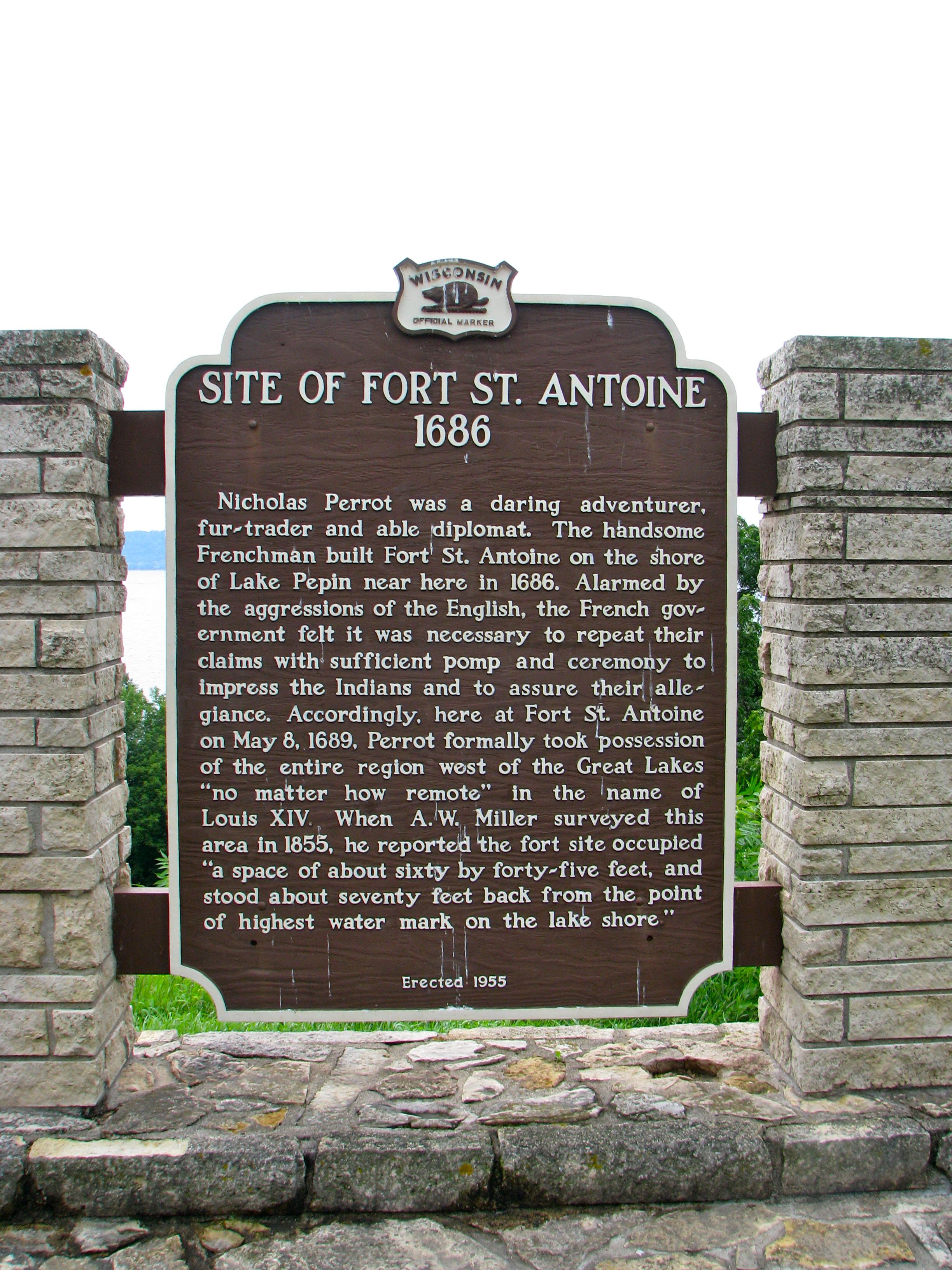
Wisconsin Official Marker. Site of Fort St. Antoine 1686. Nicholas Perrot was a daring adventurer, fur-trader and able diplomat. The handsome Frenchman built Fort St. Antoine on the shore of Lake Pepin near here in 1686. Alarmed by the aggressions of the English, the French government felt it was necessary to repeat their claims with sufficient pomp and ceremony to impress the Indians and to assure their allegiance. Accordingly, here at Fort St. Antoine on May 8, 1689, Perrot formally took possession of the entire region west of the Great Lakes “no matter how remote” in the name of Louis XIV. When A. W. Miller surveyed this area in 1855, he reported the fort site occupied “a space of about sixty by forty-five feet, and stood about seventy feet back from the point of highest water mark on the lake shore.” Erected 1955.
The Fort

I hadn’t realized that the French built forts this far into the Wisconsin interior this early in the European exploration of North America, and when I returned I attempted to find out more. The historical marker provided a good overview but there’s more to the story. Nicholas Perrot had been appointed the French “Commandant of the West” with his base at Green Bay. He set out with twenty of his men in search of trading opportunities with distant Native American tribes. He followed the Fix River with a portage to the Wisconsin River as a gateway to the Mississippi River.
Perrot wintered-over at a stockade he built on the Trempealeau Prairie about a mile north of the current town of Trempealeau. Perrot State Park now marks the general location where he and his soldiers sought refuge from the cold and the snow. That Spring, Perrot traveled another sixty miles further upriver and constructed Fort St. Antoine.
This was a crude structure and it wasn’t occupied continuously. It also wasn’t much of a “fort” either in the traditional sense. It was more akin to a fortified trading post. Perrot, along with other explorers and traders, would return to this spot occasionally when they came through the area. He laid claim to the watershed mentioned on the historical marker during one of these periodic visits. It was described as a territory including the St. Croix, St. Peter and Upper Mississippi valleys.
On the Border
The French used Fort St. Antoine as a means to trade with Eastern Dakota Sioux. This troubled the Wisconsin tribes who felt betrayed by the French. The tribes of Wisconsin had long been rivals of the Sioux bands located further west. The Fox Indian Wars began to heat up right around this same time, making it nearly impossible for the French to reach their trading post on the edge of Sioux territory.
Fort St. Antoine may have been nicely located to exploit an abundance of furs and trading relationships, but this also placed it on the borderlands between rival tribes. It experienced frequent harassment and threats to the point where the situation became untenable. The French probably abandoned Fort St. Antoine around 1690, and gave up efforts within a large swath of the Upper Mississippi for the next quarter century. Trade in the Upper Mississippi was virtually abandoned during that period. Fort St. Antoine crumbled into the surrounding terrain.
Readers who have an interest in forts might also want to check my Forts, Fortresses and Fortifications page.
Leave a Reply