
Sullivan’s Island, South Carolina (September 2008)
Sullivan’s Island brackets the northern entrance to Charleston Harbor. It seemed natural that a defensive fort should rise along the southwestern flank of the island to protect a vital port city further upstream. From this strategic spot, any ship entering the main shipping channel would pass less than a mile from Fort Moultrie’s punishing batteries (map). Cannons could easily reach across the harbor entrance to target any foe approaching the harbor. Colonists recognized this early in American history and a fort rose quickly in those initial months of independence. The fort allowed American troops to thwart an initial British attempt to capture Charleston in 1776.
The Early Years
The colonists built that initial fort hastily of palmetto logs and sand. This protected defenders well during a nine hour bombardment. Shots simply bounced off of the logs or burrowed into the sand. Colonists returned fire on an exposed British fleet sitting unprotected in open water. In this manner, a colonial force with just 30 guns repulsed a superior British fleet with 200. William Moultrie commanded those initial defenders, and the fort took his name in his honor from that time foreword. Charleston would remain free for another four years until British troops finally bypassed Fort Moultrie entirely and attacked overland from the south.
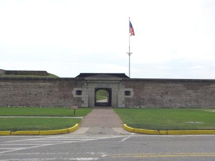
The photograph above shows the sally port that forms the entrance to the fort. This appears on the back side of the fort along Middle Street, across from the Visitors Center. The Fort Moultrie historic site forms part of the larger Fort Sumter National Monument, maintained in perpetuity by the National Park Service (See my Fort Sumter page). The original palmetto log structure no longer exists but it would have been closer to the harbor, at the spot shown in the opening sequence of the video at the top of this page.
A Long History
Fort Moultrie formed a part of America’s seacoast defensive system in the years immediately after independence. The second Fort Moultrie on Sullivan’s Island blew away in a hurricane in 1804, but the third one rose in 1809. That one now forms the outline of the current structure.
The United States protected its important cities along its coastal waterways fiercely, including Charleston. Fort Moultrie could be used in concert with other nearby installations such as Fort Sumter and Castle Pinckney, both in the middle of Charleston Harbor, along with Battery Wagner on the opposing side of the harbor entrance at Morris Island. This formed a deadly crossfire. Any approaching enemy would think twice before trying to force its way into the harbor.
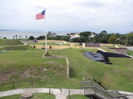
Today, the grounds of Fort Moultrie have been restored to provide the full history of the fort, not just a single era. I took the photograph above from a command and communication post constructed during the Second World War. It looks down upon iron bunkers from the turn of the last century (center right), Civil War era artillery placements (back perimeter wall) and early 19th Century barracks foundations and gunpowder magazine (center, in yellow brick). This compact site can be walked easily, but narrow staircases and tunnels remain in some spots. These serve as a reminder of the original purpose, a military fortification rather than a tourist attraction.
Civil War
Fort Moultrie may be remembered most from its service during the Civil War. Federal troops abandoned the fort when South Carolina seceded from the Union. They retreated to a defensive position in the middle of Charleston Harbor, to a man-made island topped by Fort Sumter. They did this for an obvious reason. Fort Moultrie had been designed to pummel ships entering the harbor, not to defend against land-based attacks. Federal troops found themselves completely encircled within hostile territory in a fort facing the wrong direction. Secessionist forces quickly claimed the abandoned fort.
Shots on Fort Sumter
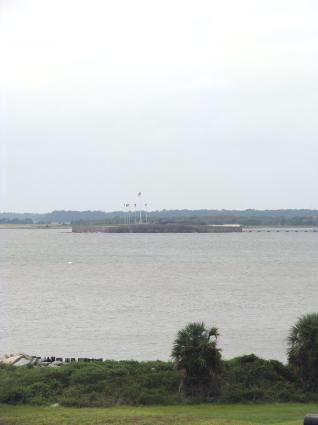
Three and a half months later, April 12, 1861, the guns of Fort Moultrie and other nearby batteries trained on Fort Sumter to ignite the Civil War. The photo shows a view from the walls of Fort Moultrie facing towards Fort Sumter in the middle of the harbor, flags clearly visible. This didn’t cover much distance and provided a clear, unobstructed line-of-sight that allowed pulverizing shots to be lobbed across the channel. Fort Moultrie continued to serve in battle throughout the war but its historical high-water mark may have been its involvement on that very first day.
It might be appropriate that some of the first shots of the Civil War came from Fort Moultrie for sheer poetic justice. For Sullivan’s Island provided the initial destination for literally millions of African people completing their brutal trip across the Middle Passage, to be isolated in quarantine before shipment to slave markets throughout the colonies. According to Wikipedia, this became the largest slave port in North America and about half of all African Americans in the United States can trace an ancestor through here. How fitting that the beginning-of-the-end of this terrible institution had roots in a spot that had for so long perpetrated it.
Later Years
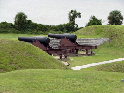
Rifled cannons made masonry forts like Moultrie obsolete by the time of the Civil War. Federal troops reduced it nearly to rubble by the end of the conflict. Nonetheless, Fort Moultrie continued to serve as a coastal defense in the post-war era with more sophisticated disappearing breach-load cannons and iron batteries.
The purpose of the fort shifted. It transformed into an outpost that could tend a minefield across the harbor should that ever become necessary. In later years it housed antiaircraft guns to defend against attack from the air, and finally it served as a communications outpost to coordinate defenses among a much larger geographic area. Modern warfare outstripped the usefulness of coastal defenses such as Fort Moultrie. It simply would not offer much usefulness in the modern methods of war. We are fortunate that it has been converted into a national monument, preserved for historical purposes and open to the public by the National Park Service.
Readers who have an interest in forts might also want to check my Forts, Fortresses and Fortifications page.
Leave a Reply