
Marigot, Saint-Martin (March 2011)
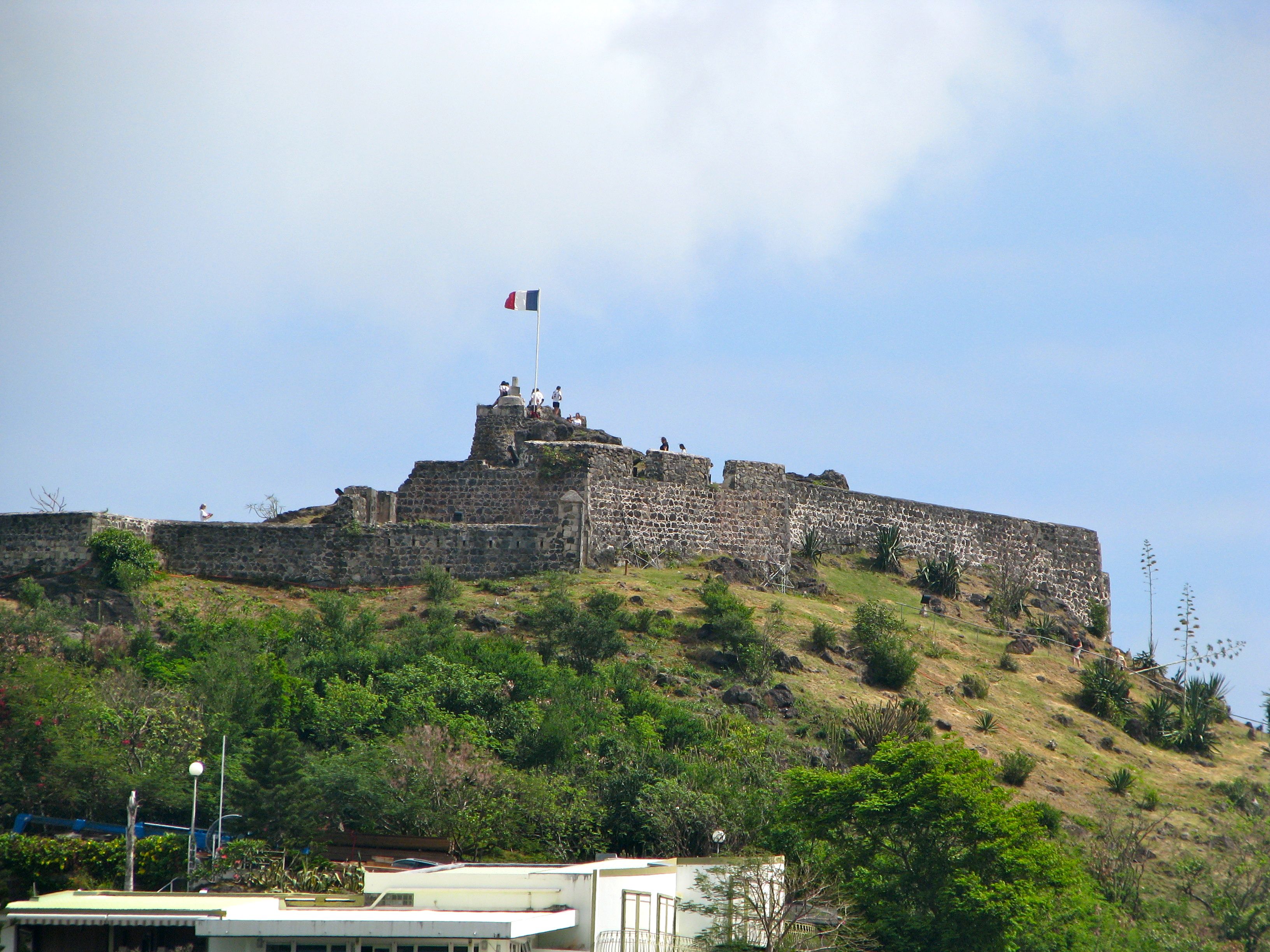
We saw a large hill along the shoreline as we drove down St. Martin’s western coastal road from Grand Case heading into Marigot. An old fortification graced the summit, the ruins of old Fort-Louis (map). We cut into Marigot proper and headed towards the marketplace on this Wednesday morning, arriving early in the day to take advantage of the outdoor stalls set up to sell local crafts and mementos. Wednesdays are a big day at the market along with Saturdays and we were ready to browse in a leisurely fashion (see my Marigot Market page).
The fort atop the hill remained within steady view to add an historic backdrop to the colorful displays of the vendors. It didn’t take long to get our fill of the market. Bus after bus disgorged hundreds of cruise ship passengers, soon packing the market to overwhelming densities. Certainly the market is timed to take best advantage of the cruise ship schedules and vice versa, and perhaps the market wouldn’t be nearly as successful without the tourist crowds. However it’s hard to enjoy the experience when packed tightly in a small area when the purpose is to browse. We needed to find a quieter space so we headed towards the fort.
Climbing the Bluff
We could see the fort from the market but we couldn’t figure out right away how to get to the top of the hill. One option would be to follow the street grid. While that’s the most efficient way to drive up to the fort where there is a small parking lot, there are more direct paths that can be taken on foot.
Facing the West Indies Mall from the Marigot market, there is a stone staircase built into the hill a little to the right of the mall. It could probably use a bit of maintenance, the steps don’t have much consistency, the path jogged slightly at points, and we had our doubts where it might actually lead, but indeed it climbed right up to the parking lot. From there it’s another round of steps leading directly to the fort.
It is not a particularly strenuously climb. Anyone in even moderate shape should be able to reach the summit from the base of Marigot without too much difficulty. However it didn’t appear to be handicapped accessible even if someone decided to drive up and use the parking lot. The lot was filled, by the way, and we were not visiting during the height of the tourist season. The much better option would seem to be the staircase located next to the West Indies Mall.
Colonial Powers
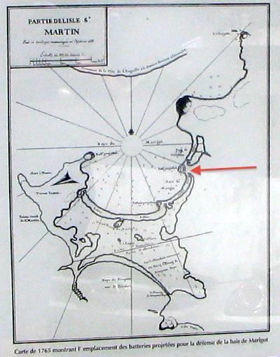
The ruins had plenty of signs explaining its historical context. One included this copy of a 1765 map showing Marigot, which I’ve marked with a red arrow, and the bay that required protection.
European colonial powers jockeyed for territory in the Caribbean throughout the Seventeenth and Eighteenth Centuries. The island of Saint Martin was not immune. It changed hands a number of times until the Treaty of Concordia split the isle between France and the Netherlands in 1648, an arrangement that continues to exist to this day.
The French
A French village rose along the bay towards the end of the Seventeenth Century. It became known as Marigot, based on an old French word referring to marshes, in deference to the mangrove swamps and wetlands that ringed the town along the seashore. Islanders produced tobacco, cotton, indigo, sugar cane, coffee, salt, rum and staples such as that, storing them in warehouses along the wharves in Marigot for shipment to more distant places. The town grew in importance and eventually became the French capital in St. Martin.
The British
The Dutch who shared the island with them weren’t the problem. It was the British. They controlled the nearby island of Anguilla, so close to St. Martin that it can be seen easily with the naked eye directly across a narrow channel just a few miles away. Today a ferry can cross that distance in twenty minutes, and it wasn’t much longer than that under sail. British privateers and pirates repeatedly harassed French settlers, stealing what they could, burning what they couldn’t, and scattering the populace in their wake.
A Fort Offered Protection

Chevalier (“Knight”) Descoudrelles who commanded of the islands of Saint-Martin and Saint-Barthélemy judged the defenses of Marigot to be inadequate, installing batteries on Point Bluff, Round Hill and Marigot Hill.
He understood the strategic value of the town, stating “Marigot is a beautiful and vast bay located on the North-western part of Saint-Martin, it is convenient and sheltered, the larger vessels being able to drop anchor in the offing from 15 to 30 fathoms and the small ones from 2 1/2 to 1 1/2, very close to land, good bottom of white sand without rocks or reefs…” in a 1775 report, according to one of the interpretive signs posted at Fort Louis. He brought a level of security and prosperity that allowed the settlement to grow.
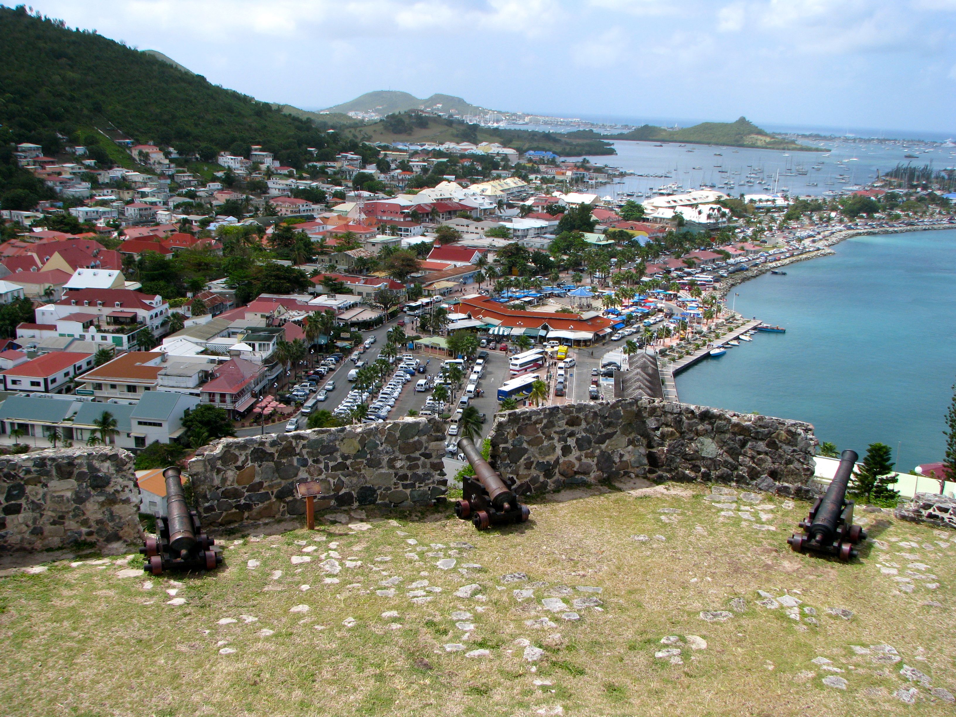
Fort Louis came soon thereafter in 1789 under Chevalier Durat, as an imposing and visible sign of defense. Fortification plans came across the ocean from France and the citadel took the name of the king, Louis XVI, just prior to the French Revolution. Cannons hugged the perimeter. No ship could land in Marigot from any direction without coming into the range of direct defensive firepower from high above. The fort isn’t particularly large but it didn’t have to be. It simply had to serve as a perch to pound foes with withering firepower who couldn’t touch it in return. Anyone attempting to enter the bay with hostile intent would be decimated.
Obsolescence
The fort began to lose its purpose with friendlier relations between European nations and changes in the technology of warfare. Its abandoned and crumbling ruins remained atop the steep hillside. It became an overgrown and deteriorating wreck by the time people started appreciating its historical significance and began restoration efforts in the late 20th Century. The ruins have now been stabilized and opened to visitors.
Visitors should visit the fort for its amazing 180° view even if they don’t have an interest in its history. We could see clearly all the way to Simpson Bay and the airport control tower. It also afforded a great birds-eye view of Marigot and the colorful market where we’d shopped in earlier in the day.
Readers who have an interest in forts might also want to check my Forts, Fortresses and Fortifications page.
Leave a Reply